Santa Luzia, Cape Verde
 Terrain map of Santa Luzia | |
 | |
| Geography | |
|---|---|
| Location | Atlantic Ocean |
| Coordinates | 16°45′41″N 24°44′38″W / 16.76139°N 24.74389°W |
| Archipelago | Cape Verde |
| Area | 35 km2 (14 sq mi) |
| Length | 12.3 km (7.64 mi) |
| Width | 5.3 km (3.29 mi) |
| Highest elevation | 395 m (1,296 ft) |
| Highest point | Monte Grande (also as Topona) |
| Administration | |
|
Cape Verde | |
| Concelhos (Municipalities) | São Vicente |

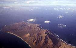
Santa Luzia is an island of the Barlavento archipelago in Cape Verde located between São Nicolau and São Vicente, the channel of Santa Luzia separates the island of São Vicente and is 8 km long. The area is 35 km² (some reads 34 km²). Like all Cape Verdean islands, it island is of volcanic origin. The highest point is Monte Grande or Topona elevating 395 m, the second elevating 344 m and the third elevating 337 m, other mountain tops include Agua Doce or Agua Dolce (315 m) and the fifth tallest is Monte Espia located to the south elevating 294 m. Hills named Crioulo (also as Creoulo) is in the east and elevates 85 m and Topino da Praia elevating 19 m. Santa Luzia is 12.3 km long and 5.3 km wide.
It is administratively a part of the municipality of São Vicente (sometimes called municipality of São Vicente and Santa Luzia), the abandoned settlement is a part of the village of Ribeira do Calhau located in the east of São Vicente. Until the late-19th century, it belonged to the municipality of São Nicolau along with its eastern islets.
Along with the islets of Branco and Raso, they are on the tentative list of UNESCO's World Heritage Sites, one of eight in Cape Verde that are nominated, no date is set.
History
The seamount was formed in around 122 million years ago from the older ocean crust during the Cretaceous Period.[1]
During the Ice Age, Santa Luzia along with São Vicente and Santo Antao were a part of the Northwestern Island which was the size of about 1,500 km2. Around 5,000 to 4,000 BC, the island split and the islands of Santa Luzia and the islets of Ilhéu Branco and Raso formed after sea levels rose in the Late Ice Age.
The island was discovered in around 1462 on Saint Lucy's day. The island was never colonized sustainably.[2] It was later home to a small agricultural population in the eighteenth century. The first settlers came from São Nicolau, one of the first settlements in a region including the island of São Vicente. Around 1831 and 1833, desertification led to its abandonment. It later acted as a hermitage. Shepherds used the island as a cattle pasture for horses and donkeys. It is home to a unique lizard. In the 20th century, a meteorology station was built. Today, fishermen from the nearby island of São Vicente fish within the island.
Santa Luzia and its two eastern islets Ilhéu Branco and Raso were declared a protected area as "Santa Luzia Nature Reserve" (Reserva Natural de Santa Luzia) in 2003. Endangered flora and some fauna are founded on the island.
Geographic features
Promontories:
- Ponta dos Piquinhas - northernmost point of the island
- Ponta de Salina - north
- Ponta do Crioulo - northeast, easternmost point of the island
- Ponta da Mãe Grande - east
- Ponta dos Tarafes - southeast
- Ponta da Laje de Areia - south
- Ponta de Praia - west
- Ponta Branca - westernmost point of the island
Streams:
- Northern stream
- Ribeira do Melãs - eastcentral
- Two eastern streams
- Stream east of Monte Espia
- Ribeira de Casa
- Four other streams emptying into Praia de Palmea Testão
- Ribeira do Curral
- Ribeira de Ponta Branca
- Ribeira de Agua Doce
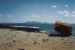
Beaches:
- Praia do Castelo
- Praia de Roque - the southernmost point of the island
- Praia de Prainha Branca - south
- Praia de Palmea Testão - southwest
World Heritage Site elevation plans
A plan to make the nature reserve together with the two eastern islets as a World Heritage Site began as a nomination, one of eight in the tentative list. No plans have been made.
Notes
- ↑ Muller, R., Sdrolias, M., & Roest, W.: Age, spreading rates and spreading symmetry of the world’s ocean crust. In: Geochemistry Geophysics Geosystems. 9(Q04006), 2008, S. 1525-2027.
- ↑ Armand d'Avezac and Eugène de Froberville, Îles de l'Afrique. L'univers : Histoire et description de tous les peuples, Firmin-Didot, Paris, 1848, p. 214
External links
| Wikimedia Commons has media related to Santa Luzia (Cape Verde). |
- Santa Luzia at Protected Areas of Cape Verde website (Portuguese)
Coordinates: 16°45′41″N 24°44′38″W / 16.76139°N 24.74389°W
| Island groups | ||
|---|---|---|
| Islands | ||
| Islets | ||