Scamander, Tasmania
| Scamander Tasmania | |||||||
|---|---|---|---|---|---|---|---|
 | |||||||
 Scamander | |||||||
| Coordinates | 41°27′S 148°16′E / 41.450°S 148.267°ECoordinates: 41°27′S 148°16′E / 41.450°S 148.267°E | ||||||
| Population | 506 (2006 census)[1] | ||||||
| Postcode(s) | 7215 | ||||||
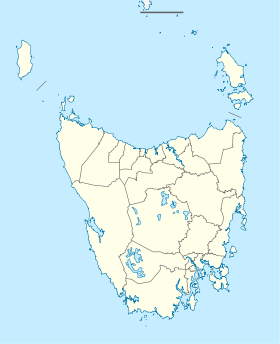
| Location |
| ||||||
| LGA(s) | Break O'Day Council | ||||||
| State electorate(s) | Lyons | ||||||
| Federal Division(s) | Lyons | ||||||
| |||||||
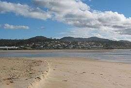
Scamander is a small town at the mouth of the Scamander River between St Helens and St Marys on the north-east coast of Tasmania in Australia. The town is a popular holiday destination because of its wide, sandy beaches and views of the ocean. Recreational activities include surfing, swimming and fishing for bream in the river.
History and Climate
The first European to travel through the area was surveyor John Helder Wedge in 1825. He named the river "Borthwick" and the position itself he named "Yarmouth" after the English port Great Yarmouth but both the river and town were both later renamed "Scamander".
The wide river mouth has been a challenge to bridge builders for many years. Richard Terry constructed a timber bridge in 1865, but it later collapsed when a large herd of cattle was driven across it. A second and third bridge were successively washed away in floods in 1889 and 1911. Further bridges succumbed to flood and shipworms, the last timber bridge collapsing in 1929. A truss bridge was built in 1936 and still stands today, used by pedestrians and bicycles. The concrete bridge that currently carries the Tasman Highway was built on a better alignment nearby and officially opened on 26 June 1991.
Scamander Post Office opened on 1 October 1896 and closed in 1933. It reopened in 1950.[2]
On the evening of 11 December 2006, 18 houses and a restaurant were razed by a bushfire that swept around the small town.[3] In 2009, the town recorded Tasmania's highest ever temperature of 42.2 °C (108.0 °F) on January 30.[4]
| Climate data for Scamander (1974-2013) | |||||||||||||
|---|---|---|---|---|---|---|---|---|---|---|---|---|---|
| Month | Jan | Feb | Mar | Apr | May | Jun | Jul | Aug | Sep | Oct | Nov | Dec | Year |
| Record high °C (°F) | 42.2 (108) |
39.8 (103.6) |
34.8 (94.6) |
29.3 (84.7) |
24.7 (76.5) |
20.1 (68.2) |
21.8 (71.2) |
24.9 (76.8) |
29.7 (85.5) |
31.7 (89.1) |
34.7 (94.5) |
35.6 (96.1) |
42.2 (108) |
| Average high °C (°F) | 22.1 (71.8) |
21.7 (71.1) |
20.7 (69.3) |
18.8 (65.8) |
16.6 (61.9) |
14.4 (57.9) |
13.8 (56.8) |
14.8 (58.6) |
16.3 (61.3) |
17.4 (63.3) |
19.0 (66.2) |
20.3 (68.5) |
18.0 (64.4) |
| Average low °C (°F) | 12.7 (54.9) |
13.0 (55.4) |
11.8 (53.2) |
9.8 (49.6) |
7.5 (45.5) |
5.5 (41.9) |
4.5 (40.1) |
5.3 (41.5) |
6.6 (43.9) |
8.1 (46.6) |
10.3 (50.5) |
11.3 (52.3) |
8.9 (48) |
| Record low °C (°F) | 5.1 (41.2) |
5.3 (41.5) |
2.6 (36.7) |
2.0 (35.6) |
0.0 (32) |
−2.2 (28) |
−3.0 (26.6) |
−1.2 (29.8) |
−0.2 (31.6) |
0.1 (32.2) |
1.8 (35.2) |
3.8 (38.8) |
−3.0 (26.6) |
| Average rainfall mm (inches) | 55.2 (2.173) |
45.2 (1.78) |
66.7 (2.626) |
69.0 (2.717) |
53.9 (2.122) |
54.0 (2.126) |
54.2 (2.134) |
63.4 (2.496) |
54.7 (2.154) |
69.1 (2.72) |
64.1 (2.524) |
59.1 (2.327) |
708.6 (27.899) |
| Average rainy days (≥ 0.2mm) | 8.9 | 8.4 | 11.2 | 9.2 | 9.8 | 10.7 | 11.6 | 11.8 | 11.9 | 11.9 | 10.6 | 10.9 | 126.9 |
| Source: Bureau of Meteorology[5] | |||||||||||||
Services
Services in Scamander include:
- Resort Hotel
- Bottle Shop
- Two Caravan Parks
- Numerous Bed and Breakfasts
- Several small motels
- Supermarket/minimarket
- Petrol Station including mechanic
- Fast food store
- Surf Shop
- Post office
- Coffee, Book & Video store
- Local Handyman
References
- ↑ Australian Bureau of Statistics (25 October 2007). "Community Profile Series : Scamander". 2006 Census of Population and Housing. Retrieved 2007-06-30.
- ↑ Premier Postal History. "Post Office List". Premier Postal Auctions. Retrieved 16 June 2012.
- ↑ "Conditions improve for Tasmanian fire crews". Australian Broadcasting Corporation. 2006-12-12. Retrieved 2006-12-12.
- ↑ "Tasmania breaks all-time high temperature record again". Bureau of Meteorology. 2009-01-30. Retrieved 2009-01-30.
- ↑ "Scamander". Climate statistics for Australian locations. Bureau of Meteorology. March 2013. Retrieved 29 March 2013.
External links
- "Scamander". Gazetteer of Australia online. Geoscience Australia, Australian Government.
- Walkabout – Scamander
East Coast region of Tasmania, Australia | |||||||
|---|---|---|---|---|---|---|---|
| Settlements | |||||||
| Governance former | |||||||
| Mountains | |||||||
| Protected areas, parks and reserves |
| ||||||
| Harbours, bays, inlets and estuaries | |||||||
| Landmarks |
| ||||||
| People of note | |||||||
| Islands |
| ||||||
| Books and newspapers | |||||||
| Flora, fauna, and fishlife | |||||||
| Bioregions | |||||||
| |||||||