Selsley

Coordinates: 51°43′52″N 2°14′49″W / 51.731°N 2.247°W
Selsley is a village within the civil parish of King's Stanley and district of Stroud, in Gloucestershire, England. It is composed of around 175 houses, scattered around the western and eastern edge of a Cotswold spur, located approximately 2 miles (3.2 km) south of Stroud. The village lacks a focused central business district and so is conventionally divided into Selsley West and Selsley East.
Houses
Stanley Park is the original manor house in Selsley West dating from the time of Elizabeth I. The house was rebuilt in the mid-18th century and then further remodelled when it was bought by Samuel Marling in 1849. In 1949, the house was sold by the Marling family and divided into flats.
Elsewhere in the village, most of the older housing dates from the 18th and 19th century, interspersed with 20th-century build.
Historic tracks
Running through the village is Water Lane - a prehistoric track that winds its way to North Woodchester and thence to South Woodchester and on to Bath. In parts, its banks tower ten feet overhead, cloaked by hawthorn, blackthorn, ash and beech. Spring water rushes along the two sides of the lane where the geology changes. It runs parallel to a track continuing from Bell Lane and going past a cottage down over the brook and onto the Villiers estate in Woodchester.
Geography and geology
The western scarp face falls hundreds of feet to the flat Severn Valley. Beyond the Forest lie the Black Mountains and beyond these the Brecon Beacons. Also located on the scarp is a Bronze Age barrow.
Church of All Saints
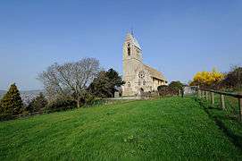
Alongside the manor house lies Selsley Church, commissioned by the Marling family during the mid-19th century and modelled by Bodley in the French Gothic style. Its stained glass was one of the first commissions undertaken by William Morris and his partners Rossetti, Webb, Ford Madox Brown and Burne-Jones. The design of the church derives from the squires' name. The church is modelled on one seen in Marlengo (Marling) in the disputed area of the Italian Tyrol.
Common history
Despite attempts to enclose the common at Selsley, it has been vigorously defended over the years. Indeed, the first recorded dispute was in the Saxon period, and the threat to enclose the common in the 19th century met with vocal public outrage. There is one area which did become enclosed, known locally as 'Dead Man's Acre'. The story goes that a man was told that he could have as much land of the common that he could enclose in one day. The effort though, proved too much, and killed him. The truth of this tale is dubious, as it bears similarities to works of fiction such as Leo Tolstoy's How Much Land Does a Man Need?
Dotted over the common are the long abandoned remains of quarries once used to supply stone for local building and walling. Lesser hollows are the remains of a medieval soldier's camp - so identified in 1942 by Captain H.S. Gracie. In addition, the grassed-over ways used by the quarry wagons can still be seen.
Selsley Common SSSI
| Site of Special Scientific Interest | |
|
Selsley Common | |
| Area of Search | Gloucestershire |
|---|---|
| Grid reference | SO829030 |
| Interest | Biological/Geological |
| Area | 39.4 hectare |
| Notification | 1966 |
| Natural England website | |
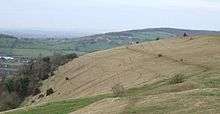
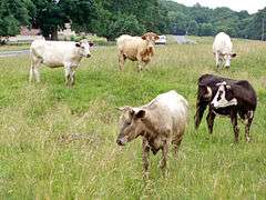
Selsley Common (grid reference SO829030) is a 39.4-hectare (97-acre) biological and geological Site of Special Scientific Interest in Gloucestershire, notified in 1966.[1] It is a large open expanse and a rich habitat for rare flora and fauna. During the summer, bird song mingles with the sound of cattle as commoners can, and still do, exercise grazing rights.
The common is in the Cotswold Area of Outstanding Natural Beauty and overlies the Jurassic limestone of the Cotswolds. It supports herb-rich calcareous grassland habitat. Leigh’s Quarry, which is in the southern part of the SSSI, is of particular geological significance.[1]
The site is listed in the ‘Stroud District’ Local Plan, adopted November 2005, Appendix 6 (online for download) as an SSSI and a Regionally Important Geological Site (RIGS).[2]
Geology
The quarry provides one of the most extensive, and thus significant, cross-sections of the Middle Jurassic Inferior Oolite in the south of the Cotswolds. Oolite Marl, Upper Trigonia Grit and Clypeus Grit are in the succession. This is a site with a notable example of hardground, which is a thin layer of rough limestone formed during environmental changes.[1]
Biology
The grassland is dominated by grasses such as upright brome, sheep's fescue, and there is little tor-grass. The latter makes the common different from others in the region. Herbs include rock-rose, common bird's-foot-trefoil, salad burnet and wild thyme. Orchids are in abundance including autumn lady's tresses, green-winged orchid and fragrant orchid, particularly in the quarry areas. There are scrub areas of hawthorn and there some trees such as ash.[1]
The habitat supports a range of invertebrates including the mollusc Abida secale, and butterflies. The latter include small blue, grayling and Duke of Burgundy fritillary.[1]
References
External links
![]() Media related to Selsley at Wikimedia Commons
Media related to Selsley at Wikimedia Commons
- Natural England (SSSI information)
 Selsley Common
 Quarries on Selsley Common
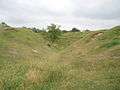 Quarries on Selsley Common
 Selsley Common and Hill
 View of Selsley Common from Rodborough
 View looking to Rodborough
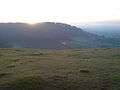 View to Pen Hill
 Orchids on Selsley Common
| Unitary authorities | |
|---|---|
| Boroughs or districts | |
| Major settlements |
|
| Rivers | |
| Topics | |