Shamshabad
| Shamshabad శంషాబాద్ شمس آباد | |
|---|---|
| Mandal | |
|
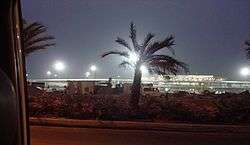
Rajiv Gandhi International Airport at Shamshabad from a distance | |
 Shamshabad  Shamshabad Location in Telangana, India | |
| Coordinates: 17°15′37″N 78°23′49″E / 17.2603°N 78.3969°ECoordinates: 17°15′37″N 78°23′49″E / 17.2603°N 78.3969°E | |
| Country |
|
| State | Telangana, |
| District | Ranga Reddy |
| city | Hyderabad |
| Founded by | Paigah |
| Named for | Shams-ul-Umra |
| Elevation | 574 m (1,883 ft) |
| Demonym(s) | Shamshabadi |
| Languages | |
| • Official | Telugu |
| Time zone | IST (UTC+5:30) |
| PIN | 501218 |
| Vehicle registration | TS-07 |
Shamshabad originally Shamsabad, is a Mandal of Ranga Reddy district in the state of Telangana, India. It is a suburb of the city of Hyderabad.
History
In former times the area was known as Sedanti village, which was later renamed Shamsabad in reference to Shams-ul-Umra, the title bestowed upon "Abul Fateh Khan", Tegh Jung, Shams-ud-Daula, Shams-ul-Mulk and Shams-ul-Umrah ("The Sun among the Nobles"), who founded the Paigah nobility during the reign of Nizam II, Mir Nizam Ali Khan (1762-1803). There was a time when the whole of the Shamsabad area were under the direct control of Paigah, including where the new airport has been built, the entire Shamsabad village was granted to Nawab Shams-ul-Umara Bahadur as a reward. Nawab Moin-ud-Daula Bahadur, a leading Paigah noble, built a country home on a hillock and race course in Shamsabad for his own. As happened with other locality names, Shamsabad too got corrupted and over the years came to be called Shamshabad.
There is a railway station at Shamshabad by the name Umdanagar, which is part of the South Central Railway, Indian Railways.
Geography
Shamshabad is located at 17°15′37″N 78°23′49″E / 17.2603°N 78.3969°E.[1] It has an average elevation of 574 metres (1,886 ft).
Rajiv Gandhi International Airport
Shamshabad boasts the brand-new Rajiv Gandhi International Airport, which commenced operations on March 23, 2008. The airport site totals 5,400-acre (22 km2) in area and the GPS coordinates are 17"15' North and 78"25' East. Currently the biggest project in Hyderabad, the new international airport, will be able to provide much-needed infrastructure to handle large aircraft and the booming passenger and cargo traffic at Hyderabad. With world-class facilities and latest technology aimed at providing passenger convenience, this airport is one of the best in the country. Other noteworthy features of the airport are, the second longest runway (4.2 km or 2.6 miles) in the country, and extensive connectivity to/from the city. This multi-phased project is conceptualised on the lines of modular-expansion and has been developed to cater to over 7 million passengers a year in the first phase i.e. March 2008. It would be able to cater to over 50 million passengers a year in the final phase of development.
Many projects of Telangana Govt. are coming in and around Shamshabad Airport, including Fab City, Nano Tech Park, Hardware Park, and Textile Park. The airport is connected to Hitech City by the Outer Ring Road which makes it very convenient to international visitors visiting the Hitech city.
Panchayats
There are 24 panchayats in the Shamshabad mandal.[2]
- Chinna Golkonda (village and panchayat)
- Chinna Gollapally (village and panchayat)
- Ghansimiyaguda (village and panchayat)
- Hamidullanagar (village and panchayat)
- Jukal (village and panchayat)
- Kacharam (village and panchayat)
- Kavvaguda (village and panchayat)
- Kothwalguda (village and panchayat)
- Madanpally (village and panchayat)
- Malkaram (village and panchayat)
- Muchintal (village and panchayat)
- Nanjapur (village and panchayat)
- Narkhuda (village and panchayat)
- Ootpally (village and panchayat)
- Palamakole (village and panchayat)
- Pedda Golkonda (village and panchayat)
- Pedda Shapur (village and panchayat)
- Pedda Tupra (village and panchayat)
- Ramanujpur (village and panchayat)
- Satamrai (village and panchayat)
- Shamshabad (village and panchayat)
- Shankarapur (village and panchayat)
- Sultanpally (village and panchayat)
- Tondpalli (village and panchayat)
Temples
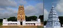
- Seetharamaswamy Temple at Ammapally
Built by Vengi kings in 13th Century AD and one of the rarest Kodanda rama temple, where lord Ram is holding an arrow in his hand along with Sita and Laxmana in the Sanctum sanctorum. Lord Hanuman is placed at the Dhwaja stamba. Temple is located 4 km from Shamshabad bus stand and is one of the popular destinations for the Telugu film industry.
References
- ↑ Falling Rain Genomics.Shamsabad
- ↑ Details of Telangana till Village Panchayat Tier
External links
| Wikimedia Commons has media related to Shamshabad. |