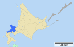
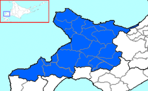
Shiribeshi Subprefecture
| Shiribeshi Subprefecture 後志総合振興局 | |
|---|---|
| Shiribeshi-sōgō-shinkō-kyoku | |
 | |
| Prefecture | Hokkaido |
| Capital | Kutchan |
| Area | |
| • Total | 4,305.82 km2 (1,662.49 sq mi) |
| Population (March 2009) | |
| • Total | 250,065 |
| • Density | 58/km2 (150/sq mi) |
| Website | shiribeshi.pref.hokkaido.lg.jp |
Shiribeshi Subprefecture (後志総合振興局 Shiribeshi-sōgō-shinkō-kyoku) is a subprefecture of Hokkaido Prefecture, Japan. The subprefecture's capital is Kutchan. As of July 31, 2004, the estimated population was 256,184 and the area was 4,305.65 km².
Geography
Cities
Towns and villages by district
- Abuta (Shiribeshi) District
- Furubira District
- Furuu District
- Iwanai District
- Isoya District
- Shakotan District
- Shimamaki District
- Suttsu District
- Yoichi District
Mergers
History
- 1897 Otaru Subprefecture, Iwanai Subprefecture, and Suttsu Subprefecture were established.
- 1899 Kutchan Village (now Kutchan Town and Kyōgoku Town), Abuta District were transferred from Muroran Subprefecture (now Iburi Subprefecture) to Iwanai Subprefecture.
- 1899 Otaru Subprefecture, Iwanai Subprefecture, and Suttsu Subprefecture were merged to form Shiribeshi Subprefecture. Makkari Village (now Makkari Village, Kimobetsu Town, and Rusutsu Village) and Kaributo Village (now Niseko Town), Abuta District were transferred from Muroran Subprefecture.
External links
- (Japanese) Official website in Japanese
42°54′08″N 140°45′24″E / 42.902302°N 140.756583°ECoordinates: 42°54′08″N 140°45′24″E / 42.902302°N 140.756583°E
This article is issued from Wikipedia - version of the 5/25/2015. The text is available under the Creative Commons Attribution/Share Alike but additional terms may apply for the media files.
