Kuromatsunai, Hokkaido
| Kuromatsunai 黒松内町 | |
|---|---|
| Town | |
|
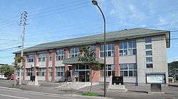
Kuromatsunai Town Hall | |
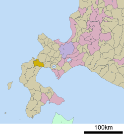 Location of Kuromatsunai in Hokkaido (Shiribeshi Subprefecture) | |
 Kuromatsunai Location in Japan | |
| Coordinates: 42°40′4″N 140°18′27″E / 42.66778°N 140.30750°ECoordinates: 42°40′4″N 140°18′27″E / 42.66778°N 140.30750°E | |
| Country | Japan |
| Region | Hokkaido |
| Prefecture | Hokkaido (Shiribeshi Subprefecture) |
| District | Suttsu |
| Government | |
| • Mayor | Mitsuru Kamata |
| Area | |
| • Total | 345.65 km2 (133.46 sq mi) |
| Population (31 March 2015) | |
| • Total | 3,032 |
| • Density | 8.8/km2 (23/sq mi) |
| Time zone | Japan Standard Time (UTC+9) |
| City hall address |
302-1 Kuromatsunai, Kuromatsunai, Suttsu-gun, Hokkaido 048-0192 |
| Website |
www |
Kuromatsunai (黒松内町 Kuromatsunai-chō) is a town located in Suttsu District, Shiribeshi, Hokkaido, Japan.
As of 31 March 2015 the town had an estimated population of 3,032 and a density of 8.8 persons per km². The total area of the town is 345.65 km².
Geography
Kuromatsunai is located in the southern part of Shiribeshi Subprefecture and while close to both the Sea of Japan and the Pacific Ocean the town itself has no coastline. The Shubetsu River flows through Kuromatsunai.
The town, being the northernmost area of Japan in which beech trees grow naturally, has designated the beech a natural treasure.
Neighboring towns and village
- Shiribeshi Subprefecture
- Iburi Subprefecture
- Oshima Subprefecture
History
- 1902 Kuromatsunai Village becomes a Second Class Village.
- 1915 Neppu Village becomes a Second Class Village.
- 1923 Tarukishi Village becomes a Second Class Village.
- 1955 Kuromatsunai Village, Neppu Village, and a part of Tarukishi Village are merged to form the new village of Miwa.
- 1959 Miwa Village becomes Miwa Town.
- 1959 Miwa is renamed Kuromatsunai.
Transportation
- Hakodate Main Line: Kuromatsunai Station - Neppu Station
- Hokkaido Expressway: Kuromatsunai JCT
- Kuromatsunai Shindo: Kuromatsunai JCT - Kuromatsunai-minami IC - Kuromatsunai IC
- Route 5
Sister city
-
 Seiyo, Ehime (since 1993)[1]
Education
- Junior high schools
- Kuromatsunai Junior High School
- Shiroikawa Junior High School
- Elementary schools
- Kuromatsunai Elementary School
- Shiroikawa Elementary School
References
External links
 Media related to Kuromatsunai, Hokkaidō at Wikimedia Commons
- Official website (Japanese)
This article is issued from Wikipedia - version of the 3/17/2016. The text is available under the Creative Commons Attribution/Share Alike but additional terms may apply for the media files.