Asahikawa, Hokkaido
| Asahikawa 旭川市 | ||
|---|---|---|
| Core city | ||
| ||
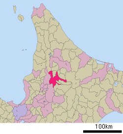 Location of Asahikawa in Kamikawa Subprefecture, Hokkaido | ||
 Location of Kamikawa Subprefecture in Hokkaido | ||
 Asahikawa Location in Japan | ||
| Coordinates: 43°46′N 142°22′E / 43.767°N 142.367°ECoordinates: 43°46′N 142°22′E / 43.767°N 142.367°E | ||
| Country | Japan | |
| Region | Hokkaido | |
| Prefecture | Hokkaido | |
| Government | ||
| • Mayor | Masahito Nishikawa | |
| Area | ||
| • Total | 747.6 km2 (288.6 sq mi) | |
| Population (July 30, 2011) | ||
| • Total | 352,105 | |
| • Density | 470.98/km2 (1,219.8/sq mi) | |
| Symbols | ||
| • Tree | Japanese rowan | |
| • Flower | Azalea | |
| • Bird | Bohemian waxwing | |
| • Others | Insect: Kantan (Oecanthus longicauda) | |
| Time zone | Japan Standard Time (UTC+9) | |
| City hall address |
9-46 Rokujō-dōri, Asahikawa-shi, Hokkaido 070-8525 | |
| Website |
www | |

Asahikawa (旭川市 Asahikawa-shi) is a city in Kamikawa Subprefecture, Hokkaido, Japan. It is the capital of the subprefecture and the second-largest city in Hokkaido, after Sapporo.[1][2] It has been a core city since April 1, 2000. The city is currently well known for the Asahiyama Zoo and Asahikawa ramen.
On July 31, 2011, the city had an estimated population of 352,105, with 173,961 households and a population density of 470.96 persons per km² (1,219.8 persons per sq. mi.). The total area is 747.6 km2 (288.6 sq mi).[2]
Name
The Ainu called the Asahi River Chiu Pet meaning "River of Waves", but it was misunderstood as Chup Pet meaning "Sun River", and so it came to be called Asahi River in Japanese (Asahi meaning "morning sun").
Overview
On August 1, 1922, Asahikawa was founded as Asahikawa City. As the central city in northern Hokkaido, Asahikawa has been influential in industry and commerce. There are about 130 rivers and streams including the Ishikari River and Chūbetsu River, and over 740 bridges in the city.[3] Asahibashi, a bridge over Ishikari River, has been one of the symbols of Asahikawa since its completion in 1932, and it was also registered as one of the Hokkaido Heritage sites on October 22, 2001.[4]

Every winter, the Asahikawa Winter Festival is held on the bank of the Ishikari River, making use of Asahikawa's cold climate and snow. On January 25, 1902, a weather station recorded −41 °C (−41.8 °F), the lowest temperature in Japanese history.[5] Due to its climate and location surrounded by mountains, there are some ski resorts in the outskirts of the city.

History
Asahikawa was populated by mainland Japanese in the Meiji period (1868 – July 1912) as a tondenhei, or state-sponsored farmer-militia settlement.[1]
Kamikawa District set up under Ishikari Province with the villages of Asahikawa, Nagayama and Kamui in 1890.
Asahikawa was elevated to city status in 1922.[2]
Asahikawa thrived as a military city before World War II, when the IJA 7th Division was posted there. Today, the 2nd Division of the Northern Army of the Japan Ground Self-Defense Force is headquartered in Asahikawa.
- 1955 Kamui Village and Etanbetsu Village merge with Asahikawa
- 1961 Nagayama Town merged
- 1963 Higashi-Asahikawa Town merged
- 1967 Asahiyama Zoo opened
- 1968 Kagura Town merged
- 1971 Higashi-Takasu Town merged
- 1972 Japan's first permanent pedestrian mall Heiwadōri Shopping Park opened
- April 1, 2000 Asahikawa becomes a Core city
Climate
According to the Köppen climate classification, Asahikawa features a humid continental climate (Dfb) with warm summers and cold and snowy winters. Asahikawa winters are long and cold, with average monthly temperatures from December through March failing to transcend the freezing point. The city also sees an extraordinary amount of snowfall, averaging just under 7.6 m (25 ft) of snow per year. Summers are generally warm and humid in Asahikawa, with average high temperatures in the warmest months hovering around 26 °C (79 °F). Spring and fall are generally short and transitional in the city.
| Climate data for Asahikawa, Hokkaido (1981–2010) | |||||||||||||
|---|---|---|---|---|---|---|---|---|---|---|---|---|---|
| Month | Jan | Feb | Mar | Apr | May | Jun | Jul | Aug | Sep | Oct | Nov | Dec | Year |
| Record high °C (°F) | 11.7 (53.1) |
12.2 (54) |
18.8 (65.8) |
29.6 (85.3) |
32.8 (91) |
35.9 (96.6) |
35.0 (95) |
36.0 (96.8) |
32.9 (91.2) |
25.0 (77) |
22.0 (71.6) |
14.7 (58.5) |
36.0 (96.8) |
| Average high °C (°F) | −3.5 (25.7) |
−2.1 (28.2) |
2.6 (36.7) |
11.7 (53.1) |
17.7 (63.9) |
22.9 (73.2) |
25.8 (78.4) |
26.3 (79.3) |
21.6 (70.9) |
14.8 (58.6) |
5.8 (42.4) |
−0.8 (30.6) |
11.9 (53.4) |
| Daily mean °C (°F) | −7.5 (18.5) |
−6.5 (20.3) |
−1.8 (28.8) |
5.6 (42.1) |
11.8 (53.2) |
16.5 (61.7) |
20.2 (68.4) |
21.1 (70) |
15.9 (60.6) |
9.2 (48.6) |
1.9 (35.4) |
−4.3 (24.3) |
6.84 (44.33) |
| Average low °C (°F) | −12.3 (9.9) |
−12.7 (9.1) |
−6.3 (20.7) |
0.0 (32) |
5.4 (41.7) |
11.6 (52.9) |
15.9 (60.6) |
16.8 (62.2) |
11.2 (52.2) |
3.9 (39) |
−2 (28) |
−7.9 (17.8) |
2.0 (35.6) |
| Record low °C (°F) | −41 (−42) |
−38.3 (−36.9) |
−34.1 (−29.4) |
−19 (−2) |
−7.1 (19.2) |
−1.2 (29.8) |
1.0 (33.8) |
2.4 (36.3) |
−1.8 (28.8) |
−8 (18) |
−25 (−13) |
−30 (−22) |
−41 (−42) |
| Average precipitation mm (inches) | 69.6 (2.74) |
51.3 (2.02) |
54.0 (2.126) |
47.6 (1.874) |
64.8 (2.551) |
63.6 (2.504) |
108.7 (4.28) |
133.5 (5.256) |
130.9 (5.154) |
104.3 (4.106) |
117.2 (4.614) |
96.6 (3.803) |
1,042.1 (41.028) |
| Average snowfall cm (inches) | 174 (68.5) |
131 (51.6) |
111 (43.7) |
23 (9.1) |
0 (0) |
0 (0) |
0 (0) |
0 (0) |
0 (0) |
3 (1.2) |
107 (42.1) |
189 (74.4) |
743 (292.5) |
| Average snowy days | 30.4 | 26.8 | 25.1 | 9.4 | 0.7 | 0 | 0 | 0 | 0 | 2.9 | 17.7 | 29.3 | 142.3 |
| Average relative humidity (%) | 80 | 79 | 69 | 67 | 66 | 74 | 78 | 79 | 77 | 78 | 81 | 82 | 76 |
| Mean monthly sunshine hours | 73.8 | 105.8 | 149.6 | 167.1 | 197.6 | 189.3 | 161.8 | 147.3 | 142.2 | 132.0 | 64.0 | 60.3 | 1,590.8 |
| Source #1: Japan Meteorological Agency[6] | |||||||||||||
| Source #2: Japan Meteorological Agency[7] | |||||||||||||
Economy
Asahikawa developed as an industrial center in Hokkaido after World War II. The city is noted for its lumber and brewing industries, as well as the production of furniture and paper pulp.[1]
Education
Universities
National
- Asahikawa Medical University
- Hokkaido University of Education, Asahikawa Campus
Private
- Asahikawa University
- Tokai University (Previously: the Asahikawa Campus of Hokkaido Tokai University[8])
Colleges
- Asahikawa National College of Technology
High schools
Public
- Hokkaido Asahikawa Higashi High school
- Hokkaido Asahikawa Kita High School
- Hokkaido Asahikawa Nishi High School
- Hokkaido Asahikawa Minami High School
- Hokkaido Asahikawa Ryoun High School
- Hokkaido Asahikawa Toei High School
- Hokkaido Asahikawa Agricultural High School
- Hokkaido Asahikawa Commercial High School (Shogyo)
- Hokkaido Asahikawa Technical High School
Private
- Asahikawa Ryukoku High School
- Asahikawa Fuji Girls' High School
- Asahikawa Jitsugyo High School
- Asahikawa Meisei High School
- Asahikawa University High School
- Ikegami Gakuen High School, Asahikawa Campus
Transportation
Airport
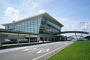
Asahikawa is served by Asahikawa Airport which stretches over the outskirts of Asahikawa City and Higashikagura, Hokkaido. The airport was first proposed by the Asahikawa City Council in 1955, opened in 1961, and daily flights to Tokyo started in 1970. The present terminal of Asahikawa Airport opened in 2000. It is a second class airport, and also a single-runway regional airport. It serves domestic destinations including Tokyo, but some airlines offer destinations in South Korea.[9] EVA Air added Asahikawa as a destination from Taipei on May 2, 2013.
Rail
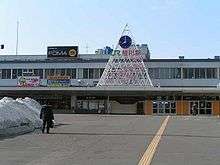
Asahikawa is one of the major rail hubs of Hokkaido. The Hakodate Main Line connects Asahikawa to Hakodate in the south of Hokkaido, and the Sōya Main Line connects Asahikawa with Wakkanai at the north of Hokkaido. The Sekihoku Main Line connects the city with Abashiri on the Sea of Okhotsk. The Furano Line connects Abashiri with nearby Furano.[2]
- Hakodate Main Line : Asahikawa Chikabumi - Inō
- Sōya Main Line : Asahikawa - Asahikawa-Yojō - Shin-Asahikawa - Nagayama - Kita-Nagayama
- Sekihoku Main Line : Shin-Asahikawa - Minami-Nagayama - Higashi-Asahikawa - Kita-Hinode - Sakuraoka
- Furano Line : Asahikawa - Kaguraoka - Midorigaoka - Nishi-Goryō - Nishi-Mizuho - Nishi-Kagura - Nishi-Seiwa - Chiyogaoka
Bus
Municipal buses also serve the city.
Specialties
- Asahikawa Ramen
- Asahikawa furniture
- Confectionery
- Sake (Otokoyama, Takasago, Taisetsunokura)
- Cocktail
- Taisetsu Microbrew Beer "Taisetsu ji-beer"
- Asahikawa mutton barbecue "Genghis Khan"
- Pottery / Wooden handiwork (Arashiyama area)
Sightseeing

- Arashiyama Pottery village
- Asahibashi Bridge
- Asahikawa Furniture Center
- Asahikawa Museum of Sculpture in Honor of Teijiro Nakahara
- Asahikawa Winter Festival / Illuminations (February)
- Asahikawa Youth Science Museum "Saiparu"
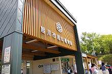
- Asahiyama Zoo
- Ayako Miura Memorial Literature Center
- Hoppo Wild Flower Garden, famous for Erythronium japonicum (Dogtooth violet) that flower in May
- Hokkaido Traditional Art Craft Village
- Kita-no-Mori Ice Pavilion
- Mount Tossho, also famous for Erythronium japonicum
- Otokoyama Sake Brewing Museum
- Romantic Road (tree tunnel and churches)
- Ski Resorts (Kamui Ski Links, Santa Present Park, Pippu Ski Area, Canmore Ski Village etc.)
- Sugai Amusement Factory
- Yasushi Inoue Memorial Center
Sister and friendship cities
Sister cities
 Bloomington, Illinois, United States[10]
 - Normal, Illinois, United States
 Suwon, South Korea
Friendship cities
 Yuzhno-Sakhalinsk, Sakhalin Oblast, Russia
 Harbin, Heilongjiang, China
Notable people
- Takeshi Aono, voice actor (deceased)
- Miura Ayako, author
- Yuko Emoto, judo wrestler
- Yasushi Inoue, author
- Kiyomi Kato, wrestler
- Shigeo Nakata, wrestler
- Ikumi Narita, volleyball player
- Victor Starffin, baseball player
- Taizō Sugimura, politician
- Kentaro Suzuki, football player
- Tomoka Takeuchi, snowboarder
- Kōji Tamaki, lead vocalist of Anzen Chitai
- Buichi Terasawa, manga artist
- Masae Ueno, judo wrestler
- Yoshie Ueno, judo wrestler
- Miho Yabe, actress
- Shōgō Yasumura, comedian
References
- 1 2 3 "Asahikawa". Encyclopedia of Japan. Tokyo: Shogakukan. 2013. OCLC 56431036. Archived from the original on 2007-08-25. Retrieved 2013-11-19.
- 1 2 3 4 "旭川市" [Asahikawa]. Nihon Rekishi Chimei Taikei (in Japanese). Tokyo: Shogakukan. 2013. OCLC 173191044. Archived from the original on 2007-08-25. Retrieved 2013-11-19.
- ↑ Asahikawa 8 Scenes (Japanese)
- ↑ Hokkaido Heritage Website: 6, Asahibashi Bridge (Japanese)
- ↑ Asahikawa City 7th General Scheme Gist (Japanese)
- ↑ "平年値(年・月ごとの値)". Japan Meteorological Agency. Retrieved 2010-02-22.
- ↑ "観測史上1〜10位の値(年間を通じての値)". Japan Meteorological Agency. Retrieved 2010-02-22.
- ↑ "DIRECTIONS TO HOKKAIDO TOKAI UNIVERSITY (HTU)" (). Hokkaido Tokai University. November 20, 2005. Retrieved on April 10, 2015. "5-1-1-1 Minami-sawa, Minami-ku, Sapporo 005-8601, Japan" and "224 Chuwa, Kamui-Cho, Asahikawa 070-8601, Hokkaido, Japan"
- ↑ "旭川空港" [Asahikawa Airport]. Nihon Rekishi Chimei Taikei (in Japanese). Tokyo: Shogakukan. 2013. OCLC 173191044. Archived from the original on 2007-08-25. Retrieved 2013-11-19.
- ↑ "Interactive City Directory". Sister Cities International. Retrieved 11 March 2014.
External links
| Wikimedia Commons has media related to Asahikawa, Hokkaido. |
 Asahikawa travel guide from Wikivoyage
- Asahikawa Travel Information in English
- Official website (Japanese)
- Taisetsu sightseeing navigation(Korean)
- Asahikawa Winter Festival information in English