Kitami, Hokkaido
| Kitami 北見市 | ||
|---|---|---|
| City | ||
|
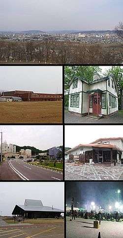
Clockwise from top: View of downtown Kitami from Southhill Forest Park, Pierson Memorial Museum, Takinoyu Spa, Kitami BBQ Festival in February, Wakka Nature Center, Street in Onneyu area, Kitami Municipal Curling Arena | ||
| ||
 Location of Kitami in Hokkaido (Okhotsk Subprefecture) | ||
 Kitami Location in Japan | ||
| Coordinates: 43°48′N 143°54′E / 43.800°N 143.900°ECoordinates: 43°48′N 143°54′E / 43.800°N 143.900°E | ||
| Country | Japan | |
| Region | Hokkaido | |
| Prefecture | Hokkaido (Okhotsk Subprefecture) | |
| Government | ||
| • Mayor | Makoto Sakurada | |
| Area | ||
| • Total | 1,427.56 km2 (551.18 sq mi) | |
| Population (March 1, 2012) | ||
| • Total | 124,789 | |
| • Density | 87.55/km2 (226.8/sq mi) | |
| Symbols | ||
| • Tree | Japanese Yew | |
| • Flower | Chrysanthemum | |
| Time zone | Japan Standard Time (UTC+9) | |
| City hall address |
1 Higashi Ni-chōme, Kita Go-jō, Kitami-shi, Hokkaido 090-8501 | |
| Website |
www | |

Kitami (北見市 Kitami-shi) is a city in Okhotsk Subprefecture, Hokkaido, Japan. It is the most populous city and the commercial center in the subprefecture, although the subprefectural capital is Abashiri.
Kitami is in central Okhotsk Subprefecture. The Kitami Mountains are nearby.
As of March 1, 2012, the city has a population of 124,789, with 60,646 households, and a population density of 87.55 persons per km². The total area is 1,427.56 km2 (551.18 sq mi).
History
- 1872: The village of Notsukeushi-mura (ノツケウシ村) founded
- 1875: Notsukeushi-mura was given the kanji 野付牛村.
- 1910: Train service arrives (then called the Ikeda Railway Line), connecting the village to Sapporo.[1]
- 1915: The villages of Rubeshibe and Oketo were split off.
- 1916: Became Notsukeushi Town.
- 1921: The villages of Tanno and Ainonai were split off.
- June 10, 1942: Kitami becomes a city.
- September 1956: The village of Ainonai was merged into Kitami.
- March 5, 2006: The towns of Rubeshibe, Tanno and Tokoro (all from Tokoro District) merged with the city of Kitami to form the new city of Kitami.
Economy and industry
Kitami at one time exported mint (known as hakka locally), supplying 70% of the world's mint consumption.[2][3]
Education
Kitami is home to the Kitami Institute of Technology, an engineering university that originally opened in 1960,[4] and the Japanese Red Cross Hokkaido College of Nursing, established in 1999 by the Japanese Red Cross through consolidation of several other institutions.[5]
Universities
National
Private
High Schools
Public
- Hokkaido Kitami Hokuto High School
- Hokkaido Kitami Hakuyou High School
- Hokkaido Kitami Ryokuryo High School
- Hokkaido Kitami Commercial High School
- Hokkaido Kitami Technical High School
- Hokkaido Rubeshibe High School
- Hokkaido Tokoro High School
Private
- Kitami Fuji Girls' High School
Festivals
- The Kitami Winter Festival, held annually during the 2nd week of February.[6]
- The Kitami Bonchi Festival (Summer Festival) in early July.[7]
- The Kitami Chrysanthemum festival in Mid October−early November.[8]
Sports
Curling
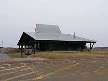
The city has strong associations with the sport of curling, inherited from the former town of Tokoro absorbed into the city in 2006. Interest in the sport grew following a friendship visit in 1980 by a curling team from Alberta in Canada.[9] An outdoor curling rink was built in Tokoro the following year, and it hosted the 1st NHK Cup Curling Championship.[9] In January 1988, the town built a dedicated 5-lane curling hall, the first in Japan.[10] This eventually closed in early 2013, replaced by a new, larger, all-year-round structure.[10]
Curling was introduced in schools in Tokoro as part of the physical education curriculum, and the two produced a number of Olympic curlers.[9] Five members of the Japanese curling team at the 1998 Winter Olympics in Nagano were from Tokoro, three members of the Japanese curling team at the 2006 Winter Olympics in Torino were from Tokoro, and three members of the Japanese curling team at the 2010 Winter Olympics in Vancouver were from Tokoro.[9]
Climate
Kitami has a humid continental climate with cold winters and relatively warm summers. The coldest month is January, with an average low of −14.7 °C (5.5 °F), and the warmest month is August, with an average high of 25 °C (77 °F) and a record high of 37 °C (99 °F). Kitami's inland location creates a larger temperature range than some coastal cities. Due to the mountains nearby, the Foehn wind effect occurs in summer when prevailing winds are from the southeast, so that Kitami often has the hottest temperatures in Hokkaido during this season and averages about 5 °C (9 °F) hotter than Kushiro. Traces of snow fall every day during the winter and cover is heavy, usually peaking at 0.82 metres (32.28 in), though Kitami still receives less overall precipitation than any other town in Japan as it is shielded from the heaviest moisture from both the Sea of Japan and Pacific Ocean.
| Climate data for Kitami, Hokkaido (1981–2010) | |||||||||||||
|---|---|---|---|---|---|---|---|---|---|---|---|---|---|
| Month | Jan | Feb | Mar | Apr | May | Jun | Jul | Aug | Sep | Oct | Nov | Dec | Year |
| Record high °C (°F) | 8.0 (46.4) |
7.9 (46.2) |
15.1 (59.2) |
32.2 (90) |
33.9 (93) |
34.2 (93.6) |
35.9 (96.6) |
37.0 (98.6) |
32.1 (89.8) |
27.7 (81.9) |
22.0 (71.6) |
14.5 (58.1) |
37.0 (98.6) |
| Average high °C (°F) | −2.9 (26.8) |
−1.9 (28.6) |
2.9 (37.2) |
11.3 (52.3) |
17.6 (63.7) |
21.2 (70.2) |
24.3 (75.7) |
25.7 (78.3) |
21.3 (70.3) |
15.4 (59.7) |
7.5 (45.5) |
0.1 (32.2) |
11.9 (53.4) |
| Daily mean °C (°F) | −8.5 (16.7) |
−7.8 (18) |
−2.4 (27.7) |
5.0 (41) |
10.9 (51.6) |
15.0 (59) |
18.7 (65.7) |
20.2 (68.4) |
15.8 (60.4) |
9.1 (48.4) |
2.1 (35.8) |
−5.0 (23) |
6.1 (43) |
| Average low °C (°F) | −14.7 (5.5) |
−14.1 (6.6) |
−8.1 (17.4) |
−0.7 (30.7) |
4.7 (40.5) |
9.7 (49.5) |
14.1 (57.4) |
15.8 (60.4) |
10.6 (51.1) |
3.4 (38.1) |
−2.9 (26.8) |
−10.6 (12.9) |
0.6 (33.1) |
| Record low °C (°F) | −30.1 (−22.2) |
−30.9 (−23.6) |
−24.3 (−11.7) |
−14 (7) |
−4.8 (23.4) |
−0.9 (30.4) |
3.4 (38.1) |
6.3 (43.3) |
0.3 (32.5) |
−4.6 (23.7) |
−16.3 (2.7) |
−24.6 (−12.3) |
−30.9 (−23.6) |
| Average precipitation mm (inches) | 47.5 (1.87) |
32.4 (1.276) |
42.5 (1.673) |
47.6 (1.874) |
56.7 (2.232) |
57.3 (2.256) |
94.0 (3.701) |
113.2 (4.457) |
106.3 (4.185) |
69.0 (2.717) |
43.9 (1.728) |
49.4 (1.945) |
759.8 (29.914) |
| Average snowfall cm (inches) | 119 (46.9) |
97 (38.2) |
101 (39.8) |
29 (11.4) |
3 (1.2) |
0 (0) |
0 (0) |
0 (0) |
0 (0) |
0 (0) |
17 (6.7) |
87 (34.3) |
453 (178.5) |
| Average precipitation days (≥ 1.0 mm) | 11.4 | 9.6 | 11.2 | 10.1 | 9.9 | 9.0 | 10.6 | 10.2 | 10.6 | 9.1 | 9.4 | 10.8 | 121.9 |
| Average snowy days (≥ 5 cm) | 30.9 | 28.2 | 29.4 | 6.3 | 0.1 | 0 | 0 | 0 | 0 | 0 | 1.6 | 20.1 | 116.6 |
| Mean monthly sunshine hours | 114.7 | 128.6 | 166.4 | 164.9 | 179.6 | 167.7 | 154.7 | 155.3 | 145.3 | 155.0 | 129.7 | 115.6 | 1,777.5 |
| Source #1: Japan Meteorological Agency[11] | |||||||||||||
| Source #2: Japan Meteorological Agency[12] | |||||||||||||
Transportation
Road
National Route 39 passes through Kitami.
Bus
The Hokkaido Kitami Bus Company has a number of inter-city as well as out-of-city routes.[13]
Rail
The JR Hokkaido Sekihoku Main Line that passes through Kitami reached the city on October 19, 1910 when the town was still called Notsukeushi. The largest station is Kitami Station, with Nishi-Kitami Station, Hakuyo Station, and Itoshino Station also located in Kitami.
Air
The city is served by Memanbetsu Airport in the neighboring town of Ōzora.
Sister cities
 Elizabeth, New Jersey, United States. Signed on June 12, 1969.[14]
 Poronaysk, Sakhalin Oblast, Russia. Signed on August 13, 1972.
 Jinju, South Korea
 Barrhead, Alberta, Canada (Barrhead Town had a relationship with the former town of Tokoro. In 2006, Tokoro merged into Kitami city so Kitami takes over the relationship.)
 Kōchi, Kōchi, Japan
- Sakawa, Kochi, Japan
- Marumori, Miyagi, Japan
- Ono, Gifu, Japan
Notes
- ↑ "The Inconvenient Journey between Sapporo and Nokkeushi−the Opening of the Ikeda Railway Line". city.kitami.lg.jp. City of Kitami. Retrieved 2011-05-29.
- ↑ "Kitami Mint Commemoration Hall Mint Distillation Hall". kitamikanko.jp. Kitami Tourism. Retrieved 2011-05-29.
- ↑ "Peppermint Era Inns". city.kitami.lg.jp. City of Kitami. Retrieved 2011-05-29.
- ↑ "Facts about the Kitami Institute of Technology". kitami-it.ac.jp. National University Corporation. Retrieved 29 May 2011.
- ↑ "History". rchokkaido-cn.ac.jp. Japanese Red Cross Hokkaido College of Nursing. Retrieved 2011-05-29.
- ↑ "Kitami Winter Festival". kitamikanko.jp. Kitami Tourism. Retrieved 2011-05-29.
- ↑ "Kitami Bonchi Festival". kitamikanko.jp. Kitami Tourism. Retrieved 2011-05-29.
- ↑ "Kitami Chrysanthemum Festival". kitamikanko.jp. Kitami Tourism. Retrieved 2011-05-29.
- 1 2 3 4 "Curling" (in Japanese). Japan: City of Kitakami. Retrieved 1 February 2014.
- 1 2 常呂町カーリングホール 今季限り [Tokoro Curling Hall to close at the end of this season]. Asahi Shimbun Digital (in Japanese). Japan: The Asahi Shimbun Company. 29 January 2013. Retrieved 1 February 2014.
- ↑ "平年値(年・月ごとの値)". Japan Meteorological Agency. Retrieved 2010-03-17.
- ↑ "観測史上1~10位の値(年間を通じての値)". Japan Meteorological Agency. Retrieved 2010-03-17.
- ↑ "Hokkaido Kitami Bus Company Inc.". h-kitamibus.co.jp. Hokkaido Kitami Bus Company Inc. Retrieved 2011-05-27.
- ↑ "Sister Cities and States". sapporo.usconsulate.gov. U.S. Department of State. Retrieved 2011-05-29.
References
- "Selected Essays on the History of Kitami City, Hokkaido, Japan". city.kitami.lg.jp. City of Kitami. Retrieved 2011-05-29.
External links
| Wikimedia Commons has media related to Kitami, Hokkaido. |
-
 Kitami travel guide from Wikivoyage
 - Official website