Singleton Council
| Singleton Council New South Wales | |||||||||||||
|---|---|---|---|---|---|---|---|---|---|---|---|---|---|
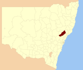 Location in New South Wales | |||||||||||||
| Coordinates | 32°34′S 151°10′E / 32.567°S 151.167°ECoordinates: 32°34′S 151°10′E / 32.567°S 151.167°E | ||||||||||||
| Population | 24,071 (2015 Est.)[1] | ||||||||||||
| • Density | 4.92/km2 (12.7/sq mi) | ||||||||||||
| Area | 4,893 km2 (1,889.2 sq mi)[2] | ||||||||||||
| Time zone | AEST (UTC+10) | ||||||||||||
| • Summer (DST) | AEDT (UTC+11) | ||||||||||||
| Mayor | Cr Sue Moore [3] | ||||||||||||
| Council seat | Singleton[4] | ||||||||||||
| Region | Hunter[5] | ||||||||||||
| State electorate(s) | |||||||||||||
| Federal Division(s) | Hunter[8] | ||||||||||||
 | |||||||||||||
| Website | Singleton Council | ||||||||||||
| |||||||||||||
Singleton Council is a local government area in the Hunter Region of New South Wales, Australia. It is situated adjacent to the New England Highway and the Hunter railway line.
The mayor of the Council is Cr. Sue Moore, an independent politician.[3]
Main towns and villages
The Council area includes Singleton, Broke, Bulga, Howes Valley, Putty, Warkworth, Jerrys Plains, Camberwell, Ravensworth, Mount Olive, Carrowbrook, Mirranie, Elderslie, Belford and Branxton.
Demographics
At the 2011 census, there were 22,694 people in the Singleton Council local government area, of these 51.3 per cent were male and 48.7 per cent were female. Aboriginal and Torres Strait Islander people made up 3.7 per cent of the population, which was higher than the national and state averages of 2.5 per cent. The median age of people in the Singleton Council area was 35 years, which was slightly lower than the national median of 37 years. Children aged 0 – 14 years made up 22.2 per cent of the population and people aged 65 years and over made up 10.4 per cent of the population. Of people in the area aged 15 years and over, 51.5 per cent were married and 10.5 per cent were either divorced or separated.[2]
Population growth in the Singleton Council area between the 2001 census and the 2006 census was 8.12 per cent; and in the subsequent five years to the 2011 census, population growth was 3.45 per cent. When compared with total population growth of Australia for the same periods, being 5.78 per cent and 8.32 per cent respectively, population growth in the Singleton Council local government area was slightly lower than the national average.[9][10] The median weekly income for residents within the Singleton Council area was marginally higher than the national average.[2]
At the 2011 census, the proportion of residents in the Singleton Council local government area who stated their ancestry as Australian or Anglo-Saxon exceeded 83 per cent of all residents (national average was 65.2 per cent). In excess of 69% of all residents in the Singleton Council area nominated a religious affiliation with Christianity at the 2011 census, which was significantly higher than the national average of 50.2 per cent. Meanwhile, as at the census date, compared to the national average, households in the Singleton Council local government area had a significantly lower than average proportion (4.0 per cent) where two or more languages are spoken (national average was 20.4 per cent); and a significantly higher proportion (93.5 per cent) where English only was spoken at home (national average was 76.8 per cent).[2]
| Selected historical census data for the Singleton Council local government area | |||||
|---|---|---|---|---|---|
| Census year | 2001[9] | 2006[10] | 2011[2] | ||
| Population | Estimated residents on Census night | 20,290 | 21,937 | 22,694 | |
| LGA rank in terms of size within New South Wales | |||||
| % of New South Wales population | 0.33% | ||||
| % of Australian population | 0.11% | ||||
| Cultural and language diversity | |||||
| Ancestry, top responses | Australian | 36.8% | |||
| English | 31.5% | ||||
| Irish | 7.8% | ||||
| Scottish | 7.3% | ||||
| German | 3.6% | ||||
| Language, top responses (other than English) | Afrikaans | n/c | |||
| German | 0.1% | ||||
| Italian | n/c | ||||
| Filipino | 0.1% | ||||
| Cantonese | n/c | ||||
| Religious affiliation | |||||
| Religious affiliation, top responses | Anglican | 38.6% | |||
| Catholic | 26.3% | ||||
| No Religion | 9.2% | ||||
| Uniting Church | 7.5% | ||||
| Presbyterian and Reformed | 3.2% | ||||
| Median weekly incomes | |||||
| Personal income | Median weekly personal income | A$487 | A$640 | ||
| % of Australian median income | 104.5% | ||||
| Family income | Median weekly family income | A$1,458 | A$1,927 | ||
| % of Australian median income | 124.5% | ||||
| Household income | Median weekly household income | A$1,258 | A$1,692 | ||
| % of Australian median income | 122.5% | ||||
Council
Current composition and election method
Singleton Council is composed of ten councillors, including the mayor, for a fixed four-year term of office. The mayor is directly elected while the nine other councillors are elected proportionally as one entire ward. The most recent election was held on 10 September 2016, and the makeup of the Council, including the mayor, is as follows:[3][11]
| Party | Councillors | |
|---|---|---|
| Independents and Unaligned | 9 | |
| Australian Labor Party | 1 | |
| Total | 10 | |
The current Council, elected in 2016, in order of election by ward, is:[11]
| Councillor | Party | Notes | |
|---|---|---|---|
| Sue Moore | Independent | Mayor[3] | |
| Danny Thompson | Independent | ||
| Tony Jarrett | Australian Labor Party | ||
| Tony McNamara | Independent | ||
| John Martin | Unaligned | ||
| Val Scott | Unaligned | ||
| Godfrey Adamthwaite | Independent | ||
| Sue George | Independent | ||
| Sarah Lukeman | Independent | ||
| Hollee Jenkins | Independent | ||
References
- ↑ "3218.0 – Regional Population Growth, Australia, 2014–15". Australian Bureau of Statistics. Retrieved 29 September 2016.
- 1 2 3 4 5 Australian Bureau of Statistics (31 October 2012). "Singleton (Local Government Area)". 2011 Census QuickStats. Retrieved 10 September 2012.
- 1 2 3 4 "Singleton Council – Mayoral Election". Local Government Elections 2016. Electoral Commission of New South Wales. 19 September 2016. Retrieved 19 October 2016.
- ↑ "Council Search – Singleton Council". New South Wales Division of Local Government. Retrieved 10 October 2012.
- ↑ "Suburb Search – Local Council Boundaries – Hunter (HT) – Singleton Council". New South Wales Division of Local Government. Retrieved 10 October 2012.
- ↑ "Upper Hunter". New South Wales Electoral Commission. 24 September 2012. Retrieved 10 October 2012.
- ↑ "Cessnock". New South Wales Electoral Commission. 24 September 2012. Retrieved 10 October 2012.
- ↑ "Hunter". Australian Electoral Commission. 26 July 2012. Retrieved 10 October 2012.
- 1 2 Australian Bureau of Statistics (9 March 2006). "Singleton (A)". 2001 Census QuickStats. Retrieved 23 December 2013.
- 1 2 Australian Bureau of Statistics (25 October 2007). "Singleton (A)". 2006 Census QuickStats. Retrieved 23 December 2013.
- 1 2 "Singleton Council: Summary of First Preference Votes for each Candidate". Local Government Elections 2012. Electoral Commission of New South Wales. 19 September 2016. Retrieved 19 October 2016.