Slickville Historic District
|
Slickville Historic District | |
|
First Avenue in Slickville, HABS Photo, April 1990 | |
  | |
| Location | Roughly bounded by Greenburg and Second Ave. and Delmont, Court, Cottage and Fred Sts., Salem Township, Pennsylvania |
|---|---|
| Coordinates | 40°27′27″N 79°31′23″W / 40.45750°N 79.52306°WCoordinates: 40°27′27″N 79°31′23″W / 40.45750°N 79.52306°W |
| Area | 62 acres (25 ha) |
| Built | 1916-1923 |
| Built by | Tressler, Thomas; Truxall, J.A. |
| Architectural style | Other, Company Housing |
| MPS | Bituminous Coal and Coke Resources of Pennsylvania MPS |
| NRHP Reference # | 94000522[1] |
| Added to NRHP | June 3, 1994 |
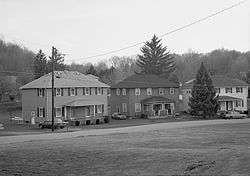
Slickville Historic District is a national historic district located at Salem Township, Westmoreland County, Pennsylvania. It encompasses 90 contributing buildings and 1 contributing structure in the unincorporated village of Slickville. The company built mining town was built between 1916 and 1923. The contributing resources include workers and managers housing, four utilitarian mine-related buildings, a church, a school, a pump house, and a company store. The community was originally developed by the Cambria Steel Company, and later acquired by Bethlehem Steel who operated Slick Mine No. 91 after 1923.[2]
It was added to the National Register of Historic Places in 1994.[1]
References
- 1 2 National Park Service (2010-07-09). "National Register Information System". National Register of Historic Places. National Park Service.
- ↑ "National Historic Landmarks & National Register of Historic Places in Pennsylvania" (Searchable database). CRGIS: Cultural Resources Geographic Information System. Note: This includes Carmen DiCiccio (January 1994). "National Register of Historic Places Inventory Nomination Form: Slickville Historic District" (PDF). Retrieved 2012-06-16.
External links
- Historic American Engineering Record (HAER) No. PA-256, "Town of Slickville", 2 photos, 5 data pages, 1 photo caption page
| Topics |   | |
|---|---|---|
| Lists by county |
| |
| Lists by city | ||
| Other lists | ||
| ||
This article is issued from Wikipedia - version of the 11/29/2016. The text is available under the Creative Commons Attribution/Share Alike but additional terms may apply for the media files.