Songoua
| Songoua | |
|---|---|
| Commune | |
 Songoua Location in Mali | |
| Coordinates: 12°30′50″N 5°28′40″W / 12.51389°N 5.47778°WCoordinates: 12°30′50″N 5°28′40″W / 12.51389°N 5.47778°W | |
| Country |
|
| Region | Sikasso Region |
| Cercle | Koutiala Cercle |
| Area[1] | |
| • Total | 107 km2 (41 sq mi) |
| Population (2009)[2] | |
| • Total | 6,918 |
| • Density | 65/km2 (170/sq mi) |
| Time zone | GMT (UTC+0) |
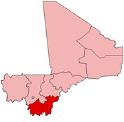
Songoua is a commune in the Cercle of Koutiala in the Sikasso Region of southern Mali. The commune covers an area of 107 square kilometers and includes the villages of Sirakélé and Kilé.[3] In the 2009 census it had a population of 6,918.[2] The village of Sirakélé, the administrative centre (chef-lieu) of the commune, is 15 km north of Koutiala.
References
- ↑ "Common and Fundamental Operational Datasets Registry: Mali", United Nations Office for the Coordination of Humanitarian Affairs http://cod.humanitarianresponse.info/country-region/mali Missing or empty
|title=(help). commune_mali.zip (Originally from the Direction Nationale des Collectivités Territoriales, République du Mali) - 1 2 Resultats RGPH 2009 (Région de Sikasso) (PDF) (in French), République de Mali: Institut National de la Statistique, archived from the original on 19 September 2012.
- ↑ Communes de la Région de Sikasso (PDF) (in French), Ministère de l’administration territoriale et des collectivités locales, République du Mali, archived from the original on 19 September 2012.
External links
- Plan de Sécurité Alimentaire Commune Rurale de Songoua 2006-2008 (PDF) (in French), Commissariat à la Sécurité Alimentaire, République du Mali, USAID-Mali, 2006.
This article is issued from Wikipedia - version of the 11/26/2013. The text is available under the Creative Commons Attribution/Share Alike but additional terms may apply for the media files.