Koutiala Cercle
| Koutiala Cercle | |
|---|---|
| Cercle | |
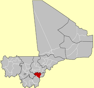 Location of the Cercle of Koutiala in Mali | |
| Country |
|
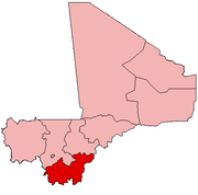
| Region | Sikasso Region |
| Cercle | Koutiala |
| Admin HQ (Chef-lieu) | Koutiala |
| Area[1] | |
| • Total | 8,740 km2 (3,370 sq mi) |
| Population (2009 census) | |
| • Total | 575,253 |
| • Density | 66/km2 (170/sq mi) |
| Time zone | GMT (UTC+0) |
Koutiala Cercle is an administrative subdivision of the Sikasso Region of southern Mali. The administrative center is the town of Koutiala. The Cercle is divided into 36 communes.
Economy
Koutiala is the heartland of the cotton production in Mali and its main town is sometimes called "the white gold capital" for its cotton.[2] However, the industry has been affected by stagnation since the 1980s.[3] Aside from cotton it is also noted for grain production, primarily pearl millet, sorghum and maize.[4]
Administrative divisions
The Cercle of Koutiala is divided into 36 communes:[5][6]
References
- ↑ Synthèsis des Plans de Securité Alimentaire des Communes du Cercle Koutiala 2007-2011 (PDF) (in French), Commissariat à la Sécurité Alimentaire, République du Mali, USAID-Mali, 2007.
- ↑ López-Ridaura, Santiago (2005). Multi-scale sustainability evaluation: a framework for the derivation and quantification of indicators for natural resource management systems. Wageningen University and Research Centre. ISBN 978-90-6754-954-7. Retrieved 5 January 2011.
- ↑ Benjaminsen, Tor Arve; Lund, Christian (2001). Politics, property and production in the West African Sahel: understanding natural resources management. Nordic Africa Institute. p. 263. ISBN 978-91-7106-476-9. Retrieved 5 January 2011.
- ↑ Morrisson, Christian; Lecaillon, Jacques. Economic Policies and Agricultural Performance. OECD. p. 161. Retrieved 5 January 2011.
- ↑ Loi N°99-035/ du 10 Aout 1999 Portant Création des Collectivités Territoriales de Cercles et de Régions (PDF) (in French), Ministère de l'Administration Territoriales et des Collectivités Locales, République du Mali, 1999.
- ↑ Communes de la Région de Sikasso (PDF) (in French), Ministère de l’administration territoriale et des collectivités locales, République du Mali.
| Kayes Region |  | |
|---|---|---|
| Koulikoro Region | ||
| Sikasso Region | ||
| Ségou Region | ||
| Mopti Region | ||
| Tombouctou Region | ||
| Gao Region | ||
| Kidal Region | ||
| Bamako Capital District | ||
Coordinates: 12°20′N 5°35′W / 12.333°N 5.583°W
This article is issued from Wikipedia - version of the 10/3/2016. The text is available under the Creative Commons Attribution/Share Alike but additional terms may apply for the media files.