Zégoua
| Zégoua | |
|---|---|
| Commune and town | |
 Zégoua Location in Mali | |
| Coordinates: 10°29′15″N 5°39′13″W / 10.48750°N 5.65361°WCoordinates: 10°29′15″N 5°39′13″W / 10.48750°N 5.65361°W | |
| Country |
|
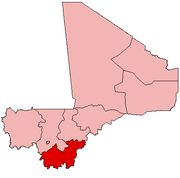
| Region | Sikasso Region |
| Cercle | Kadiolo Cercle |
| Area[1] | |
| • Total | 490 km2 (190 sq mi) |
| Population (1998)[2] | |
| • Total | 30,636 |
| • Density | 63/km2 (160/sq mi) |
| Time zone | GMT (UTC+0) |
Zégoua is a small town and rural commune in the Cercle of Kadiolo in the Sikasso Region of southern Mali. The commune covers an area of 490 square kilometers and includes the town and 8 villages.[3] In the 2009 census it had a population of 30,636.[2] The town of Zégoua, the administrative center (chef-lieu) of the commune, is 2 km north of the border with the Ivory Coast and 14 km southeast of Kadiolo on the RN7, the main road linking Sikasso and Ouangolodougou.
References
- ↑ "Common and Fundamental Operational Datasets Registry: Mali", United Nations Office for the Coordination of Humanitarian Affairs http://cod.humanitarianresponse.info/country-region/mali Missing or empty
|title=(help). commune_mali.zip (Originally from the Direction Nationale des Collectivités Territoriales, République du Mali) - 1 2 Resultats Provisoires RGPH 2009 (Région de Sikasso) (PDF) (in French), République de Mali: Institut National de la Statistique.
- ↑ Communes de la Région de Sikasso (PDF) (in French), Ministère de l’administration territoriale et des collectivités locales, République du Mali.
External links
- Plan de Sécurité Alimentaire Commune Rurale de Zégoua 2006-2010 (PDF) (in French), Commissariat à la Sécurité Alimentaire, République du Mali, USAID-Mali, 2006.
This article is issued from Wikipedia - version of the 3/8/2013. The text is available under the Creative Commons Attribution/Share Alike but additional terms may apply for the media files.