South Fourche LaFave River Bridge
|
South Fourche LaFave River Bridge | |
 | |
  | |
| Nearest city | Hollis, Arkansas |
|---|---|
| Coordinates | 34°52′22″N 93°6′38″W / 34.87278°N 93.11056°WCoordinates: 34°52′22″N 93°6′38″W / 34.87278°N 93.11056°W |
| Area | less than one acre |
| Built | 1933 |
| Architectural style | Parker pony-truss |
| MPS | Historic Bridges of Arkansas MPS |
| NRHP Reference # | 04001044[1] |
| Added to NRHP | September 24, 2004 |
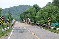
The South Fourche LaFave River Bridge is a historic bridge in rural western Perry County, Arkansas. It is a two-span Parker pony truss bridge, carrying Arkansas Highway 7 across the river, roughly midway between Ola and Jessieville in the eastern reaches of Ouachita National Forest. The bridge was built in 1933, and has a total length of 485 feet (148 m), each of its main spans measuring 102 feet (31 m).[2]
The bridge was listed on the National Register of Historic Places in 2004.[1]
See also
- National Register of Historic Places listings in Perry County, Arkansas
- List of bridges on the National Register of Historic Places in Arkansas
References
- 1 2 National Park Service (2010-07-09). "National Register Information System". National Register of Historic Places. National Park Service.
- ↑ "NRHP nomination for South Fourche LaFave River Bridge" (PDF). Arkansas Preservation. Retrieved 2016-04-01.
| Topics | |
|---|---|
| Lists by states |
|
| Lists by insular areas | |
| Lists by associated states | |
| Other areas | |
| |
This article is issued from Wikipedia - version of the 12/2/2016. The text is available under the Creative Commons Attribution/Share Alike but additional terms may apply for the media files.