South Street, Bromley

Coordinates: 51°17′51″N 0°03′06″E / 51.297564°N 0.051799°E
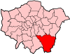
South Street is a hamlet located in the far south of the London Borough of Bromley,[1] 16.5 miles (27 km) south south-east from Charing Cross. It is the highest settlement in all of London, located about 220 metres (722 ft) above sea level. The hamlet is located about 6 miles (9.7 km) from Junction 5 of the M25.
Since the early 1920s, the area has more generally been known as Westerham Hill, the name South Street having fallen out of favour for being overly generic.[2]
Like neighbouring villages, South Street’s principal crop was strawberries, grown on a dozen farms and sold at Covent Garden. South Street also staged an annual horse show and had a stud farm.[2]
References
This article is issued from Wikipedia - version of the 9/15/2016. The text is available under the Creative Commons Attribution/Share Alike but additional terms may apply for the media files.