Bountiful, Utah
| Bountiful, Utah | |
|---|---|
| City | |
|
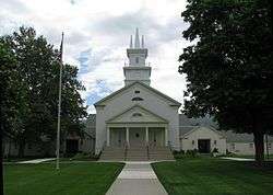
The Bountiful Utah Tabernacle of The Church of Jesus Christ of Latter-day Saints | |
 Location in Davis County and the state of Utah. | |
| Coordinates: 40°52′47″N 111°52′18″W / 40.87972°N 111.87167°WCoordinates: 40°52′47″N 111°52′18″W / 40.87972°N 111.87167°W | |
| Country | United States |
| State | Utah |
| County | Davis |
| Settled | September 27, 1847 |
| Incorporated | 1892 |
| Founded by | Perrigrine Sessions |
| Named for | Bountiful (Book of Mormon) |
| Government | |
| • Mayor | Randy Lewis |
| Area | |
| • Total | 13.5 sq mi (34.9 km2) |
| • Land | 13.5 sq mi (34.9 km2) |
| • Water | 0.0 sq mi (0.0 km2) |
| Elevation[1] | 4,797 ft (1,462 m) |
| Population (2012) | |
| • Total | 42,898 |
| • Density | 3,152/sq mi (1,219.3/km2) |
| Time zone | MST (UTC-7) |
| • Summer (DST) | MDT (UTC-6) |
| ZIP code | 84010 - 84011 |
| Area code(s) | 385, 801 |
| FIPS code | 49-07690[2] |
| GNIS feature ID | 2409885[1] |
| Website | http://bountifulutah.gov |
Bountiful is a city in Davis County, Utah, United States. As of the 2010 census, the city population was 42,552, a three percent increase over the 2000 figure of 41,301. The city grew rapidly during the suburb growth of the late 1940s, 1950s, and 1960s and was Davis County's largest city until 1985 when it was surpassed by Layton. Bountiful is currently Utah's 15th largest city.
Although a part of the Ogden-Clearfield Metropolitan Statistical Area, it serves as a bedroom community to Salt Lake City and the surrounding area. However, due to the very narrow entrance into Salt Lake County, roads between the counties often reach near-gridlock traffic during rush hour. The FrontRunner commuter rail has been running since April 2008, and the Legacy Parkway was opened on September 13, 2008. These were built to help alleviate the traffic load on Interstate 15 through the Bountiful area.
History
Bountiful was settled on September 27, 1847, by Perrigrine Sessions and his family. It was Utah's second settlement after Salt Lake City. It was known as both Sessions Settlement and North Canyon Ward before being named Bountiful in 1855. This city was so named both because of the city's reputation as a garden place and because "Bountiful" is the name of a city in the Book of Mormon (Alma 52:9).[3] Most of the settlers, and also most of the present inhabitants, are members of The Church of Jesus Christ of Latter-day Saints (LDS). The Bountiful Utah Temple was dedicated in 1995 by the LDS Church. A tabernacle of The Church of Jesus Christ of Latter-day Saints is also located in Bountiful.
The city was incorporated in 1892 with Joseph L Holbrook as mayor.
In 1907 electric lights came to Bountiful through the efforts of its citizens.[4]
Notorious serial killer Ted Bundy snatched victim Debra Kent from Viewmont High School in Bountiful on November 8, 1974.
The city maintains a charming Main Street, with several locally owned shops, and is home to several big-box retailers.
The city celebrates its history at the annual Handcart Days celebration every July in conjunction with U.S. State of Utah’s official holiday, Pioneer Day. Bountiful Handcart Days is a volunteer–driven event. People from three cities in the south of Davis County, Utah come together to commemorate the first group of Mormon Pioneers’ entry into the Salt Lake Valley on July 24, 1847. The festivities include a parade, fireworks, games, entertainment, an art exhibit, and food.
Geography
According to the United States Census Bureau, the city has a total area of 13.5 square miles (34.9 km²), all of it land.
The original portion of the city and downtown are located at the base of the Wasatch Range, which rises high to the east, overlooking the city. Most of the residential neighborhoods climb high up the slopes of the mountain. To the west lies a flatland that extends to the Great Salt Lake and the mudflats and marshes that border it. Areas of Bountiful include Val Verda in the southern part of the city.[5]
The cities surrounding Bountiful include: North Salt Lake to the south, Woods Cross and West Bountiful to the west, and Centerville to the north. Most land to the east of Bountiful is U.S. Forest Service property.
Climate
This climatic region is typified by large seasonal temperature differences, with warm to hot (and often humid) summers and cold (sometimes severely cold) winters. According to the Köppen Climate Classification system, Bountiful has a humid continental climate, abbreviated "Dfb" on climate maps.[6]
Demographics
| Historical population | |||
|---|---|---|---|
| Census | Pop. | %± | |
| 1860 | 868 | — | |
| 1870 | 1,517 | 74.8% | |
| 1880 | 1,676 | 10.5% | |
| 1890 | 2,438 | 45.5% | |
| 1900 | 1,442 | −40.9% | |
| 1910 | 1,677 | 16.3% | |
| 1920 | 2,003 | 19.4% | |
| 1930 | 2,571 | 28.4% | |
| 1940 | 3,357 | 30.6% | |
| 1950 | 6,004 | 78.9% | |
| 1960 | 17,039 | 183.8% | |
| 1970 | 27,751 | 62.9% | |
| 1980 | 32,877 | 18.5% | |
| 1990 | 36,659 | 11.5% | |
| 2000 | 41,301 | 12.7% | |
| 2010 | 42,552 | 3.0% | |
| Est. 2015 | 43,784 | [7] | 2.9% |
As of the census[2] of 2000, there was 13,341 households, and 10,766 families residing in the city. The population density was 3,065.3 people per square mile (1,183.8/km²). There were 13,819 housing units at an average density of 1,025.6 per square mile (396.1/km²). The racial makeup of the city was 95.56% White, 0.24% African American, 0.27% Native American, 1.15% Asian, 0.32% Pacific Islander, 1.12% from other races, and 1.34% from two or more races. Hispanic or Latino of any race were 2.90% of the population.
There were 13,341 households out of which 38.1% had children under the age of 18 living with them, 69.3% were married couples living together, 8.9% had a female householder with no husband present, and 19.3% were non-families. 16.7% of all households were made up of individuals and 7.6% had someone living alone who was 65 years of age or older. The average household size was 3.05 and the average family size was 3.46.
In the city the population was spread out with 29.7% under the age of 18, 11.6% from 18 to 24, 23.9% from 25 to 44, 20.5% from 45 to 64, and 14.3% who were 65 years of age or older. The median age was 32 years. For every 100 females there were 94.4 males. For every 100 females age 18 and over, there were 91.1 males.
The median income for a household in the city was $55,993, and the median income for a family was $62,905. Males had a median income of $45,420 versus $27,354 for females. The per capita income for the city was $23,967. About 3.0% of families and 4.0% of the population were below the poverty line, including 5.1% of those under age 18 and 4.2% of those age 65 or over.
Medical facilities
Lakeview Hospital is a hospital located in Bountiful.
Public schools
Elementary Schools[9]
- Adelaide Elementary
- Boulton Elementary
- Bountiful Elementary
- Holbrook Elementary
- Meadowbrook Elementary
- Muir Elementary
- Oak Hills Elementary
- Tolman Elementary
- Valley View Elementary
- Washington Elementary
Junior High Schools[9]
- Bountiful Junior High School
- Millcreek Junior High School
- Mueller Park Junior High School
- South Davis Junior High School
High Schools
- Bountiful High School
- Viewmont High School
- Woods Cross High School
Sights of interest
- Bountiful Utah Temple of The Church of Jesus Christ of Latter-day Saints, dedicated 1995
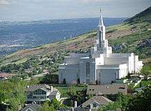 The Bountiful Utah Temple of The Church of Jesus Christ of Latter-day Saints
 - Bountiful Utah Tabernacle of The Church of Jesus Christ of Latter-day Saints, erected 1862
- Mueller Park trails[10]
Notable people
- Bryan H. Carroll, director, producer, screenwriter and editor
- Keene Curtis, stage, film and television actor
- Henry B. Eyring, First Counselor in the First Presidency of The Church of Jesus Christ of Latter-day Saints
- Parker Jacobs, actor, artist and performer
- Chris Jones, software developer, and star of the Tex Murphy PC series
- James Morrison (actor)
- George Ouzounian, a.k.a. Maddox (writer)
- Ivy Baker Priest, the United States Treasurer under President Eisenhower; mother of Pat Priest[11]
- Pat Priest, actress (The Munsters) lived in Bountiful until her junior year of high school[11]
- Jon Schmidt, new-age pianist and composer
- Norman D. Shumway, a former United States congressman
See also
References
- 1 2 U.S. Geological Survey Geographic Names Information System: Bountiful
- 1 2 "American FactFinder". United States Census Bureau. Archived from the original on 2013-09-11. Retrieved 2008-01-31.
- ↑ Van Atta, Dale (Jan 22, 1977). "You name it - there's a town for it". The Deseret News. p. 15. Retrieved 18 October 2015.
- ↑ http://www.bountifulutah.gov/BountifulHistory.aspx
- ↑ Edwards, Alan (May 29, 1996). "Val Verda Still Goes Its Own Way". Deseret News. Retrieved April 2, 2012.
- ↑ Climate Summary for Bountiful, Utah
- ↑ "Annual Estimates of the Resident Population for Incorporated Places: April 1, 2010 to July 1, 2015". Retrieved July 2, 2016.
- ↑ "Census of Population and Housing". Census.gov. Archived from the original on May 11, 2015. Retrieved June 4, 2015.
- 1 2
- ↑ Argyle, Bruce. "Website Editor". Retrieved 1 January 2014.
- 1 2 Pat Priest Interview by Joe Krein at Elvis2001.net
External links
![]() Media related to Bountiful, Utah at Wikimedia Commons
Media related to Bountiful, Utah at Wikimedia Commons
 |
West Bountiful | Centerville | Morgan | |
| Woods Cross | |
East Canyon State Park / Coalville | ||
| ||||
| | ||||
| North Salt Lake | Salt Lake City |
Municipalities and communities of Davis County, Utah, United States | ||
|---|---|---|
| Cities | 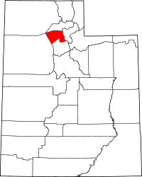 | |