Srbac
| Srbac Србац | ||
|---|---|---|
| BG | ||
 | ||
| ||
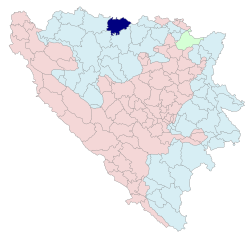 Location of Srbac within Republika Srpska | ||
| Coordinates: 45°06′N 17°31′E / 45.100°N 17.517°E | ||
| Country |
| |
| Entity |
| |
| Government | ||
| • Mayor | Drago Ćirić | |
| Area | ||
| • Total | 452,51 km2 (17,472 sq mi) | |
| Population (2013 census) | ||
| • Total | 19,001 | |
| Time zone | CET (UTC+1) | |
| • Summer (DST) | CEST (UTC+1) | |
| Area code(s) | 51 | |
| Phone code | +387 | |
| Website | www.srbac-rs.com | |

Srbac (Serbian Cyrillic: Србац), is a town and municipality on the northern border of Bosnia and Herzegovina with Croatia. Srbac is located in the Republika Srpska entity at the entry of river Vrbas into river Sava.
Geography and climate
Geography

Srbac covers some 453 km² (174.9 mi²) of land in northern Bosnia situated at the entry of the river Vrbas into river Sava. The municipality consists of 39 villages. The city is located at 45.06° N 17.31° E.
The source of the river Vrbas is about 140 km (87 mi) to the south, and the tributary rivers of Suturlija, Crkvena, and Vrbanja flow into the Vrbas at the city of Banja Luka.
The area around Srbac is mountainous woodland to the south-east (40% of the total area) and farmland to the south-west (60% of total area). The city itself is built in the Pannonia valley, which is located on the transition between low mountain areas and flat farmlands. The mountain ranges to the south-east are called Motajica and the highest peak is called Gradina at 652m above sea level. The lowest point is 89m in the Vlaknica (small village) farmlands along the Sava river. The northern border of the municipality with the Republic of Croatia is 42 km long.
Srbac is about 200 km away from the Bosnian capital Sarajevo, 400 km away from the Serbian capital Belgrade, and 250 km away from the Croatian capital Zagreb.
Climate
Srbac has a continental climate, with harsh winters and warm summers. The warmest month of the year is July, with an average temperature of 25°C (77°F). The coldest month of the year is January, when temperatures average -5°C (23 °F). Annual precipitation for Srbac is about 875 mm. Due to the city's high latitude; it snows in Srbac almost every year as well. Strong winds come from the north and northeast bringing in lots of snow.
History


Archaeological evidence points to an Iron Age settlement existing in the region (Cagan grad). Before the collapse of the Western Roman Empire a town was mentioned in this area. As throughout in the Balkans during Ottoman occupation, towns were constantly burnt and destroyed. In the cadastral area of modern Srbac the historical town of Svinjar existed (meaning "swine stable").
At the time of the Long War (1591–1606), Ahmet Hafiz-pasha transported his huge army from Ottoman-held Slavonia across the Sava at Svinjar further into Bosnia (1596). During Ottoman occupation the region was part of the Sanjak of Bosnia. Svinjar was one of the important rebel sites in Bosnia during the Herzegovina Uprising (1875–78) against the Ottoman Empire; one of the battles took place here on 21 November 1875 at a place called Srbac where hajduks of Motajica burnt down and destroyed an Ottoman military camp.
In the late 19th century Svinjar was under Austro-Hungary. In 1888 a primary school was opened in Svinjar. Between the years of 1899 to 1921 around 7,000 Poles and around 5,000 Ukrainians migrated and settled in the area. Towards the end of 1929 a medical centre was also opened in Svinjar. On 2 November 1933 the minister of internal affairs of the Kingdom of Yugoslavia changed the town name into Srbac.
During World War II these parts were frequently invaded by all the waring sides. During the 1970s Srbac saw rapid growth with the opening of a new textile factory and a packaging material factory. However, economic growth stopped during the Bosnian War. Srbac was bombarded 3 times during the war by Croatian forces in the summer of 1992 only. No one was killed in these 3 incidents and Srbac suffered only minor structural damage.
Demographics

1971
21,840 total.[1]
- 19,382 Serbs (88.75%)
- 940 Bosniaks (4.30%)
- 140 Croats (0.64%)
- 811 Yugoslavs (3.71%)
- 567 others (2.60%)
1991
In 1991, the population of the Srbac municipality numbered 21,660 inhabitants, including:
- 19,291 Serbs (89.06%)
- 940 Bosniaks (4.34%)
- 754 Yugoslavs (3.48%)
- 145 Croats (0.70%)
- 530 others (2.4%)
See also
References
External links
Coordinates: 45°06′N 17°31′E / 45.100°N 17.517°E
| Wikimedia Commons has media related to Srbac. |