Livno
| Livno Ливно | |||
|---|---|---|---|
| Town and municipality | |||
 | |||
| |||
 Map of the Town of Livno
| |||
 Livno Location of Livno in BiH | |||
| Coordinates: 43°49′31″N 17°00′21″E / 43.82528°N 17.00583°ECoordinates: 43°49′31″N 17°00′21″E / 43.82528°N 17.00583°E | |||
| Country | Bosnia and Herzegovina | ||
| Canton | Canton 10 | ||
| First mentioning | 28 September 892 CE | ||
| Government | |||
| • Mayor | Luka Čelan (HDZ BiH) | ||
| Area | |||
| • Municipality | 994 km2 (384 sq mi) | ||
| Elevation | 724 m (2,375 ft) | ||
| Population (2013) | |||
| • Total | 37,487 | ||
| • Density | 38/km2 (100/sq mi) | ||
| • Town | 9,045 | ||
| Time zone | CET (UTC+1) | ||
| • Summer (DST) | CEST (UTC+2) | ||
| Postal code | 80101 | ||
| Area code | 34 | ||
| Website |
livno | ||

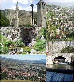
Livno (Serbo-Croatian pronunciation: [lǐːʋno]) is a town and municipality in the west of Bosnia and Herzegovina. It is part of Canton 10 of the Federation of Bosnia and Herzegovina. Situated on the river Bistrica in the southeastern edge of the Livno Field at the foot of Krug mountain and rocky hill Crvenice, it is the centre of the Canton 10 which mainly covers an area of the historical and geographical region of Tropolje.[1][2]
The town, with the remains of the antique architecture and the old town from the 9th century, first mentioned in 892, developed at the crossroads of roads between the Adriatic coast and inland, i.e, regions of Bosnia, Dalmatia, Herzegovina and Krajina.[3]
History
The plains of Livno have been populated since approximately 2000 BC. In the late Bronze Age, the Neolithic population was replaced by more Indo-European tribes known as the Illyrians. The region was inhabited by Illyrian tribe of Dalmatae which capital was Delminium in today's Tomislavgrad. They left remains that testify about their presence in this area. The most important of them are the gradine, remains of Illyrian settlements which were distributed along the Livno Field. The three most important are Velika gradina, Mala gradina and Kasalov gradac.[4]
After the Roman conquest of the area, it was part of the province of Dalmatia. During the twenties of the first century AD, Roman government built a road connecting Salona, a city on the coast with Servitium, a city at the peripanonic lowlands. Its route passed through the Livno Field where two road stations have been established. The station of Pelva was located at the area of village Lištani and in the area of Livno station Bariduo was based.[5]
Livno celebrates its founding date as 28 September 892 AD, being mentioned in a document from Duke Mutimir which was released at that time. It was the centre of Hlebiana (ή Χλεβίανα) županija (province) of the Kingdom of Croatia, as mentioned in the tenth century work De Administrando Imperio (chapter 30). From 1199 Emeric until 1326 Mladen II Šubić of Bribir, who was a resident of Livno, it was part of the Chelmensis territory. From 1326 until 1463 Livno was part of the Bosnian Kingdom. One of the noble families of the Bosnian Kingdom bought Livno, Duvno, and Kupres (12th to 13th century) then called "Tropolje," (Three Fields).
The beginning of 15th century saw the Ottoman Empire advance, invade, and occupy Bosnia for the next 400 years. Mosque complex in the picture (left) the Hajji Ahmed the Ducat Minter's Mosque (more commonly known as the Glavica ("Head") Mosque, called after the knap above town on which it is erected) is one of the most recognizable architectural symbols of Livno. Constructed upon design by Mimar Sinan in 1574. (some date to 1587), it is situated on a hill overlooking the old town of Livno, the river Bistrica and the spring Duman in the upper section of the old town of Livno. The mosque complex consists of compact main building of the mosque under a dome and uncharacteristically short minaret, with a clock tower which was erected around 1659, and is still in use today. Within the perimeter is an almost 500-year-old necropolis with characteristic early Bosnian Muslim tombstones and later ones.[6][7]
In 1878 Livno was occupied by the Austro-Hungarian Empire. From 1918 it was part of the Kingdom of Serbs, Croats and Slovenes. In 1929 the kingdom was renamed the Kingdom of Yugoslavia and divided into nine banates (banovine). Livno was divided into the Littoral Banovina, with its centre in the city of Split. This division brought Livno politically closer to Croatia. In 1939, the banates were further redrawn so that there was a Croatian banate (Banovina Hrvatska) of which Livno was also part.
From 1941-45, Livno was part of the Independent State of Croatia. Croatian writer Ivan Goran Kovačić joined the Partisans where he wrote his epic poem "Jama" ("The Pit"). He finished his poem in Livno. At the end of World War II, Livno was a part of Socialist Republic of Bosnia and Herzegovina, Yugoslavia, and after its collapse in 1995, a part of Bosnia and Herzegovina.
Position
Livno is 96 km[8] from Split, 127 km [9] from Mostar, 167 km[10] from Banja Luka and 212 km [11] from Sarajevo.
Demographics
| 1879 | 1,425 | 31 | 2,394 | 52 | 778 | 17 | 0 | 0 | 4,597 | 1879 Glavni pregled političkoga razdielenja Bosne i Hercegovine | |
| 1948 | |
|
|
|
| ||||||
| 1953 | |
|
|
|
| ||||||
| 1961 | |
|
|
|
| ||||||
| 1971 | |
|
|
|
| ||||||
| 1981 | |
|
|
|
| ||||||
| 1991 | |
|
|
|
| ||||||
| 2013 | |
|
|
|
| ||||||
Settlements
• Bila • Bilo Polje • Bogdaše • Bojmunte • Čaić • Čaprazlije • Čelebić • Čuklić • Ćosanlije • Dobro • Donji Rujani • Drinova Međa • Držanlije • Golinjevo • Gornji Rujani • Grborezi • Grgurići • Gubin • Komorani • Kovačić • Lipa • Lištani • Livno • Lopatice • Lusnić • Ljubunčić • Mali Guber • Mali Kablići • Miši • Odžak • Orguz • Podgradina • Podgreda • Podhum • Potkraj • Potočani • Potok • Priluka • Prisap • Prolog • Provo • Radanovci • Rapovine • Sajković • Smričani • Srđevići • Strupnić • Suhača • Tribić • Veliki Guber • Veliki Kablići • Vidoši • Vrbica • Vržerala • Zabrišće • Zagoričani • Zastinje • Žabljak • Žirović
Geography
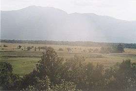
The territory of the municipality is 994 km2 (384 sq mi). Livno is both the cultural and industrial center of the canton. It is the biggest city in the canton and situated 730 meters above sea level. The Bistrica river flows through the city and is itself is 3 km (1.9 mi) long, which means that it is a very small river. Livno is also situated in the Livanjsko field which is the largest field in the entire country. The field is situated between the mountains Dinara and Kamešnica in the south, Tušnica in the east, Cincar in the north and Šator in the west. Livanjsko field is 405 km2 (156 sq mi), making it almost half of the Livno municipality.
Climate
Livno has a stable continental climate with cold winters and hot summers. It is situated between mountains like Cincar and Kamesnica which make the climate more continental than the climate in Mostar and Čapljina for example. The winters in that part of the country are not as cold as in Livno. Climate in this area has mild differences between highs and lows, and there is adequate rainfall year round. The Köppen Climate Classification subtype for this climate is "Cfb" (Marine West Coast Climate/Oceanic climate).[19]
Governance
The main local government of the municipality is Municipal Council of Livno (Bosnian: Općinska skupština; Croatian: Općinsko vijeće; Serbian Latin: Opštinska skupština). Council has 31 members elected for a four-year term by proportional representation. Livno has its municipal mayor who is the highest-ranking officer in the municipal government.
Structure of the Council
| party | 1997 | 2000 | 2004 | 2008 | 2012 | |
|---|---|---|---|---|---|---|
| Croatian Democratic Union (HDZ) | 20 | 20 | 16 | 8 | 11 | |
| Croatian Democratic Union 1990 (HDZ 1990) | - | - | - | 5 | 6 | |
| People's Party for Work and Betterment (NSRZB) | - | - | 3 | 12 | 4 | |
| Croatian Party of Rights (HSP) | - | - | 1 | 1 | 3 | |
| Party of Democratic Action (SDA) | 5 | 3 | 5 | 3 | 3 | |
| Social Democratic Party (SDP) | 1 | 3 | 2 | 1 | 2 | |
| Croatian Peasant Party of Stjepan Radić (HSS SR) | - | - | - | - | 1 | |
| Independent | 2 | - | - | - | 1 | |
Sport
Livno is a sports city and has many sport clubs, the most famous of which is Troglav 1918. Futsal is represented with MNK Seljak.
Transport
M16 road, passing through Kupres and Šujica, connects Livno with Croatia and Central Bosnia. M6.1 starts at Bosansko Grahovo, runs through Livno connecting it with Tomislavgrad, Herzegovina and Mostar. Going northwards M15 connects Livno with Glamoč and northern Bosnia and Herzegovina.
Notable people
- Hasan Brkić (1913–1965), politician
- Niko Čeko, former Croatia national football team player
- Zlatko Dalić, former football player, coach
- Gabrijel Jurkić (1886-1974), painter
- Niko Kovač, former Croatia national football team player, captain and coach
- Robert Kovač, former Croatia national football team player
- Borjana Krišto, politician, former president of the Federation of Bosnia and Herzegovina
- Filip Mihaljević, shot put and discus thrower, 2016 Summer Olympics competitor, multiple youth European championships medalist (for Croatia)
- Vukašin Mrnjavčević (c. 1320-1371), Serbian medieval ruler
- Mate Rimac, entrepreneur, CEO of Rimac Automobili
- Mladen II Šubić of Bribir (c. 1270-c. 1341), Croatian leader and member of the Šubić family
- Davor Šuker, former Croatia national football team player, captain, all-time leading goalscorer, 1998 FIFA World Cup top scorer, Croatian Football Federation president
- Almir Velagić, weightlifter, 2008 and 2012 Summer Olympics competitor, multiple European championships medalist (for Germany)
References
Notes
- ↑ "Livno". enciklopedija.hr. Miroslav Krleža Institute of Lexicography. Retrieved 8 June 2016.
- ↑ "Stari grad u Livnu (Bistrički grad), historijsko područje". Bosnia and Herzegovina Commission to Preserve National Monuments. Retrieved 8 June 2016.
- ↑ "Livno". proleksis.lzmk.hr. Miroslav Krleža Institute of Lexicography. Retrieved 8 June 2016.
- ↑ "Povijest Livna". livno.ba. Municipality of Livno. Retrieved 29 December 2015.
- ↑ Bojanovski, Ivo (1974). Dolabelin sistem cesta u rimskoj provinciji Dalmaciji. Sarajevo: Akademija nauka i umjetnosti Bosne i Hercegovine. p. 59.
- ↑ Medzlis (27 December 2010). "Džemat Glavica – Milošnik". medzlis-livno.com. Retrieved 4 March 2013.
- ↑ Sir H. A. R. Gibb; J H Kramers (1954). The Encyclopaedia of Islam. Leiden: E.J. Brill. Retrieved 4 March 2013.
- ↑ Michelin Livno-Split
- ↑ Michelin Livno Mostar
- ↑ Michelin Livno-Banja Luka
- ↑ Michelin Livno-Sarajevo
- ↑ 1948 census.
- ↑ 1953 census.
- ↑ 1961 census.
- ↑ 1971 census.
- ↑ 1981 census.
- ↑ 1991 census.
- ↑ 2013 census.
- ↑ Climate Summary for Livno
Books
- Konačni rezultati popisa stanovništva od 15. marta 1948. godine (in Serbo-Croatian). 9. Belgrade: Savezni zavod za statistiku i evidenciju. 1955.
- Nacionalni sastav stanovništva SFR Jugoslavije: podaci po naseljima i opštinama (in Serbo-Croatian). 1. Belgrade: Federal Statistical Office. 1991.
- Nacionalni sastav stanovništva SFR Jugoslavije: podaci po naseljima i opštinama (in Serbo-Croatian). 2. Belgrade: Federal Statistical Office. 1994.
- Nacionalni sastav stanovništva SFR Jugoslavije: podaci po naseljima i opštinama (in Serbo-Croatian). 3. Belgrade: Federal Statistical Office. 1994.
- Nacionalni sastav stanovništva: rezultati za Republiku po opštinama i naseljenim mjestima 1991. (in Serbo-Croatian). Sarajevo: State Bureau for Statistics of the Republic of Bosnia and Herzegovina. 1994.
- Popis stanovništva 1953. (in Serbo-Croatian). 11. Belgrade: Federal Statistical Office. 1960.
External links
| Wikimedia Commons has media related to Livno. |
- Municipality of Livno website (Croatian)
- Livno Online (Croatian)
- Aero Club of Livno (Croatian)
- Tourism Association of Bosnia-Herzegovina site about Livno