Bileća
| Bileća Билећа | |||
|---|---|---|---|
| Town | |||
|
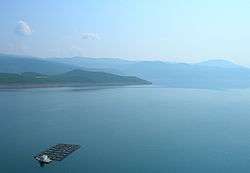
Lake Bileća | |||
| |||
 Location of Bileća within Bosnia and Herzegovina | |||
| Country | Bosnia and Herzegovina | ||
| Entity | Republika Srpska | ||
| Settlements | 61 (2013.) | ||
| Government | |||
| • Mayor | Miljan Aleksić (SNSD) | ||
| Area | |||
| • Total | 632,33 km2 (24,414 sq mi) | ||
| Population (2013 census) | |||
| • Total | 11,536 | ||
| Time zone | CET (UTC+1) | ||
| • Summer (DST) | CEST (UTC+2) | ||
| Area code(s) | 59 | ||
| Website |
opstinabileca | ||


Bileća (Serbian Cyrillic: Билећа) is a town and municipality in Bosnia and Herzegovina and a part of the Republika Srpska entity. It is located in East Herzegovina, near the border with Montenegro, north of Trebinje and south of Gacko.
Settlements
Baljci • Bijela Rudina • Bijeljani • Bileća • Bodenik • Bogdašići • Brestice • Čepelica • Deleuša • Divin • Dlakoše • Dola • Donja Meka Gruda • Donji Davidovići • Đeče • Fatnica • Golobrđe • Gornja Meka Gruda • Gornji Davidovići • Granica • Hodžići • Kačanj • Kalac • Korita • Krivača • Krstače • Kukričje • Kuti • Lađevići • Milavići • Mirilovići • Miruše • Mrežica • Narat • Njeganovići • Oblo Brdo • Orah • Orahovice • Pađeni • Panik • Plana • Podgorje • Podosoje • Preraca • Prijevor • Prisoje • Rioca • Selišta • Simijova • Skrobotno • Šobadine • Todorići • Torić • Trnovica • Vlahinja • Vranjska • Vrbica • Zasada • Zaušje • Zvijerina • Žudojevići
History
The first traces of civilization in Bileća date from the Neolithic period, although archaeological sites are insufficiently explored. The first written documentation of Bileća as an inhabited place can be found in Ragusan documents dating from 1286, when it is mentioned under the name Bilechia. Bileća is mentioned in the 14th and 15th century as an important cross road town in caravan routes. A document dated 8 September 1388, mentions that the army of duke Vlatko Vuković defeated the Turkish army at the Battle of Bileća. In the period from 13th to 16th century in the history of this area is a large number of the "stećci" monolith markers which weigh up to 5 tons. Bileća was held by the Turks from 1466, although this was a rebellious area difficult to control. Nearby lies the town of Vučji Do, in which the Battle of Vučji Do took place in 1876. The Berlin's Congress included Bileća in the Austro-Hungarian Empire, which brought economic development to the region. The first primary school in Bileća was opened in 1880.
Demographics
According to the 1910 census, the absolute majority in the Bileća municipality were Orthodox Christians (82.27%). According to the Kingdom of Yugoslavia 1931 population census, the majority was held by Orthodox Christians 81.27%.
| year of census | total | Serbs | Muslims | Croats | Yugoslavs | others |
|---|---|---|---|---|---|---|
| 1971 | 13,444 | 10,880 (80.92%) | 2,079 (15.46%) | 82 (0.60%) | 69 (0.51%) | 334 (2.51%) |
| 1981 | 13,199 | 10,190 (77.20%) | 1,803 (13.66%) | 44 (0.33%) | 727 (5.50%) | 435 (3.29%) |
| 1991 | 13,284 | 10,628 (80.00%) | 1,947 (14.65%) | 39 (0.29%) | 222 (1.67%) | 448 (3.37%) |
Features
- The Diocese of Zahumlje-Herzegovina and Littoral (official site in Serbian), Serbian Orthodox Church (official site in English)
- Hydroelectric power plants on the Trebisnjica River (near Bileća)
- Lake Bileća (Bilećko jezero) is located south of the town.
People
- Safet Isović, singer
- Beba Selimović, singer
- Fadil Hadžić, movie director and writer
- Dušan Vukotić, Oscar for best animated short in 1961 for Surogat
- Jevto Dedijer, writer
- Nenad Mišanović, basketball player
- Prokopije Čokorilo, priest
- Ervin Eleskovic, Swedish tennis player
- Tijana Bošković, Serbian volleyball player, silver medalist at the 2016 Summer Olympics
- Momo Kapor, writer
- Karl Malden, actor
See also
- Municipalities of Republika Srpska
- Bileca official site - www.opstinabileca.ba
- BILECA info site
- Portal Site www.bileca.org
Coordinates: 42°52′N 18°26′E / 42.867°N 18.433°E
| Wikimedia Commons has media related to Bileća. |