Tuzla Canton
| Tuzlanski kanton[1](bs) Tuzlanska županija (hr) Тузлански кантон (sr) | |||
|---|---|---|---|
| Canton | |||
| |||
 Location of the Tuzla Canton | |||
| Coordinates: 44°33′N 18°36′E / 44.550°N 18.600°E | |||
| Country | Bosnia and Herzegovina | ||
| Entity | Federation of Bosnia and Herzegovina | ||
| Main city | Tuzla | ||
| Municipalities | |||
| Government | |||
| • Prime Minister | Bego Gutić | ||
| Area | |||
| • Total | 2,649.0 km2 (1,022.8 sq mi) | ||
| Population (2013 census)[2] | |||
| • Total | 477,278 | ||
| • Density | 180,17/km2 (46,660/sq mi) | ||
| ISO 3166 code | BA-03 | ||
| Website | http://www.vladatk.kim.ba/ | ||


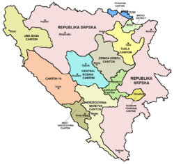
The Tuzla Canton[1] (Bosnian: Tuzlanski kanton[1]) is the third of 10 cantons of the Federation of Bosnia and Herzegovina, one of two entities in Bosnia and Herzegovina. The cantonal seat is in Tuzla.
Municipalities
The Tuzla Canton comprises the municipalities of Banovići, Čelić, Doboj Istok (Doboj East), Gradačac, Gračanica, Kladanj, Kalesija, Lukavac, Sapna, Srebrenik, Teočak and Živinice, as well as the city of Tuzla.
History and culture
The canton was created by the Washington Agreement in 1994, and its boundaries defined by the Dayton Agreement in 1995. Tuzla Canton was called Tuzla-Podrinje Canton until February 1999. Podrinje means ‘region near the river Drina’ but as the river did not flow through the Canton, a name change was authorised.
The Srebrenik Fortress is Bosnia's best-preserved medieval fort, dating from 1333 and is located in Srebrenik. The Panonian lake is a famous holiday resort for tourists.
Tuzla is the hip hop center of the Balkans due to Edo Maajka, Frenkie and the first hip hop station in Bosnia, which is located in Tuzla, FMJAM. Music artist guitarist Emir Hot, pianist Bešlić, accordionist Emir Vildić and violinist Selma Dizdarević are also from Tuzla. Famous singers Selma Bajrami and Lepa Brena were both born in Tuzla
See also
References
- 1 2 3 4 5 The Constitution of the Tuzla Canton Official name of canton is Tuzla Canton
- ↑ "First release" (PDF). Federal Office of Statistics, Federation of Bosnia and Herzegovina. June 30, 2011.
Coordinates: 44°33′N 18°36′E / 44.550°N 18.600°E