Berkovići
| Berkovići Берковићи | |
|---|---|
|
View on Berkovići | |
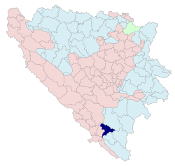 Location of Berkovići within Bosnia and Herzegovina | |
| Country | Bosnia and Herzegovina |
| Entity | Republika Srpska |
| Government | |
| • Mayor | Nenad Abramović (SDS) |
| Area | |
| • Total | 249,69 km2 (9,641 sq mi) |
| Population (2013 census) | |
| • Total | 2,272 |
| • Density | 9,1/km2 (240/sq mi) |
| • Municipality | ? |
| Time zone | CET (UTC+1) |
| • Summer (DST) | CEST (UTC+2) |
| Area code(s) | 59 |
| Website | http://www.opstinaberkovici.com/ |
Berkovići (Serbian Cyrillic: Берковићи) is a village and a municipality in southern Republika Srpska, Bosnia and Herzegovina.
Geography
The municipality is located in the westernmost part of East Herzegovina.
History
The municipality was created in 1995, after the Bosnian War, out of the Republika Srpska-controlled portions of the pre-war municipality of Stolac (now in Federation of B&H).
Demographics
The majority of the population of the municipality are Serbs.
In 1991, the population of the town of Berkovići numbered 159 people, including:
In 1991., the population of the municipality of Berkovići numbered 3,510 people, including:
- 2,111 (60.14%) Serbs
- 715 (20.37%) Bosniaks
- 646 (18.40%) Croats
- 27 (0.76%) Yugoslavs
- 11 (0.31%) others and unknown
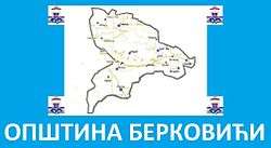
Settlements
Berkovići, Bitunja, Brštanik, Dabrica, Hatelji, Ljubljenica, Ljuti Do, Meča, Predolje, Poplat, Strupići, Selišta, Suzina, Šćepan Krst, Trusina and Žegulja, and parts of settlements: Barane, Burmazi, Do, Hodovo and Hrgud.
Economy
The municipality is underdeveloped and much of the economic activity is agricultural.
See also
External links
| Wikimedia Commons has media related to Berkovići. |
Coordinates: 43°07′N 18°04′E / 43.117°N 18.067°E