St. Charles, Minnesota
| St. Charles, Minnesota | |
|---|---|
| City | |
|
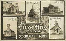
1910 postcard from St. Charles | |
| Nickname(s): Gateway to Whitewater | |
| Motto: City with a Smile | |
 Location of St. Charles, Minnesota | |
| Coordinates: 43°58′11″N 92°3′51″W / 43.96972°N 92.06417°W | |
| Country | United States |
| State | Minnesota |
| County | Winona |
| Government | |
| • Type | Mayor - Council |
| • Mayor | John Schaber[1] |
| • Administrator | Nick Koverman |
| Area[2] | |
| • Total | 3.86 sq mi (10.00 km2) |
| • Land | 3.86 sq mi (10.00 km2) |
| • Water | 0 sq mi (0 km2) |
| Elevation | 1,129 ft (344 m) |
| Population (2010)[3] | |
| • Total | 3,735 |
| • Estimate (2012[4]) | 3,699 |
| • Density | 967.6/sq mi (373.6/km2) |
| Time zone | Central (CST) (UTC-6) |
| • Summer (DST) | CDT (UTC-5) |
| ZIP code | 55972 |
| Area code(s) | 507 |
| FIPS code | 27-56788[5] |
| GNIS feature ID | 0650549[6] |
| Website | www.stcharlesmn.org |
St. Charles is a city in Winona County, Minnesota, United States. The population was 3,735 at the 2010 census.[7] It promotes itself as the gateway to Whitewater State Park, which is located 7 miles (11 km) north of the city on Minnesota State Highway 74.
History
St. Charles was laid out in 1854, and named for Saint Charles Borromeo (1538–1584), an Italian saint and cardinal.[8] A post office has been in operation at St. Charles since 1855.[9] St. Charles was incorporated in 1870.[8]
The city was evacuated on April 17, 2009, when a large fire at North Star Foods, a poultry processing plant, threatened anhydrous ammonia tanks.[10] Residents were allowed to return the next day.[11]
Geography and transportation
According to the United States Census Bureau, the city has a total area of 3.86 square miles (10.00 km2), all of it land.[2]
U.S. Highway 14 bisects the city from east to west, as does the Dakota, Minnesota and Eastern Railroad. Minnesota State Highway 74 goes through the city from south to north, running along Whitewater Avenue, also known as Main Street. A freeway entrance to Interstate 90 is immediately south of the city.
The Whitewater River runs through the northern part of the city.
Demographics
| Historical population | |||
|---|---|---|---|
| Census | Pop. | %± | |
| 1870 | 1,151 | — | |
| 1880 | 1,155 | 0.3% | |
| 1890 | 1,178 | 2.0% | |
| 1900 | 1,304 | 10.7% | |
| 1910 | 1,159 | −11.1% | |
| 1920 | 1,351 | 16.6% | |
| 1930 | 1,311 | −3.0% | |
| 1940 | 1,507 | 15.0% | |
| 1950 | 1,548 | 2.7% | |
| 1960 | 1,882 | 21.6% | |
| 1970 | 1,942 | 3.2% | |
| 1980 | 2,184 | 12.5% | |
| 1990 | 2,642 | 21.0% | |
| 2000 | 3,295 | 24.7% | |
| 2010 | 3,735 | 13.4% | |
| Est. 2015 | 3,709 | [12] | −0.7% |
| U.S. Decennial Census | |||
2010 census
As of the census[3] of 2010, there were 3,735 people, 1,416 households, and 985 families residing in the city. The population density was 967.6 inhabitants per square mile (373.6/km2). There were 1,532 housing units at an average density of 396.9 per square mile (153.2/km2). The racial makeup of the city was 91.8% White, 0.6% African American, 0.3% Native American, 2.5% Asian, 3.0% from other races, and 1.8% from two or more races. Hispanic or Latino of any race were 8.8% of the population.
There were 1,416 households of which 36.4% had children under the age of 18 living with them, 55.7% were married couples living together, 10.1% had a female householder with no husband present, 3.7% had a male householder with no wife present, and 30.4% were non-families. 26.2% of all households were made up of individuals and 12.5% had someone living alone who was 65 years of age or older. The average household size was 2.60 and the average family size was 3.15.
The median age in the city was 35.8 years. 28% of residents were under the age of 18; 7.9% were between the ages of 18 and 24; 26.3% were from 25 to 44; 22.8% were from 45 to 64; and 14.9% were 65 years of age or older. The gender makeup of the city was 49.6% male and 50.4% female.
2000 census
As of the census[5] of 2000, there were 3,295 people, 1,238 households, and 870 families residing in the city. The population density was 1,005.3 people per square mile (387.9/km²). There were 1,276 housing units at an average density of 389.3 per square mile (150.2/km²). The racial makeup of the city was 91.62% White, 0.97% African American, 0.27% Native American, 3.61% Asian, 0.09% Pacific Islander, 2.70% from other races, and 0.73% from two or more races. Hispanic or Latino of any race were 4.95% of the population.
There were 1,238 households out of which 37.8% had children under the age of 18 living with them, 58.1% were married couples living together, 9.2% had a female householder with no husband present, and 29.7% were non-families. 23.6% of all households were made up of individuals and 11.6% had someone living alone who was 65 years of age or older. The average household size was 2.61 and the average family size was 3.13.
In the city the population was spread out with 29.3% under the age of 18, 9.1% from 18 to 24, 28.9% from 25 to 44, 17.1% from 45 to 64, and 15.6% who were 65 years of age or older. The median age was 33 years. For every 100 females there were 95.1 males. For every 100 females age 18 and over, there were 92.5 males.
The median income for a household in the city was $42,813, and the median income for a family was $50,375. Males had a median income of $31,653 versus $23,173 for females. The per capita income for the city was $17,727. About 7.5% of families and 9.1% of the population were below the poverty line, including 11.5% of those under age 18 and 12.1% of those age 65 or over.
Education
St. Charles is part of the St. Charles School District and houses both the elementary and high school. There is also St. Charles Public Library.
Art and culture
The annual city festival is Gladiolus Days which is always held the weekend before labor day in August. It honors the late Carl H. Fischer, a local resident who developed many varieties of that flower. Fischer created a business called Noweta Gardens which developed hundreds of different varieties of Gladiolus. The community gained the title of "Gladiolus Capitol of the World".
Notable people
- Erastus Milo Cravath (1833–1900), field secretary with the American Missionary Association, spent his last years at St. Charles
- P/O Arthur Donahue (1913–1942), pilot who fought for the RAF and died during the Battle of Britain
- Carl H. Fischer (1907–2005), floriculturalist
- Brad Nessler, ESPN commentator
References
- ↑ "Mayor and Council". City of St. Charles, MN. Retrieved 4 January 2016.
- 1 2 "US Gazetteer files 2010". United States Census Bureau. Retrieved 2012-11-13.
- 1 2 "American FactFinder". United States Census Bureau. Retrieved 2012-11-13.
- ↑ "Population Estimates". United States Census Bureau. Retrieved 2013-05-28.
- 1 2 "American FactFinder". United States Census Bureau. Retrieved 2008-01-31.
- ↑ "US Board on Geographic Names". United States Geological Survey. 2007-10-25. Retrieved 2008-01-31.
- ↑ "2010 Census Redistricting Data (Public Law 94-171) Summary File". American FactFinder. United States Census Bureau. Retrieved 27 April 2011.
- 1 2 Upham, Warren (1920). Minnesota Geographic Names: Their Origin and Historic Significance. Minnesota Historical Society. p. 583.
- ↑ "Winona County". Jim Forte Postal History. Retrieved 15 August 2015.
- ↑ Behr, Kevin (2009-04-18). "St. Charles Evacuated: Fire increased risk of chemical release; residents forced from their homes". Winona Daily News.
- ↑ Liz, Riggs (18 April 2009). "St. Charles residents return home". Rochester Post-Bulletin. Retrieved 18 April 2009.
- ↑ "Annual Estimates of the Resident Population for Incorporated Places: April 1, 2010 to July 1, 2015". Retrieved July 2, 2016.
External links
 Historic Trinity Episcopal Church, now a city park
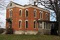 House of Hidden Treasure, one of the oldest homes in the city, now an antique shop
 North Star Foods the day after it was destroyed by fire
Municipalities and communities of Winona County, Minnesota, United States | ||
|---|---|---|
| Cities | 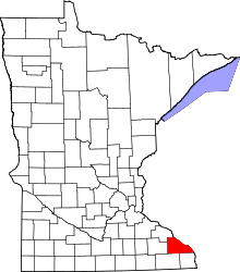 | |
| Townships | ||
| CDP | ||
| Unincorporated communities | ||
| Ghost towns | ||
| Footnotes | ‡This populated place also has portions in an adjacent county or counties | |
Coordinates: 43°58′18.84″N 92°3′53.64″W / 43.9719000°N 92.0649000°W