Sint-Truiden
| Sint-Truiden Saint-Trond (French) | |||
|---|---|---|---|
| Municipality | |||
|
Sint Truiden Grote Markt with eighteenth-century Stadhuis and Lievenvrouwenkerk | |||
| |||
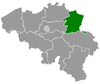
 Sint-Truiden Location in Belgium | |||
|
Location of Sint-Truiden in Limburg 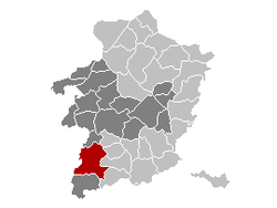 | |||
| Coordinates: 50°48′N 05°11′E / 50.800°N 5.183°ECoordinates: 50°48′N 05°11′E / 50.800°N 5.183°E | |||
| Country | Belgium | ||
| Community | Flemish Community | ||
| Region | Flemish Region | ||
| Province | Limburg | ||
| Arrondissement | Hasselt | ||
| Government | |||
| • Mayor | Veerle Heeren (CD&V) | ||
| • Governing party/ies | CD&V, Open VLD | ||
| Area | |||
| • Total | 106.90 km2 (41.27 sq mi) | ||
| Population (1 January 2016)[1] | |||
| • Total | 40,158 | ||
| • Density | 380/km2 (970/sq mi) | ||
| Postal codes | 3800, 3803, 3806 | ||
| Area codes | 011 | ||
| Website | www.sint-truiden.be | ||


Sint-Truiden (Dutch pronunciation: [sɪnt ˈtrœy̯də(n)]; French: Saint-Trond, French pronunciation: [sɛ̃ tʁɔ̃]) is a city and municipality located in the province of Limburg, Flemish Region, Belgium, near the towns of Hasselt and Tongeren. The municipality includes the old communes of Aalst, Brustem, Duras, Engelmanshoven, Gelinden, Gorsem, Groot-Gelmen, Halmaal, Kerkom-bij-Sint-Truiden, Melveren, Ordingen, Runkelen, Velm, Wilderen, and Zepperen.
The city is in the centre of Belgium's fruit producing region, Haspengouw (Hesbaye), and is renowned for its pears, apples (Jonagold), and sweet cherries.
History
Origins and Golden Age
The municipality formed around an abbey founded by St. Trudo, a Frankish nobleman, in the 7th century. Legend has it that as a boy, Trudo was playing while building a small church with some rocks. When a woman scornfully kicked over the rocks she was struck by sudden blindness. Trudo cured her from this blindness after she asked for his forgiveness. He also allegedly was able to spring water and cure other illnesses. After Trudo’s death, the abbey (the later Sint-Truiden Abbey) became the centre of a pilgrimage, which brought wealth to the neighbouring town. The 11th century was particularly prosperous and witnessed an important growth in population. This was the time when abbot Adelardus, reporting to the prince-bishop of Metz, built the abbey’s main church and two additional churches in town: Our Lady (Lievenvrouwenkerk) and Sint-Gangulfus. Under his direction, Sint-Truiden also received an earth wall surmounted by a wooden fence and fortified gates. A proper stone wall, gates and towers, were built in 1129. The economy of this new oppidum city was based on the linen industry and commerce with foreign lands such as England, Champagne, and Germany.
In the 13th century, the fortified town became one of the 23 bonnes villes (main cities) belonging to the Bishopric of Liège. A market hall was built at the site where the current city hall stands, the social life of the city was organized by the various guilds, and a perron was erected on the central square, symbolizing the local government’s authority in political affairs.
15th century until now
Charles the Bold captured the town in 1467, marking the beginning of a slow decline that lasted until the 19th century. The city’s fortifications were dismantled in 1675, and many of the religious congregations were disbanded under the French regime at the end of the 18th century. After 1830, these empty buildings were turned into educational and medical facilities. The city was also the centre of a prosperous agricultural region, which from the end of the 19th century became well known for its fruit production.
It occupied an important strategical position with regard to the N.E. frontier of Belgium, and General Henri Alexis Brialmont recommended its fortification.[2] On August 9, 1914, at the outset of Germany’s invasion of Belgium, 20 civilians were executed and a number of houses destroyed. The reconstruction and building of brand new neighbourhoods accelerated well into the 20th century.
During World War II, its airfield was the base of one of the most famous Luftwaffe Night Fighter squadron, NJG1, with units II/NJG1 and IV/NJG1 operating Junkers Ju88 and Heinkel He219 aircraft from here in 1944. The highest scoring German night fighter pilot, Heinz-Wolfgang Schnaufer (121 air victories, most of them on night) was referred to as "The spook of St. Trond" by British Bomber crews that flew over Germany on night raids. The airport EBST is still in use.
Transport
Air
The airport of Sint-Truiden, Limburg Regional Airport - EBST is PPR. The length of the runway is 1199 meters (3933 ft) and positioned as 06 - 24. Frequency is 119.975. It's a former air force base of the Belgian Air Force
Fuel (Jet A-1 and Avgas) are available. All is located in hangar 41 (turn right at the end of the runway when taxiing heading 06). Opening hours from 09:00 LT until sunset 7/7. There is also a flight school (airplane and helicopter) Fly One.
Rail
The town is served by Sint-Truiden railway station.
Sports
A football club is based in Sint-Truiden: K. Sint-Truidense V.V.
Places of interest
- Sint-Truiden’s historical centre includes the town hall (Stadhuis), with a 17th-century tower classified by UNESCO as a World Heritage Site in 1999. The oldest parts of the building date from the 13th century.
- The 15th-century Church of Our Lady (Lievenvrouwenkerk) stands just beside the town hall.
- The béguinage of Sint-Agnes, with its 13th-century church, was also classified by UNESCO as a World Heritage Site.
- An 11th-century Romanesque tower and crypt are all that remain of the old abbey of St Trudo. Several other Romanesque buildings can also be visited in town: Sint-Pieterskerk, Sint-Gangulfuskerk, and the Guvelingen chapel.
- On the abbey square stands the statue of St Trudo which, together with a meridian line traced on the ground, also functions as a sundial.
- Sint-Truiden offers several good examples of Baroque architecture, including the gable of the town hall and the Minderbroederkerk.
- The military school KSOO Saffraanberg.
Notable inhabitants
- Christina the Astonishing (1150–1224)
- Denis the Carthusian, theologian and mystic (1402–1471)
- Barthélémy de Theux de Meylandt, politician and former Belgian Prime Minister, born in Sint-Truiden (1794–1874)
- Aldous Huxley, English author (1894–1963), married Maria Nys from Sint-Truiden and briefly resided on the town's central square
- Désiré Collen (b. Sint-Truiden, 21 June 1943), physician and chemist.
- Frank De Winne, astronaut, born in Ghent in 1961, but residing in Sint-Truiden since 1986.
- Danny Boffin, football player (1965-)
- Ruud Boffin, football player
- Tina Bride (b. December 23, 1977), musician and dancer.
- Simon Mignolet (b. August 6, 1988), football player
- Koen Vanmechelen (b. August 26, 1965), artist
- Tim Wellens (b. May 10, 1991), cyclist
Sister cities
Sint-Truiden is twinned with the following cities:
-
 Duras, France
 -
 Weert, Netherlands
 -
 Nueva Guinea, Nicaragua
References
- ↑ Population per municipality as of 1 January 2016 (XLS; 397 KB)
- ↑
 Chisholm, Hugh, ed. (1911). "St Trond". Encyclopædia Britannica (11th ed.). Cambridge University Press.
External links
| Wikimedia Commons has media related to Sint-Truiden. |
- Official website (Dutch)
- Official news website (Dutch)
 |
Nieuwerkerken | Alken | | |
| Zoutleeuw (VBR) | |
Wellen Borgloon | ||
| ||||
| | ||||
| Landen (VBR) | Gingelom | Heers |