Staples, Texas
| Staples | |
|---|---|
| City | |
 Staples | |
| Coordinates: 29°46′53″N 97°50′10″W / 29.78139°N 97.83611°W | |
| Country | United States |
| State | Texas |
| County | Guadalupe |
| Incorporated | 2008 |
| Population (2000) | |
| • Total | 350 |
Staples is a city in northeastern Guadalupe County, Texas, United States. In an election held on May 10, 2008, its residents voted to incorporate the community as a city. A total of 125 votes were cast with 87 (69.6%) in favor of incorporation and 38 (30.4%) against.[1][2] The population is approximately 220[3] and it is part of the San Antonio Metropolitan Statistical Area.
The city held its first municipal election on November 4, 2008. Eddie Daffern, an organizer of the incorporation effort, was elected unopposed as Mayor. A total of seven candidates ran for the five Alderman positions.[4] Those elected include Carol Wester, who received 70 votes, followed by Ronnie Clark with 67 votes, Bert "Bubba" Reinke and William A. York – both winning 52 votes, and Shaun Seale with 40.[5]
As of 2000, Staples boasted a population of 350, containing a barber shop, two beauty shops, and a cafe.[6]
Demographics
| Historical population | |||
|---|---|---|---|
| Census | Pop. | %± | |
| 2010 | 267 | — | |
| Est. 2015 | 278 | [7] | 4.1% |
Education
Students living in Staples are zoned to schools in the San Marcos Consolidated Independent School District.
External links
- The Official Web Site of the City of Staples, Texas
- History of Staples, Texas
- Geographic Names Information System
References
- ↑ "Voters in Staples opt to become new city". Seguin Gazette-Enterprise. 2008-05-10. Retrieved 2008-06-01.
- ↑ "May 10, 2008 Staples Election" (PDF). Guadalupe County, Texas Elections Office. 2008-05-19. Retrieved 2008-06-01.
- ↑ "Welcome to the city of Staples?". Seguin Gazette-Enterprise. 2008-02-29. Retrieved 2008-06-01.
- ↑ "First council for new city looking forward". Seguin Gazette-Enterprise. 2008-11-06. Retrieved 2008-11-12.
- ↑ "November 4, 2008 Staples Special Election" (PDF). Guadalupe County, Texas Elections Office. 2008-11-05. Retrieved 2008-11-12.
- ↑ Staples at TSHA Online
- ↑ "Annual Estimates of the Resident Population for Incorporated Places: April 1, 2010 to July 1, 2015". Retrieved July 2, 2016.
- ↑ "Census of Population and Housing". Census.gov. Retrieved June 4, 2015.
Municipalities and communities of Guadalupe County, Texas, United States | ||
|---|---|---|
| Cities | 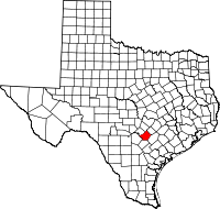 | |
| CDPs | ||
| Other unincorporated places |
| |
| Ghost towns |
| |
| Footnotes | ‡This populated place also has portions in an adjacent county or counties | |
Coordinates: 29°46′53″N 97°50′10″W / 29.78139°N 97.83611°W