Shavano Park, Texas
| Shavano Park, Texas | |
|---|---|
| City | |
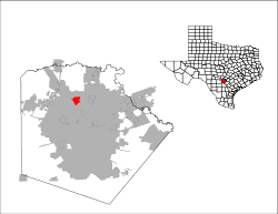
 Location of Shavano Park, Texas | |
| Coordinates: 29°35′9″N 98°33′16″W / 29.58583°N 98.55444°WCoordinates: 29°35′9″N 98°33′16″W / 29.58583°N 98.55444°W | |
| Country | United States |
| State | Texas |
| County | Bexar |
| Incorporated | June 19, 1956[1] |
| Area | |
| • Total | 3.34 sq mi (8.64 km2) |
| • Land | 3.33 sq mi (8.62 km2) |
| • Water | 0.004 sq mi (0.01 km2) |
| Elevation | 978 ft (298 m) |
| Population (2010) | |
| • Total | 3,035 |
| • Density | 911/sq mi (351.9/km2) |
| Time zone | Central (CST) (UTC-6) |
| • Summer (DST) | CDT (UTC-5) |
| ZIP code | 78231 |
| Area code(s) | 210, 726 (planned) |
| FIPS code | 48-67268[2] |
| GNIS feature ID | 1346987[3] |
| Website |
www |
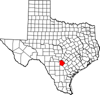
Shavano Park is an affluent city located in Bexar County, Texas, United States. As of the 2010 census, the population was 3,035,[4] up from 1,754 at the 2000 census. It is an enclave of San Antonio and is part of the San Antonio Metropolitan Statistical Area.
Geography
Shavano Park is located in north-central Bexar County at 29°35′9″N 98°33′16″W / 29.58583°N 98.55444°W (29.585859, -98.554471),[5] about 12 miles (19 km) north of downtown San Antonio. Shavano Park is entirely surrounded by the city of San Antonio; the northern border is formed by the Charles W. Anderson Loop outer beltway around San Antonio.
Despite lying in the far southeastern reaches of the Texas Hill Country, Shavano Park's terrain is flat to gently rolling. Most of the city is between 950 and 1,000 feet above sea level, which contrasts sharply with neighborhoods just north of Anderson Loop, where hills can rise 200 feet in a short distance. Some areas of San Antonio farther south have greater elevation variation despite not technically lying in the Hill Country. The east side of town forms a plateau looking over a cliff descending fifty feet or more. This cliff marks the boundary with San Antonio.
According to the United States Census Bureau, Shavano Park has a total area of 3.3 square miles (8.6 km2), of which 0.004 square miles (0.01 km2), or 0.14%, is water.[4]
Demographics
| Historical population | |||
|---|---|---|---|
| Census | Pop. | %± | |
| 1960 | 343 | — | |
| 1970 | 881 | 156.9% | |
| 1980 | 1,448 | 64.4% | |
| 1990 | 1,708 | 18.0% | |
| 2000 | 1,754 | 2.7% | |
| 2010 | 3,035 | 73.0% | |
| Est. 2015 | 3,527 | [6] | 16.2% |
As of the census[2] of 2010, there were 3,035 people, 629 households, and 549 families residing in the city. The population density was 990.9 people per square mile (382.6/km²). There were 652 housing units at an average density of 368.3 per square mile (142.2/km²). The racial makeup of the city was 92.87% White, 1.43% African American, 0.11% Native American, 2.17% Asian, 1.60% from other races, and 1.82% from two or more races. Hispanic or Latino of any race were 13.06% of the population.
There were 629 households out of which 35.1% had children under the age of 18 living with them, 82.2% were married couples living together, 4.6% had a female householder with no husband present, and 12.6% were non-families. 11.1% of all households were made up of individuals and 6.2% had someone living alone who was 65 years of age or older. The average household size was 2.79 and the average family size was 3.00.
In the city the population was spread out with 25.5% under the age of 18, 3.4% from 18 to 24, 18.1% from 25 to 44, 35.5% from 45 to 64, and 17.5% who were 65 years of age or older. The median age was 47 years. For every 100 females there were 94.5 males. For every 100 females age 18 and over, there were 92.2 males.
The median income for a household in the city was $108,306, and the median income for a family was $111,505. Males had a median income of $79,551 versus $41,250 for females. The per capita income for the city was $47,705. About 0.7% of families and 2.4% of the population were below the poverty line, including 3.0% of those under age 18 and 1.8% of those age 65 or over.
Education
Residents are zoned to schools in the Northside Independent School District.[8] Blattman Elementary School serves all of Shavano Park.[9] Blattman, which opened in 2003, was the first public school to be built in Shavano Park. The sole entrance and exit to the school is along Texas State Highway Loop 1604.[10] Blattman was built as part of the 2001 bond.[11] Prior to the opening of Blattman, Shavano Park was zoned to Locke Hill Elementary School in San Antonio.[12]
Hobby Middle School and Tom C. Clark High School, both in San Antonio, serve Shavano Park's middle and high school populations.[13][14]
Transportation
VIA Metropolitan Transit serves Shavano Park. The agency opened bus service to Shavano Park in August 2007, using route #97.[15]
Police department
The Shavano Park Police Department employs 19 police officers who serve 24 hours a day 365 days a year. All SPPD officers are commissioned Texas Peace Officers through the Texas Commission on Law Enforcement. As Texas Peace Officers they are empowered to enforce all federal, state, and local laws.
Fire department
The Shavano Park Fire Department is fully paid staff (17), working a 24/48 schedule. Manpower includes one full-time Chief/Fire Marshal, one Administrator, eight firefighter/paramedics, and seven fire/EMT personnel. Shavano Park Fire Department is equipped with two class A pumpers, two MICU level ambulances, one type-IV brush truck, two command vehicles, mobile air trailer and one SRT unit. The City of Shavano Park currently rate with an ISO score of 3.
References
- ↑ http://www.shavanopark.org/Town%20Projects/141027%20-%2010.1%20c%20Town%20Plan%20-%20FINAL.pdf
- 1 2 "American FactFinder". United States Census Bureau. Retrieved 2008-01-31.
- ↑ "US Board on Geographic Names". United States Geological Survey. 2007-10-25. Retrieved 2008-01-31.
- 1 2 "Geographic Identifiers: 2010 Demographic Profile Data (G001): Shavano Park city, Texas". U.S. Census Bureau, American Factfinder. Retrieved April 14, 2014.
- ↑ "US Gazetteer files: 2010, 2000, and 1990". United States Census Bureau. 2011-02-12. Retrieved 2011-04-23.
- ↑ "Annual Estimates of the Resident Population for Incorporated Places: April 1, 2010 to July 1, 2015". Retrieved July 2, 2016.
- ↑ "Census of Population and Housing". Census.gov. Retrieved June 4, 2015.
- ↑ "Overall City Map." City of Shavano Park. Retrieved on March 24, 2010.
- ↑ "Blattman Elementary Attendance Area." Northside Independent School District. Retrieved on March 24, 2010.
- ↑ "Newest campus to open Blattman Elementary is the first public school in Shavano Park." San Antonio Express-News. Sunday August 23, 2003. North Central Page 1H. Retrieved on March 24, 2010.
- ↑ "NISD Bond: New Schools." Northside Independent School District. April 14, 2003. Retrieved on March 25, 2010.
- ↑ "Attendance Zone for Blattman ES." Northside Independent School District. Retrieved on March 25, 2010.
- ↑ "Hobby Middle Attendance Area." Northside Independent School District. Retrieved on March 24, 2010.
- ↑ "Clark High Attendance Area." Northside Independent School District. Retrieved on March 24, 2010.
- ↑ "New Bus Route." City of Shavano Park. Retrieved on March 24, 2010.
