Ohio State Route 800
| ||||
|---|---|---|---|---|
|
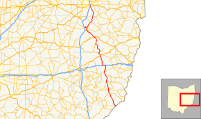
SR 800 highlighted in red | ||||
| Route information | ||||
| Maintained by ODOT | ||||
| Length: | 110.69 mi[1] (178.14 km) | |||
| Existed: | 1969 – present | |||
| Major junctions | ||||
| South end: |
| |||
|
| ||||
| North end: |
| |||
| Location | ||||
| Counties: | Monroe, Belmont, Guernsey, Harrison, Tuscarawas, Stark | |||
| Highway system | ||||
| ||||

State Route 800 (SR 800) is a north–south state highway in the eastern portion of the U.S. state of Ohio. Its southern terminus is at SR 7 in Jackson Township near New Matamoras, and its northern terminus is at its interchange with Interstate 77 in Canton.
Prior to 1969, SR 800 was part of SR 8. At that time, SR 8 between Akron and Canton was eliminated. The portion south of Canton was renumbered to SR 800.
History
Most of SR 800 was first designated in 1923 as SR 48 south of Dennison and SR 8 north of Dennison.[2][3] By 1927, the road from Fly to Dennison became a southern extension of SR 8.[4][5] Except for a realignment onto the US 250 expressway between Dennison and New Philadelphia in the 1960s, no major changes to the routing of SR 8 occurred between 1927 and 1969.[6][7]
In May 1968, the Ohio Department of Highways (predecessor to Ohio Department of Transportation) proposed the renumbering of SR 8 to SR 800.[8] The renumbering took place to avoid long conflicts with the newly constructed Interstate Highway System in Ohio.[9] SR 800 signs began appearing along the road in February 1969 with a six-month transition allowing for the removal of old SR 8 signs. The renumbering coincided with the renumbering of a section of SR 16 in the New Philadelphia area (it became SR 416).[9] Except for a realignment of the route around the north side of Dennison by 1979, no other changes have occurred to SR 800's routing.[10][11]
Major intersections
| County | Location | mi[1] | km | Destinations | Notes |
|---|---|---|---|---|---|
| Monroe | Jackson Township | 0.00 | 0.00 | ||
| Center Township | 14.55 | 23.42 | Western terminus of SR 255 | ||
| 15.46 | 24.88 | Southern end of SR 26 concurrency | |||
| Woodsfield | 17.77 | 28.60 | |||
| 17.92 | 28.84 | Northern end of SR 26 concurrency | |||
| Malaga Township | 25.16 | 40.49 | |||
| Belmont | Warren Township | 33.48 | 53.88 | Western terminus of SR 148 | |
| Barnesville | 35.82 | 57.65 | Southern end of SR 147 concurrency | ||
| 36.25 | 58.34 | Northern end of SR 147 concurrency | |||
| Kirkwood Township | 41.87– 42.08 | 67.38– 67.72 | Exit 202 (I-70) | ||
| Guernsey | Londonderry Township | 53.56 | 86.20 | Southern end of US 22 concurrency | |
| Harrison | Freeport Township | 54.17 | 87.18 | Northern end of US 22 concurrency | |
| Freeport | 57.48 | 92.51 | Eastern terminus of SR 342 | ||
| Freeport Township | 59.12 | 95.14 | Western terminus of SR 799 | ||
| Tuscarawas | Rush Township | 68.07 | 109.55 | Eastern terminus of SR 258 | |
| Union Township | 75.18 | 120.99 | Southern end of US 250 concurrency | ||
| Mill Township | 75.75 | 121.91 | North 2nd Street – Dennison | Interchange | |
| Uhrichsville | 76.55 | 123.20 | Interchange; eastern terminus of US 36 | ||
| 77.22 | 124.27 | Southern end of freeway | |||
| Midvale | 79.74 | 128.33 | |||
| Goshen Township | 81.49 | 131.15 | |||
| 83.62 | 134.57 | Northern end of US 250 concurrency; southern end of SR 416 concurrency | |||
| 83.62 | 134.57 | Northern end of freeway | |||
| New Philadelphia | 84.85 | 136.55 | Northern end of SR 416 concurrency; southern end of US 250 Bus. / SR 39 concurrency | ||
| 85.20 | 137.12 | Northern end of US 250 Bus. / SR 39 concurrency | |||
| Dover | 87.99 | 141.61 | Northern terminus of SR 211 | ||
| Dover Township | 90.75 | 146.05 | Northern terminus of SR 416 | ||
| Fairfield Township | 94.79 | 152.55 | Southern end of SR 212 concurrency | ||
| Sandy Township | 95.19 | 153.19 | Northern end of SR 212 concurrency | ||
| 99.97 | 160.89 | Western terminus of SR 183 | |||
| Stark | Canton | 109.96– 110.14 | 176.96– 177.25 | Exit 103 (I-77); access to I-77 south via Cleveland Avenue SW and Bolivar Road SW | |
1.000 mi = 1.609 km; 1.000 km = 0.621 mi
| |||||
References
- 1 2 "DESTAPE". Ohio Department of Transportation. July 16, 2013. Retrieved July 26, 2014.
- ↑ Map of Ohio State Highways Showing All Improved Roadways (MrSID) (Map). Cartography by E.C. Blosser. Ohio Department of Highways and Public Works. 1922. Retrieved August 18, 2013.
- ↑ Map of Ohio Showing State Routes (MrSID) (Map). Cartography by L.A. Boulay, Director. ODOH. 1923. Retrieved August 18, 2013.
- ↑ Map of Ohio Showing State Routes (MrSID) (Map). Cartography by G.F. Schlesinger, Director. ODOH. 1926. Retrieved September 22, 2013.
- ↑ Map of Ohio Showing State Routes (MrSID) (Map). Cartography by G.F. Schlesinger, Director. ODOH. 1927. Retrieved September 22, 2013.
- ↑ See the Wonderful World of Ohio (MrSID) (Map). Cartography by ODOH. ODOH. 1965. Retrieved September 2, 2013.
- ↑ See the Wonderful World of Ohio (MrSID) (Map). Cartography by ODOH. ODOH. 1966. Retrieved September 22, 2013.
- ↑ "State of Ohio Department of Highways Legal Notice". The Times-Reporter. June 10, 1968. p. 22. Retrieved August 13, 2014.
- 1 2 Staff (February 11, 1969). "State Route 8, 16 Are Changed". Coshocton Tribune. p. 4-B. Retrieved August 13, 2014.
- ↑ Official Ohio Highway Map (MrSID) (Map). Cartography by ODOT. Ohio Department of Transportation. 1978. Retrieved September 22, 2013.
- ↑ Official Ohio Highway Map (MrSID) (Map). Cartography by ODOT. ODOT. 1979. Retrieved September 22, 2013.