Sterling Hill Historic District (Plainfield and Sterling, Connecticut)
|
Sterling Hill Historic District | |
|
First Baptist Church of Sterling | |
  | |
| Location | Green Ln. and CT 14A, Plainfield and Sterling, Connecticut |
|---|---|
| Coordinates | 41°41′23″N 71°50′56″W / 41.68972°N 71.84889°WCoordinates: 41°41′23″N 71°50′56″W / 41.68972°N 71.84889°W |
| Architectural style | Greek Revival, Italianate, Federal |
| NRHP Reference # | 86000152[1] |
| Added to NRHP | February 6, 1986 |
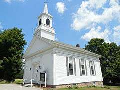
The Sterling Hill Historic District, located on the western edge of the town of Sterling, Connecticut, is a historic district that was listed on the National Register of Historic Places in 1986.[1] One house included in the district extends into the adjacent town of Plainfield. The district includes the Sterling Hill Baptist Church, from 1797, and 14 older and newer houses that include Greek Revival, Italianate, and Federal architecture.[2] The Dorrance Homestead, c.1716, is a combination of original house to the right of its large chimney, plus a later addition to the left, includes a Greek Revival entry.[2]
A portion of the Plainfield Pike (Connecticut Route 14A), a 3.6-mile (5.8 km) linear historic district noted for its traversal by the French Army in 1781 and 1782 and is also listed on the National Register, runs through the district. The French camped overnight in Sterling Hill, both in 1781 and in 1782.[2]
See also
- National Register of Historic Places listings in Windham County, Connecticut
- List of historic sites preserved along Rochambeau's route
References
- 1 2 National Park Service (2009-03-13). "National Register Information System". National Register of Historic Places. National Park Service.
- 1 2 3 Bruce Clouette; Matthew Roth & John Herzan (May 30, 1985). "National Register of Historic Places Inventory/Nomination: Sterling Hill Historic District" (PDF). National Park Service. and Accompanying 17 photos, from 1985
| Topics | |
|---|---|
| Lists by states |
|
| Lists by insular areas | |
| Lists by associated states | |
| Other areas | |
| |