Stow, Ohio
| Stow | |||
|---|---|---|---|
| City | |||
| City of Stow, Ohio | |||
|
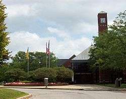
Stow City Hall | |||
| |||
 Location in Summit County and the state of Ohio. | |||
| Coordinates: 41°9′34″N 81°26′25″W / 41.15944°N 81.44028°WCoordinates: 41°9′34″N 81°26′25″W / 41.15944°N 81.44028°W | |||
| Country | United States | ||
| State | Ohio | ||
| County | Summit | ||
| Founded | 1804[1] | ||
| Incorporated | 1957[2] | ||
| Founded by | Joshua Stow | ||
| Government | |||
| • Mayor | Sara Kline [3] | ||
| Area[4] | |||
| • Total | 17.32 sq mi (44.86 km2) | ||
| • Land | 17.09 sq mi (44.26 km2) | ||
| • Water | 0.23 sq mi (0.60 km2) | ||
| Elevation | 1,093 ft (333 m) | ||
| Population (2010)[5] | |||
| • Total | 34,837 | ||
| • Estimate (2015[6]) | 34,797 | ||
| • Density | 2,038.4/sq mi (787.0/km2) | ||
| Time zone | EST (UTC-5) | ||
| • Summer (DST) | EDT (UTC-4) | ||
| ZIP code | 44224 | ||
| Area code(s) | 330, 234 | ||
| FIPS code | 39-74944[7] | ||
| GNIS feature ID | 1065392[8] | ||
| Website |
stow | ||
.jpg)
Stow is a city in Summit County, Ohio, United States. The population was 34,837 at the 2010 census and 34,797 at the 2015 estimate.[9] It is a suburban community within the Akron metropolitan area. Stow is adjacent to several other suburban communities in Summit and Portage counties. It is bordered on the south by the cities of Tallmadge and Munroe Falls and the village of Silver Lake, on the east by the city of Kent and Franklin Township, on the north by the city of Hudson, and on the west by the city of Cuyahoga Falls.
History
Stow is named for Joshua Stow, its original proprietor. Joshua Stow was a member of the party led by Moses Cleaveland to survey the lands of the Connecticut Western Reserve around present-day Cleveland in 1796. He was a native of Middletown, Connecticut, however, and never lived in Stow, though he spent both time and money developing the township and is quoted as saying it was "one of the prettiest and most romantic spots in the Western Reserve."[10] The land that would eventually be known as Stow Township was the survey township "Town 3, Range 10" of the Western Reserve and was initially 25 square miles (65 km2). It was purchased by Joshua Stow for $14,154. Prior to the arrival of European settlers, the area around what is now Stow was inhabited by a tribe of Seneca Native Americans at a small settlement in the area that is now part of the neighboring village of Silver Lake.[11][12]
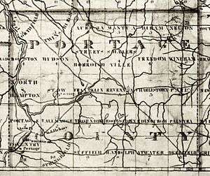
The first settler in Stow Township was William Walker, who arrived in 1802. Walker built a cabin just south of the land of his father Robert in Hudson Township mistakenly believing he was building in Hudson. In 1804, when Stow Township was separated from Hudson Township and surveyed into lots by Joseph Darrow, it was discovered his house was actually in Stow Township. Walker purchased the lot his home was on and continued to live there. Darrow had been hired by Joshua Stow's land agent William Wetmore, a settler also from Middletown, Connecticut, who moved to Stow in 1804 with his family and several other settlers. The Wetmores built a cabin in July 1804 near the center of Stow Township and the present-day intersection of Darrow Road and Kent Road. In 1808, the Wetmores built a home near the Seneca settlement in what is now Silver Lake. The house overlooked a small lake, known as Silver Lake since 1874, that was known earlier as Wetmore Pond or Stow Lake. Stow Township was formally organized in 1808 with the first election held in 1811. 1808 was also the year it was made part of the original Portage County. It remained as part of Portage County until it was included in the new Summit County in 1840.[11][13]
Most of the original 25-square-mile (65 km2) township is part of the present city of Stow, but parts of the original township form all or part of three neighboring communities. Munroe Falls was settled in 1809 as "Kelsey Mills" in the southern part of Stow Township and incorporated as a village in 1838. Cuyahoga Falls was developed on land owned by Wetmore and Joshua Stow beginning in 1825 in the southwestern part of the township and became a town in 1837. In 1851, Cuyahoga Falls Township was created, taking the southwest corner of Stow Township along with parts of three neighboring townships. Cuyahoga Falls incorporated as a village in 1868 and later annexed additional portions of Stow Township in the 19th and 20th centuries, as did Munroe Falls. Silver Lake incorporated as a village in 1918 on land that had previously been part of Stow Township. The remainder of Stow Township incorporated in 1957 as a village and became a city following the 1960 United States Census.[11][12][14]
Geography and climate
Stow is in east-central Summit County on the border with Portage County. It directly borders Kent to the east, Tallmadge and Munroe Falls to the south, and Cuyahoga Falls to the west and south. On the northwest corner, it touches Boston Township, with Streetsboro on the northeast corner and Brimfield Township on the southeast. According to the United States Census Bureau, the city has a total area of 17.32 square miles (44.86 km2), of which 17.09 square miles (44.26 km2) is land and 0.23 square miles (0.60 km2) is water.[4]
Stow's climate is classified as a humid continental climate in the Dfa Köppen climate classification meaning it typically has very warm, humid summers and cold, snowy winters, with moderate and variable spring and autumn seasons. The city is not considered part of the Lake Erie snowbelt, though lake-effect snow does occur at times. Stow is in the "secondary snowbelt," meaning it will receive heavier snowfalls from lake-effect snow when certain wind directions are more prevalent, but typically sees far less snow than areas to the north closer to Lake Erie.[15]
Demographics
| Historical population | |||
|---|---|---|---|
| Census | Pop. | %± | |
| 1960 | 12,194 | — | |
| 1970 | 19,847 | 62.8% | |
| 1980 | 25,299 | 27.5% | |
| 1990 | 27,702 | 9.5% | |
| 2000 | 32,139 | 16.0% | |
| 2010 | 34,837 | 8.4% | |
| Est. 2015 | 34,797 | [9] | −0.1% |
As of economic data accessed in 2013, those living under the poverty level in Stow has increased from 4.0% in 2007 to 7.5%. The employment status is 71% in the labor force, with an unemployment rate of 5.8%. There are 23.4% of the population receiving a mean Social Security income of $16,235 per year.[17]
Of the city's population over age 25, 40.6% hold a bachelor's degree or higher.[18]
2010 census
As of the census[5] of 2010, there were 34,837 people, 14,226 households, and 9,436 families residing in the city. The population density was 2,038.4 inhabitants per square mile (787.0/km2). There were 15,141 housing units at an average density of 886.0 per square mile (342.1/km2). The racial makeup of the city was 93.0% White, 2.7% African American, 0.1% Native American, 2.4% Asian, 0.3% from other races, and 1.4% from two or more races. Hispanic or Latino of any race were 1.5% of the population.
There were 14,226 households, of which 30.9% had children under age 18 living with them, 53.9% were married couples living together, 9.0% had a female householder with no husband present, 3.5% had a male householder with no wife present, and 33.7% were non-families. 27.2% of all households were made up of individuals, and 10.1% had someone living alone who was 65 or older. The average household size was 2.42, and the average family size was 2.97.
The median age in the city was 39.7 years. 22.7% of residents were under age 18; 8.1% were between 18 and 24; 26.8% were from 25 to 44; 28.6% were from 45 to 64; and 13.8% were 65 or older. The gender makeup of the city was 48.2% male and 51.8% female.
2000 census
As of the census[7] of 2000, there were 32,139 people, 12,317 households, and 8,745 families residing in the city. The population density was 1,878.1 people per square mile (725.2/km²). There were 12,852 housing units at an average density of 751.0 per square mile (290.0/km²). The racial makeup of the city was 95.20% White, 1.54% African American, 0.11% Native American, 1.91% Asian, 0.01% Pacific Islander, 0.30% from other races, and 0.93% from two or more races. Hispanic or Latino of any race were 0.91% of the population.
There were 12,317 households out of which 35.3% had children under the age of 18 living with them, 59.8% were married couples living together, 8.4% had a female householder with no husband present, and 29.0% were non-families. 23.7% of all households were made up of individuals and 8.0% had someone living alone who was 65 years of age or older. The average household size was 2.57 and the average family size was 3.08.
In the city the population was spread out with 26.0% under the age of 18, 7.4% from 18 to 24, 31.1% from 25 to 44, 23.5% from 45 to 64, and 12.0% who were 65 years of age or older. The median age was 37 years. For every 100 females there were 93.8 males. For every 100 females age 18 and over, there were 89.8 males.
Parks and recreation

Stow has several community parks including Adell Durbin Park, Meadowbrook Lake Park, Silver Springs Park, and Oregon Trail Park. Stow also owns Fox Den Golf Course.[19] Stow Parks and Recreation allows children and teenagers to participate in sports such as baseball and basketball. The tennis courts at Stow's parks are free to the public. The tennis courts at Adel Durbin Park are also lit for nighttime play.
Stow is also home to the Roses Run Country Club, which overlooks a section of the Cuyahoga River. In 2006 it was ranked the 18th most challenging 18-hole golf course in Northeast Ohio by the Northern Ohio Golf Association.[20] Fox Den Golf Course is another 18 hole 72 par golf course located in the eastern part of Stow and is owned and operated by the city of Stow. In 2009 it was named as one of the top-ten golf courses in Northeast Ohio by the Akron Beacon Journal.[21]
The 33.5-mile (53.9 km) Summit County MetroParks Bike and Hike trail runs through Stow beginning near the Pambi Farm Estates and Roses Run Country Club. The paved Bike & Hike Trail parallels a scenic section of the Cuyahoga River where great blue herons, Canada geese, ducks, turtles and white-tailed deer can be seen. The trail continues west through the neighboring cities of Munroe Falls and Silver Lake then continues north to Brandywine Falls, one of the highest waterfalls in Ohio. All 33.5 miles of the trail are paved and can be used for hiking, biking and rollerblading as well as cross-country skiing. Picnic areas can be found at numerous places along the trail.[22]
Education
Stow is served by the Stow-Munroe Falls City School District, along with most of neighboring Munroe Falls.[23] The district includes six elementary schools (Echo Hills, Fishcreek, Highland, Indian Trail, Riverview and Woodland), Lakeview Intermediate School, Kimpton Middle School and Stow-Munroe Falls High School. All of the district schools are in Stow except Riverview Elementary and Kimpton Middle School, which are in Munroe Falls.[24] Stow is served by Holy Family School for those wishing a Grade 1-8 Catholic education.
Media
Stow is served by a local newspaper — the Stow Sentry — published weekly by Record Publishing Co.[25] Maintained by the area division of Time Warner Cable, Stow also sponsors a Government-access television (GATV) station on cable TV — Stow Community Channel 15. The station broadcasts live audio from city council meetings, and regular announcements relating to: city and school functions; maintenance work; area businesses; and any upcoming local events.[26]
Transportation
Three Ohio state routes run through Stow: Ohio State Route 8, a limited-access highway; Ohio State Route 59 (Kent Road); and Ohio State Route 91 (Darrow Road). Both the Akron Metropolitan Regional Transit Authority (METRO RTA) and Portage Area Regional Transportation Authority (PARTA) have bus lines that stop in Stow,[27] and the city is also home to Kent State University Airport.[28]
Notable people
- Haley Bennett - singer, songwriter and actress
- Richard Cooey - convicted murderer and rapist; executed in 2008[29]
- Larry Csonka - former NFL football player; Pro Football Hall of Fame inductee
- Ben Curtis - professional golfer; winner of the 2003 British Open
- Ed Donatell - current secondary coach for the Chicago Bears
- Joe Ebanks - champion poker player
- Mark Gangloff - 2008 Olympian and gold medal winner
- Jim Graner - former weeknight sports anchor for WKYC; color commentator for Cleveland Browns radio network
- Dave Jamerson - former NBA basketball player
- Neel Kashkari - Interim Assistant Secretary of the Treasury for Financial Stability; led effort to purchase troubled financial assets under the Troubled Asset Relief Program (TARP)
- John Magaro - actor
- Shawn Porter - Professional Boxer boxing
- Erick Purkhiser - better known as Lux Interior, lead singer and founding member of The Cramps
- Jennifer Rohn - scientist and novelist
- Mike Vrabel - NFL football player
References
- ↑ "Timeline". City of Stow website. City of Stow. 2009. Retrieved 13 October 2009.
- ↑ Williams, Judith B. (1989). Stow Historic Preservation Plan. Stow, Ohio: City of Stow. p. 20.
- ↑ City of Stow - Mayor
- 1 2 "US Gazetteer files 2010". United States Census Bureau. Retrieved 2013-01-06.
- 1 2 "American FactFinder". United States Census Bureau. Retrieved 2013-01-06.
- ↑ "US Census QuickFacts". United States Census Bureau. Retrieved 2016-06-07.
- 1 2 "American FactFinder". United States Census Bureau. Retrieved 2008-01-31.
- ↑ "US Board on Geographic Names". United States Geological Survey. 2007-10-25. Retrieved 2008-01-31.
- 1 2 "Annual Estimates of the Resident Population for Incorporated Places: April 1, 2010 to July 1, 2015". Retrieved July 2, 2016.
- ↑ "Joshua Stow". Stow–Munroe Falls Public Library. Retrieved August 25, 2012.
- 1 2 3 Green, Frank A. (c. 1950). "Early History of Stow (adapted)". SMFPL.org. Stow-Munroe Falls Public Library (SMFPL). Retrieved August 25, 2012.
- 1 2 "Local History - Stow Timeline". SMFPL.org. Stow–Munroe Falls Public Library (SMFPL). 2005. Retrieved September 6, 2010.
- ↑ "William Wetmore". Stow–Munroe Falls Public Library. Retrieved August 25, 2012.
- ↑ History of Summit County (1972 reprint ed.). Chicago: Baskin and Battey. 1881. pp. 470–471.
- ↑ Johnson, Mark (November 12, 2010). "Where is northern Ohio's snow belt?". NewsNet5.com. NewsChannel 5. Retrieved August 6, 2013.
- ↑ "Census of Population and Housing". Census.gov. Retrieved June 4, 2015.
- ↑ Stow, Ohio Economic Census Data. Stow, Ohio (Report). ACS City Economic Data. June 18, 2013. Retrieved June 18, 2013.
- ↑ http://quickfacts.census.gov/qfd/states/39/3974944.html
- ↑ City of Stow - Parks and Recreation Home
- ↑ Roses Run Country Club
- ↑ Fox Den Golf Course
- ↑ Summit County MetroParks
- ↑ Exner, Rich (January 13, 2009). "Northeast Ohio property tax rates, and where the money goes". Cleveland.com. Cleveland Live, Inc. Retrieved August 6, 2010.
- ↑ "Stow-Munroe Falls City School District". SMFSchools.org. Stow-Munroe Falls City School District. 2010. Retrieved August 6, 2010.
- ↑ "The Stow Sentry Contacts List". StowSentry.com. Record Publishing Co, LLC. 2010. Retrieved September 6, 2010.
- ↑ "City of Stow Leaf Pick‐up Program (Curbside Vacuum Collection)" (PDF). City of Stow official website. City of Stow. 2009. Retrieved September 6, 2010.
For updates on the City of Stow Leaf Pick‐up Program... view Stow Community Channel 15 on Time Warner Cable.
- ↑ "Fall 2010 Maps & Schedules". AkronMetro.org. METRA RTA. 2010. Retrieved September 6, 2010.
- "County Service: InterUrban" (PDF). PARTAonline.org. PARTA. 2010. Retrieved September 6, 2010.
- ↑ McFarland, Maureen; Vincent, Emily (2010). "Aviation Heritage Fair Takes to the Skies for Its 15th Year". Kent.edu. Kent State University. Retrieved September 6, 2010.
... the Kent State University Airport, located at 4020 Kent Road in Stow, and the recently constructed Keegan Fetter Railroad
- ↑ Miller-Roane, Marilyn; Chancellor, Carl; Geiger, Peter (September 3, 1986). "3 Teens Held in Norton Rape-Murders: Jewelry, Weapon Recovered". Akron Beacon Journal. Beacon Journal Publishing Co. p. A1 - Metro.
A 1985 graduate of Stow High School, Cooey is a stepson of...
External links
| Wikimedia Commons has media related to Stow, Ohio. |
| Wikivoyage has a travel guide for Stow. |
Municipalities and communities of Summit County, Ohio, United States | ||
|---|---|---|
| Cities | 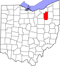 | |
| Villages | ||
| Townships | ||
| CDPs | ||
| Unincorporated communities | ||
| Footnotes | ‡This populated place also has portions in an adjacent county or counties | |