Sunraysia
| Sunraysia Australia | |||||||||||||
|---|---|---|---|---|---|---|---|---|---|---|---|---|---|
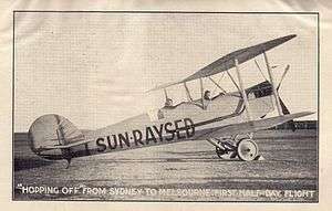 Jack De Garis promoting "Sun-Raysed", a coined word which later became "Sunraysia". | |||||||||||||
 An image showing the outline of the Mallee and Sunraysia district (red circle) which is predominantly contained within the Rural City of Mildura. | |||||||||||||
| LGA(s) | |||||||||||||
| State electorate(s) |
| ||||||||||||
| Federal Division(s) | |||||||||||||
| |||||||||||||
The Sunraysia is an ill–defined district, sometimes incorrectly referred to as an economic region,[1] located in northwestern Victoria and southwestern New South Wales in Australia. The region is renowned for its sunshine, intensive horticulture including grapes and oranges, and grain farms. Its main centre is Mildura, Victoria.
Etymology
The name Sunraysia is derived from a contest that entrepreneur Jack De Garis held as part of a promotion in 1919 on behalf of the Australian Dried Fruits Association. The public were invited to submit a name which described the dried fruits grown in the Mildura district. The winning name was Sun-Raysed, and this was extended to describe the district as Sunraysia. De Garis's 1920 established newspaper Sunraysia Daily borrowed the name accordingly.[2]
The area of Victoria to the west of Sunraysia is known as the Millewa, the main distinction being that Sunraysia is the irrigated area and Millewa is the dryland cropping area.
Pest Free Area
The Greater Sunraysia district forms part of the Fruit Fly Free Exclusion Zone, a Pest Free Area (PFA) that was created in 2007 located between north-west Victoria and south-west New South Wales. It is renowned for the production of high value horticultural crops including citrus, table grapes and stone fruit. The PFA is aligned to this production area to provide greater fruit fly control measures. The Victorian Department of Environment and Primary Industries (DEPI) and New South Wales Department of Primary Industries (DPI) have implemented stringent legislative controls on the movement of host fruit and vegetables into the PFA to keep it free from the Queensland fruit fly (QFF) and maintain high value markets, which are worth millions of dollars to local industries.[3] The PFA enables commercial horticultural products to be marketed without postharvest chemical treatments for QFF. The PFA follows the course of the Murray River from Kerang to Wentworth and the Darling River from Wentworth to Pooncarie.[4]
Sunraysia is mostly contained in the Murray Darling wine region.
Major centres and towns
In addition to Mildura, the other major centres and towns in the district are Merbein (Vic), Red Cliffs (Vic), Irymple (Vic), Wentworth (NSW) and Robinvale (Vic).
Education facilities
The Sunraysia Institute of TAFE and the Sunraysia campus of the La Trobe University, are located on Benetook Ave between 11th and 14th Streets.
Media
The main newspaper that services the region is the Sunraysia Daily, and is published every day except for Sundays. Sunraysia is also serviced by two free papers; the Mildura Midweek published on Wednesdays, the Mildura Weekly published on Fridays. The Mildura Independent was another free weekly, published from 1982 to 2007. My Mildura is a free monthly magazine. There are also a number of paid weeklies covering smaller areas within Sunraysia.
Local radio stations include ABC Local Radio, Easymix 1467 (1467AM 3ML), 97.9 3MA FM, 99.5 Star FM, and Hot FM.
Localised television stations in Sunraysia include a local relay of the ABC's Melbourne television station, WIN Television Mildura, PTV (a Prime7 affiliate) and Ten Mildura.
Gallery
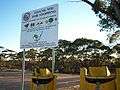 Fruit disposal bins and warning signs along the Calder Highway, approaching Mildura.
 Storage silo at Merrinee, Victoria.
See also
Notes
- ↑ The Balranald Shire is included in both the Sunraysia and the Riverina; hence the imprecise definition.
- ↑ The Rural City of Mildura is included in both the Sunraysia and the Mallee; hence the imprecise definition.
- ↑ The Murray Shire is included in both the Sunraysia and the Riverina; hence the imprecise definition.
- ↑ The Rural City of Swan Hill is included in both the Sunraysia and the Mallee; hence the imprecise definition.
- ↑ The Wakool Shire is included in both the Sunraysia and the Riverina; hence the imprecise definition.
References
- ↑ "Meaning of Regional Victoria". Department of State Development, Business and Innovation (MS Word requires download). Government of Victoria. 2011. Retrieved 15 August 2014.
- ↑ Kirkpatrick, Rod (30 November 2005). The regional daily unafraid to stand alone (PDF) (Thesis). University of Canberra.
- ↑ "Greater Sunraysia Pest Free Area". Department of Environment and Primary Industries and Department of Primary Industries. Government of Victoria and Government of New South Wales. Retrieved 16 August 2014.
- ↑ "Biosecurity: The Pest Free Area". Department of Primary Industries. Government of New South Wales. Retrieved 16 August 2014.
Coordinates: 34°12′22.17″S 142°08′08.61″E / 34.2061583°S 142.1357250°E