Tịnh Biên District
| Tịnh Biên District Huyện Tịnh Biên | |
|---|---|
| Rural district | |
 | |
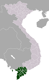
 Location in An Giang Province | |
| Country |
|
| Province | An Giang |
| Capital | Nhà Bàng |
| Area | |
| • Total | 130 sq mi (337 km2) |
| Population (2003) | |
| • Total | 115,901 |
| Time zone | Indochina Time (UTC+07:00) |
Tịnh Biên is a rural district (huyện) of An Giang Province in the Mekong Delta region of Vietnam.
As of 2003 the district had a population of 115,901.[1] The district covers an area of 337 km². The district capital lies at Nhà Bàng.[1]
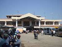
There is Tịnh Biên frontier market here.
Tịnh Biên is located about 125 km away from Phnom Penh along the National Highway 2 (CPC). It is a common route used by tourists between Cambodia and Vietnam. The Khmer population is relatively especially in the communes of An Cư, Tân Lợi, Hao An, Giao Va and Vĩnh Trung. Tịnh Biên District is connected by Highway 91 to Cần Thơ which also connects to Highway 1. and Highway 55 to Hà Tiên, about 80 km.
A village in the district was depicted in Robin Moore's fiction book The Green Berets; chapter 1 described a real-life battle at Tịnh Biên during the Vietnam War in which all of the members of a United States Army Special Forces detachment were injured during the fighting.[2]
Due to its proximity to the border with Cambodia, smuggling tobacco and electronic goods is operated in Tịnh Biên.
References
- 1 2 "Districts of Vietnam". Statoids. Retrieved March 13, 2009.
- ↑ McDowell, Jeffrey B. (May–June 2002). "The Search for Larry A. Thorne: Missing in Action, Vietnam". Military Review. 82 (3). ISSN 0026-4148. OCLC 2558412. Retrieved 7 May 2014. – via Questia (subscription required)
Coordinates: 10°34′59″N 105°00′00″E / 10.583°N 105.000°E