Teal Bend, Missouri
| Teal Bend, Missouri | |
|---|---|
| Unincorporated community | |
 Teal Bend, Missouri | |
| Coordinates: 38°17′05″N 93°28′52″W / 38.28472°N 93.48111°WCoordinates: 38°17′05″N 93°28′52″W / 38.28472°N 93.48111°W | |
| Country | United States |
| State | Missouri |
| County | Benton |
| Elevation | 866 ft (264 m) |
| Time zone | Central (CST) (UTC-6) |
| • Summer (DST) | CDT (UTC-5) |
| Area code(s) | 660 |
| GNIS feature ID | 738536[1] |
Teal Bend is an unincorporated community in Benton County, Missouri, United States. Teal Bend is located on Missouri Route 7 and the South Grand River 6.1 miles (9.8 km) west-northwest of Warsaw.[2]
References
- ↑ "Teal Bend". Geographic Names Information System. United States Geological Survey.
- ↑ Benton County General Highway Map (PDF) (Map). Missouri Department of Transportation. 2005. Retrieved May 24, 2012.
Municipalities and communities of Benton County, Missouri, United States | ||
|---|---|---|
| Cities | 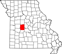 | |
| Village | ||
| Townships |
| |
| Unincorporated communities |
| |
| Former settlements | ||
| Footnotes | ‡This populated place also has portions in an adjacent county or counties | |
This article is issued from Wikipedia - version of the 5/13/2014. The text is available under the Creative Commons Attribution/Share Alike but additional terms may apply for the media files.