White Branch, Missouri
| White Branch, Missouri | |
|---|---|
| Unincorporated community | |
 White Branch, Missouri | |
| Coordinates: 38°14′04″N 93°21′17″W / 38.23444°N 93.35472°WCoordinates: 38°14′04″N 93°21′17″W / 38.23444°N 93.35472°W | |
| Country | United States |
| State | Missouri |
| County | Benton |
| Elevation | 699 ft (213 m) |
| Time zone | Central (CST) (UTC-6) |
| • Summer (DST) | CDT (UTC-5) |
| Area code(s) | 660 |
| GNIS feature ID | 728708[1] |
White Branch is an unincorporated community in Benton County, Missouri, United States. White Branch is located near Blue Branch and the junction of U.S. Route 65 and Missouri Route 83, 1.6 miles (2.6 km) east-southeast of downtown Warsaw.[2]
The community takes its name from nearby White Branch creek.[3]
References
- ↑ "White Branch". Geographic Names Information System. United States Geological Survey.
- ↑ Benton County General Highway Map (PDF) (Map). Missouri Department of Transportation. 2005. Retrieved May 26, 2012.
- ↑ "Benton County Place Names, 1928-1945 (archived)". The State Historical Society of Missouri. Retrieved 3 September 2016.
Municipalities and communities of Benton County, Missouri, United States | ||
|---|---|---|
| Cities | 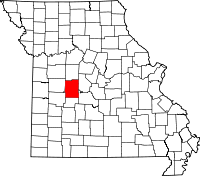 | |
| Village | ||
| Townships |
| |
| Unincorporated communities |
| |
| Former settlements | ||
| Footnotes | ‡This populated place also has portions in an adjacent county or counties | |
This article is issued from Wikipedia - version of the 9/3/2016. The text is available under the Creative Commons Attribution/Share Alike but additional terms may apply for the media files.