Teviot Range
| Teviot | |
|---|---|
| Flinders Peak group | |
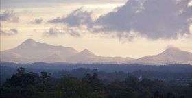 Teviot Range at Sunset, 2011 | |
| Highest point | |
| Peak | Flinders Peak |
| Elevation | 679 m (2,228 ft) |
| Geography | |
| Country | Australia |
| State | Queensland |
| Region | South East Queensland |
| Range coordinates | 27°55′S 152°45′E / 27.92°S 152.75°ECoordinates: 27°55′S 152°45′E / 27.92°S 152.75°E |
| Parent range | Scenic Rim |
---.JPG)
The Teviot Range, also referred to as the Flinders Peak Group, is a mountain range located on the northern edge of the Scenic Rim Region, south west of Logan City and south east of the City of Ipswich in South East Queensland, Australia.[1]
The first Europeans to cross the range were Patrick Logan and his exploration party in June 1827.[2] Most of the range remains naturally vegetated within a series of protected areas. Both the Flinders-Goolman Conservation Estate and the Flinders Peak Conservation Park are located along the Teviot Range.
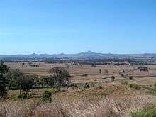
The summit in the Range is Flinders Peak reaching 679 m above sea level. Other mountains include Mount Joyce, Mount Blaine, Mount Goolman, Mount Elliott, Mount Flintoff, Mount Welcome and Ivorys Rock.[3] The range is visible from many locations around the Scenic Rim.
Landforms
| Landform | Height | Latitude | Decimal Degrees | Longitude | Decimal Degrees |
|---|---|---|---|---|---|
| Flinders Peak | 679 m | −27° 49′ 0″ S | −27.81667° | 152° 49′ 0″ E | 152.81667° |
| Mount Joyce | 469 m | −27° 54′ 0″ S | −27.9° | 152° 48′ 0″ E | 152.8° |
| Mount Blaine | 457 m | −27° 46′ 59″ S | −27.78333° | 152° 48′ 0″ E | 152.8° |
| Mount Goolman | 454 m | −27° 46′ 0″ S | −27.76667° | 152° 48′ 0″ E | 152.8° |
| Mount Elliott | 436 m[4] | −27° 49′ 0″ S | −27.81667° | 152° 49′ 0″ E | 152.81667° |
| Mount Flintoff | 351 m[4] | −27° 52′ 59″ S | −27.88333° | 152° 49′ 59″ E | 152.83333° |
| Mount Welcome | 341 m[4] | −27° 49′ 59″ S | −27.83333° | 152° 48′ 0″ E | 152.8° |
| Ivorys Rock | 309 m | −27° 46′ 0″ S | −27.76667° | 152° 47′ 0″ E | 152.78334° |
| Source: Geoscience Australia[5] | |||||
The southern-most mountain of the Range is Mount Joyce, which is separated from the Dugandan Range by Teviot Brook.[6]
History
The local Ugarapul people call Flinder's Peak, Booroong'pah or Booroongapah.[7][8] It is a sacred site because they believe that the powerful spirit, "Yurrangpul", lives there, and guards their traditions and sacred places. His name is similar to the local word for green tree frog: "Yurrang". The green tree frog is the totem of the Ugarapul people.[9] Mount Blaine is known to the Ugarapul people as Ginginbaar, and the Ugarapul meaning for Goolman, used in Mount Goolman, is Axe.[10]
Naming

Teviot Range derived its name after the River Teviot, Roxburghshire, Scotland, on 6 August 1828 by Allan Cunningham (1791–1839) botanist and explorer.[11][1] The landforms of the Range derived their names as follows:
- Flinders Peak was originally named High Peak in July 1799 by Lieutenant Matthew Flinders RN (1774–1814) navigator, hydrographer and scientist, HM Colonial Sloop Norfolk. The name Flinders Peak was first used by John Oxley (1785?-1828) Surveyor General during his explorations in 1824, as a change from High Peak of Flinders.[12]
- Mount Joyce, formerly known as Kents Peak, so marked on a map of the Moreton Bay District published in 1842 by Robert Dixon (1800–1858) surveyor.[13]
- Mount Blaine is probably named after John Blaine ( - ) who took up land near Peak Crossing in 1869 as the owner of Portion 89, Parish of Goolman.[14]
- Mount Goolman, formerly named by John Oxley as Murdoch Peak, is derived from the Yuggera language indicating stone axe. Murdoch Peak was probably named after Peter Murdoch, superintendent of the agricultural establishment at Emu Plains.[15][16]
- Mount Elliott is reportedly named after Robert Elliott who took up land in 1868.[17]
- Ivorys Rock is named after James Ivory (1820-1887) grazier, who held freehold land in the Bundamba and Teviot Range area.[18]
Water catchment
The Range drains into both the Bremer River Basin (sub-basin of Brisbane River Basin) and via Teviot Brook into the Logan River Basin (sub-basin of Logan-Albert River Basin). Teviot Brook is a major tributary of the Logan River that also supplies water to Wyaralong Dam.[19][20][21]
Land ownership and control
The Flinders-Goolman Conservation Estate is a collection of freehold and public land that is either owned or controlled by Ipswich City Council. Additionally, they are not protected areas dedicated under the Nature Conservation Act 1992.[22]
The Flinders Peak Conservation Park is entirely surrounded by (and separate from) the Flinders-Coolman Conservation Estate. The Conservation Park is controlled by the Queensland Department of Environment and Resource Management with the trustee being Ipswich City Council.[23][24]
The Flinders-Coolman Conservation Estate and the Flinders Peak Conservation Park do not cover the entire lands of the Teviot Range.
Public access
.jpg)
Flinders Peak track
Flinders Peak Track, used to access Flinders Peak, was closed to the general public by Ipswich City Council in November 2009 in the interest of public safety. One section of the track was deemed too difficult for the general public to negotiate so Council are endeavouring to re-align it for safer public access. All other tracks within the Estate have remained open.[25][26] Some social commentators question the reason why the Flinders Peak Track is closed.[27] It has since been reopened, with a slight detour of the area in question.
Boonah to Ipswich Trail
As of December 2010, the Queensland Department of Infrastructure and Planning were consulting stakeholders in regard to developing the Boonah to Ipswich Trail, a 68 kilometre multi-use non-motorised recreation trail, in partnership with five local Councils. The development of the Trail is in accordance with the South East Queensland Regional Trails Strategy (2007).[28] The 19 kilometres located within Ipswich City is planned to wind through the Flinders Goolman Conservation Estate and also will be the northern terminus of the Trail.[22] At the foot of Mount Joyce against Teviot Brook a recreation park is planned to incorporate the Boonah to Ipswich Trail.[29]
See also
References
- 1 2 "Teviot Range (entry 33769)". Queensland Place Names. Queensland Government. Retrieved 28 August 2015.
- ↑ Murray Johnson and Kay Saunders. "Working the Land:An Historical Overview of Boonah and its Northern Districts" (pdf). State of Queensland. p. 9. Retrieved 16 July 2009.
- ↑ NSW Northern Rivers & South-East Queensland (Map) (2 ed.). 1 : 550,000. Cartography by Auslig. NRMA. 1998.
- 1 2 3 Australian Road Atlas. Penguin Books Australia. 1996. (accessed 12 May 2011)
- ↑ Geoscience Australia, Place Name Search (accessed 12 May 2011)
- ↑ Wyaralong Dam Project, Queensland Department of Local Government & Planning (accessed 11 May 2011)
- ↑ "Here's the Answer", The World's News, 14 September, 1940, p.37
- ↑ "Aboriginal pathways in southeast Queensland and the Richmond River" by John Gladstone Steele. Published by University of Queensland Press, St. Lucia, Queensland, 1984
- ↑ (accessed 26 January, 2016)
- ↑ "Aboriginal pathways in southeast Queensland and the Richmond River" by John Gladstone Steele. Published by University of Queensland Press, St. Lucia, Queensland, 1984
- ↑ Steele, J.G., 1972, The explorers of the Moreton Bay District 1770-1830, pp.251,270, Brisbane
- ↑ Steele, J.G., 1972, The explorers of the Moreton Bay District 1770-1830, pp.9,89, Brisbane
- ↑ "Mount Joyce (entry 33769)". Queensland Place Names. Queensland Government. Retrieved 28 August 2015.
- ↑ "Mount Blaine (entry 3135)". Queensland Place Names. Queensland Government. Retrieved 28 August 2015.
- ↑ Steele, J.G., 1972, The explorers of the Moreton Bay District 1770-1830, p.117, Brisbane
- ↑ "Mount Goolman (entry 14249)". Queensland Place Names. Queensland Government. Retrieved 28 August 2015.
- ↑ "Mount Elliott (entry 11554)". Queensland Place Names. Queensland Government. Retrieved 28 August 2015.
- ↑ "Ivorys Rock (entry 16902)". Queensland Place Names. Queensland Government. Retrieved 28 August 2015.
- ↑ Surface Water Management Area Brisbane River, Australian Natural Resources Atlas, Australian Government (accessed 10 May 2011)
- ↑ Drainage Basin Logan-Albert River, Australian Natural Resources Atlas, Australian Government (accessed 10 May 2011)
- ↑ Bremer Catchment, City of Ipswich
- 1 2 "Boonah to Ipswich Trail Draft Plan" (PDF). Ipswich City Council. Section Flinders Goolman Conservation Estate (section 3.1, pp.11-12). Queensland Department of Infrastructure and Planning. December 2010. Retrieved 10 May 2011.
- ↑ Nature Conservation Legislation Amendment Regulation (No.1) 1997, Nature Conservation Act 1992 (accessed 10 May 2011)
- ↑ Conservation Parks, National Parks Association of Queensland Inc., 2008 (accessed 10 May 2011)
- ↑ Flinders Peak Track Closed, Media Release, City of Ipswich, 9 November 2009 (accessed 10 May 2010)
- ↑ Flinders Goolman Conservation Estate - Flinders Plum Picnic Area, Parks Search, City of Ipswich, 9 November 2009 (accessed 10 May 2010)
- ↑ Flinders Peak Closed Indefinitely, Queensland Climbing (accessed 10 May 2010)
- ↑ Boonah to Ipswich Trail, Queensland Department of Local Government & Planning, 03 May 2011 (accessed 16 June 2011)
- ↑ Mt Joyce Recreation Park, Queensland Water Infrastructure (accessed 11 May 2011)
External links
- Trails Guide, Flinders Goolman Conservation Estate, City of Ipswich
- Flinders-Coolman Conservation Estate, City of Ipswich
- Conservation Areas & Waterways, City of Ipswich
- Regional Map, Scenic Rim Regional Council