Beechmont, Queensland
| Beechmont Queensland | |||||||||||||
|---|---|---|---|---|---|---|---|---|---|---|---|---|---|
 | |||||||||||||
 Beechmont | |||||||||||||
| Coordinates | 28°6′S 153°13′E / 28.100°S 153.217°ECoordinates: 28°6′S 153°13′E / 28.100°S 153.217°E | ||||||||||||
| Population | 791 (2011 census)[1] | ||||||||||||
| Postcode(s) | 4211 | ||||||||||||
| LGA(s) | Scenic Rim Region | ||||||||||||
| State electorate(s) | Beaudesert | ||||||||||||
| Federal Division(s) | Wright | ||||||||||||
| |||||||||||||
Beechmont is a town and locality in the Scenic Rim Region, Queensland, Australia.[2][3] It is located in the Gold Coast hinterland of eastern Australia. At the 2011 census Beechmont recorded a population of 791.[1]
Geography
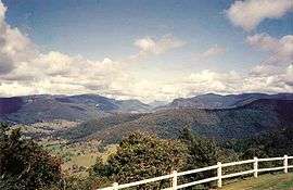
Beechmont is positioned on a forested ridge leading from the Lamington Plateau to Tamborine Mountain. Outstanding views in nearly all directions means that on a clear day Cunninghams Gap and other Scenic Rim landforms are visible as well as Flinders Peak, Moogerah Peaks and the D'Aguilar Range to the north west of Brisbane. Lower Beechmont is also on the Beechmont road, but slightly lower down the hill.
Roads in the area are narrow and windy, some are prone to rockfalls and some with very steep slopes. The road to Binna Burra and access to Lamington National Park goes through Beechmont. The Rosins Lookout Conservation Park is a popular launch site for hangliders and paragliders.
History
The Beechmont district was first occupied and managed by the Yugambeh people before the arrival of European timber cutters in the 1880s.[4][5] The district takes its current name from the beech trees in the area.[2]
The Beechmont State School opened on 15 August 1904.[6]
Attempts to grow fruit in the rich soils of the area were halted due to fruit fly infestations, before the area became to be known as a mountain tourist destination from the 1920s. There are still dairy farms operational in the area,[7][8] but only three remain in operation as the area is experiencing increasing levels of development.[9]
Heritage listings
Beechmont has a number of heritage-listed sites, including:
- Binna Burra Road: Binna Burra Cultural Landscape[10]
- 2-4 McInnes Court: Beechmont Church[11]
Education
Beechmont has a state school, Beechmont State School, which covers from preparatory school to year 7.
Infrastructure
There is a mobile phone tower near the village.[12] Internet is available with ADSL1 and ADSL2+ over copper lines. The Beechmont exchange is connected via a microwave link to the Telstra National Network. Beechmont is not listed on any of the National Broadband Network (NBN) fibre roll-out plans.
Tarred roads are available to Canungra and to Nerang. The roads are narrow and windy and sometimes closed or reduced to one lane passes after landslides and other rain induced incidents.
See also
References
- 1 2 Australian Bureau of Statistics (31 October 2012). "Beechmont (State Suburb)". 2011 Census QuickStats. Retrieved 20 September 2014.
- 1 2 "Beechmont (entry 2058)". Queensland Place Names. Queensland Government. Retrieved 28 March 2014.
- ↑ "Beechmont (entry 45110)". Queensland Place Names. Queensland Government. Retrieved 28 March 2014.
- ↑ "Lower Beechmont history". www.goldcoast.qld.gov.au. Gold Coast City Council. Retrieved 2016-01-25.
- ↑ Queensland Environmental Protection Agency (2000). Heritage Trails of the Great South East. State of Queensland. p. 19. ISBN 0-7345-1008-X.
- ↑ "Opening and closing dates of Queensland Schools". Queensland Government. Retrieved 28 March 2014.
- ↑ Genetics Australia: Queensland trials test controlled breeding using CIDRs
- ↑ Beechmont State School: Community
- ↑ Beechmount Mountain Sales: About Beechmont Plateau
- ↑ "Binna Burra Cultural Landscape (entry 601899)". Queensland Heritage Register. Queensland Heritage Council. Retrieved 12 July 2013.
- ↑ "Local Heritage Register" (PDF). Scenic Rim Regional Council. Retrieved 9 February 2015.
- ↑ Whirlpool Forum: Optus Tower Locations