Harlin
| Harlin Queensland | |
|---|---|
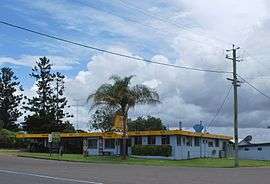 Harlin Hotel | |
 Harlin | |
| Coordinates | 26°58′0″S 152°21′0″E / 26.96667°S 152.35000°ECoordinates: 26°58′0″S 152°21′0″E / 26.96667°S 152.35000°E |
| Population | 534 (2011 census)[1] |
| Postcode(s) | 4306 |
| Location | |
| LGA(s) | Somerset Region |
| County | Cavendish |
| Parish | Colinton |
| State electorate(s) | Nanango |
| Federal Division(s) | Blair |
Harlin is a small town in south east Queensland, Australia. The town is on the Brisbane Valley Highway and the Brisbane River, 131 kilometres (81 mi) north west of the state capital, Brisbane. At the 2011 census, Harlin and the surrounding area had a population of 534.[1]
The town was marooned during the 2011 Floods. Over 40 travellers were stranded by the dangerous and rising flood waters of the Brisbane River and the Ivory and Maronghi Creeks. They were housed by the publicans and owners of the Harlin Hotel and the Caltex service station from 9 January 2011, until the flooded creeks and rivers subsided.
History
Harlin Post Office opened by September 1907 (a receiving office had been open from 1905) and closed in 1989.[2]
Heritage listings
Harlin has a number of heritage-listed sites, including:
- over Ivory (formerly Maronghi) Creek: Harlin Rail Bridge[3]
- Sinnamons Lane: Yimbun Railway Tunnel[4]
 Harlin Rail Bridge
References
- 1 2 Australian Bureau of Statistics (31 October 2012). "Harlin (State Suburb)". 2011 Census QuickStats. Retrieved 15 May 2015.
- ↑ Premier Postal History. "Post Office List". Premier Postal Auctions. Retrieved 10 May 2014.
- ↑ "Harlin Rail Bridge (entry 602636)". Queensland Heritage Register. Queensland Heritage Council. Retrieved 12 July 2013.
- ↑ "Yimbun Railway Tunnel (entry 602637)". Queensland Heritage Register. Queensland Heritage Council. Retrieved 12 July 2013.
External links
![]() Media related to Harlin, Queensland at Wikimedia Commons
Media related to Harlin, Queensland at Wikimedia Commons