The Hill, New South Wales
| The Hill Newcastle, New South Wales | |||||||||||||
|---|---|---|---|---|---|---|---|---|---|---|---|---|---|
|
Beacon Tower, originally 7 m (23 ft) high was extended to 20 m (66 ft) in 1877 after the light had been obscured by the erection of a Wesley Parsonage. | |||||||||||||
| Coordinates | 32°55′54″S 151°46′34″E / 32.93167°S 151.77611°ECoordinates: 32°55′54″S 151°46′34″E / 32.93167°S 151.77611°E | ||||||||||||
| Population | 2,101 (2006 census)[1] | ||||||||||||
| • Density | 3,335/km2 (8,640/sq mi) | ||||||||||||
| Postcode(s) | 2300 | ||||||||||||
| Area | 0.63 km2 (0.2 sq mi)Note1 | ||||||||||||
| Time zone | AEST (UTC+10) | ||||||||||||
| • Summer (DST) | AEDT (UTC+11) | ||||||||||||
| Location | |||||||||||||
| LGA(s) | City of Newcastle[2] | ||||||||||||
| Region | Hunter[2] | ||||||||||||
| County | Northumberland[3] | ||||||||||||
| Parish | Newcastle[3] | ||||||||||||
| State electorate(s) | Newcastle[4] | ||||||||||||
| Federal Division(s) | Newcastle[5] | ||||||||||||
| |||||||||||||
| |||||||||||||
The Hill is an inner city, residential suburb of Newcastle, in the Hunter Region of New South Wales, Australia, located immediately south of Newcastle's central business district.[2][6] The Hill is filled with historic Victorian terraces and is the site of a historic convict prison block.
As of January 2009, the average house price in The Hill was about A$537,500.[7]
Image gallery
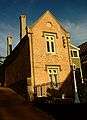 Residence building, which is part of St. Mary's Star of Sea Church
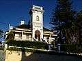 Jesmond House is a grand mansion of the 1880s with significant historic associations with Newcastle.
 Looking east from Jesmond House with Nobbys Head and Stockton Beach in the background.
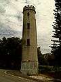 The obverse face of beacon tower, which was used as a navigational aid. Alterations to the bearings of the entrance channel led to commissioning of new lights in steel towers on other sites on 1 June 1918
 Christchurch Cathedral.
Notes
- ^ Area calculation is based on 1:100000 map 9232 NEWCASTLE.
References
- ↑ Australian Bureau of Statistics (25 October 2007). "The Hill (State Suburb)". 2006 Census QuickStats. Retrieved 2009-01-21. Map
- 1 2 3 "Suburb Search - Local Council Boundaries - Hunter (HT) - Newcastle City Council". New South Wales Division of Local Government. Retrieved 2009-01-21.
- 1 2 "The Hill". Geographical Names Register (GNR) of NSW. Geographical Names Board of New South Wales. Retrieved 2009-01-21.
- ↑ "Newcastle". New South Wales Electoral Commission. 24 March 2007. Retrieved 2009-01-21.
- ↑ "Newcastle". Australian Electoral Commission. 19 October 2007. Retrieved 2009-01-21.
- ↑ "The Hill". Land and Property Management Authority - Spatial Information eXchange. New South Wales Land and Property Information. Retrieved 2009-01-21.
- ↑ "The Hill suburb profile @ domain.com.au". domain.com.au. Retrieved 2009-01-21.
- "Newcastle Nobbys Signal Station AWS". Climate statistics for Australian locations. Bureau of Meteorology. Retrieved 2009-01-21.
This article is issued from Wikipedia - version of the 9/24/2016. The text is available under the Creative Commons Attribution/Share Alike but additional terms may apply for the media files.