Thomure, Missouri
| Thomure, Missouri | |
|---|---|
| unincorporated community | |
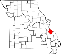 Location of Ste. Genevieve County, Missouri | |
| Coordinates: 38°0′14″N 90°3′34″W / 38.00389°N 90.05944°WCoordinates: 38°0′14″N 90°3′34″W / 38.00389°N 90.05944°W | |
| Country | United States |
| State | Missouri |
| County | Sainte Genevieve |
| Township | Ste. Genevieve [1] |
| Elevation | 387 [2] ft (118 m) |
| Time zone | Central (CST) (UTC-6) |
| • Summer (DST) | CDT (UTC-5) |
| ZIP code | 63670 |
| Area code(s) | 573 |
| FIPS code | 29-73078 [3] |
| GNIS feature ID | 741320 |
Thomure is an unincorporated community in Ste. Genevieve Township in eastern Sainte Genevieve County, Missouri, in the United States. It is situated about 2 miles north of Ste. Genevieve. Thomure was established as a railroad siding for river boats and ferries at Little Rock Landing on the Mississippi River. It was named for F. J. Thomure, superintendent of the Mississippi River and Bonne Terre Railroad. [4]
References
- ↑ "Hometownlocator.com". Retrieved October 2, 2016.
- ↑ "Mytopo.com". Retrieved October 2, 2016.
- ↑ "Roadsidethoughts.com". Retrieved October 2, 2016.
- ↑ "State Historical Society of Missouri – Ste. Genevieve Place Names, 1928-1945". Retrieved October 1, 2016.
Municipalities and communities of Sainte Genevieve County, Missouri, United States | ||
|---|---|---|
| Cities | | |
| Townships | ||
| CDPs |
| |
| Other communities |
| |
| Ghost towns | ||
This article is issued from Wikipedia - version of the 10/2/2016. The text is available under the Creative Commons Attribution/Share Alike but additional terms may apply for the media files.