Tihamah
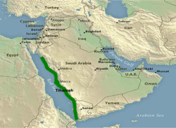
Tihamah or Tihama (Arabic: تهامة Tihāmah) refers to Red Sea coastal plain of Arabia from the Gulf of Aqaba to the Bab el Mandeb Strait.[1]
History
During Muhammad's era
During the Islamic prophet Muhammad's era, many military expedition took place here including the Invasion of Hamra al-Asad and the Caravan raids.
Beginning in January 623, some of the Muslims resorted to the tradition of raiding the Meccan caravans that traveled along the eastern coast of the Red Sea from Mecca to Syria. Communal life was essential for survival in desert conditions, as people needed support against the harsh environment and lifestyle. The tribal grouping was thus encouraged by the need to act as a unit. This unity was based on the bond of kinship by blood.[2] People of Arabia were either nomadic or sedentary, the former constantly traveling from one place to another seeking water and pasture for their flocks, while the latter settled and focused on trade and agriculture. The survival of nomads (or Bedouins) was also partially dependent on raiding caravans or oases, thus they saw this as no crime.[3]
While at Hamra al-Asad, Muhammad made an agreement with Mabad al-Khuzaah at Tihamah, in which Mabad pledged not to conceal anything from him. Mabad was then sent to Mecca to spread false information.[4] In Mecca, Mabad met with Abu Sufyan and spread disinformation that Muhammad had gathered a great force to fight Abu Sufyan. Abu Sufyan and his companions were planning a massive and decisive attack on Medina to finish off the Muslims once and for all. Hearing Mabad’s talk of the great military strength of Muhammad, Abu Sufyan retreated from his plan of an immediate attack on the Muslims. In this fashion Muhammad successfully managed to prevent the massive onslaught the Meccans were planning.[5][5][6]
Geography
The region is sometimes subdivided into two parts, Tihamat Al-Hejaz (northern part) and Tihamat ʿAsir (southern part).[1] The Yemeni part (Tihamat Al-Yaman) is an extension of Tihamat ʿAsir.[7] The plain is constricted and attains its greatest widths (60 to 80 km) south of Medina and south of Mecca.[1]
The cities of Yanbu, Jeddah and Al Qunfudhah are located in the Hejazi part of Tihamah. The Asiri -Yemeni part of the Tihamah plain includes the cities of Jizan and Al Hudaydah.
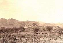
The temperatures in Tihamah are probably some of the hottest on earth. Tihamah in Arabic means severe heat and lack of wind.[8]
Flora
The extensive sandy coastal plain (the Tihamah) is a hot and inhospitable area parallel to the Red Sea, and most of it north of Zabid (Yemen) is devoid of trees. However, in a few places there is dense shrub composed almost exclusively of Acacia ehrenbergiana and it may be assumed that this was originally the dominant natural vegetation of the Tihamah. Salvadora persica occurs in thickets, and there are odd trees of Balanites aegyptiaca and colonies of wild doum palm (Hyphaene thebaica) and planted date palms (Phoenix dactylifera).[9]
Archaeology
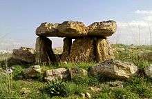
Over sixteen megalithic standing stones were discovered by Edward Keall, director of the Royal Ontario Museum's Canadian Archaeological Mission near the village of al-Mutaynah in the Tihamah area. The stones were made of granite and weighted up to 20 tonnes (20,000 kg). Three of the upright stones measured around 8 feet (2.4 m) tall with one fallen being over 20 metres (66 ft) in length. Copper tools suggested to date to the same era as the construction of the stones were dated to around 2400 to 1800 BCE. An even more archaic lithic industry was found along with pottery sherds that were dated between 1200 to 800 BCE.[10]
See also
| Wikimedia Commons has media related to Tihamah. |
Notes
- 1 2 3 "Arabia", on Encyclopaedia Britannica. Retrieved 20 March 2013 :
The Red Sea coastal plain is constricted throughout its length, attaining its greatest widths, 40 to 50 miles, south of Medina and south of Mecca. The name Tihāmah, used for the whole plain, is sometimes subdivided into Tihāmat Al-Ḥijāz and Tihāmat ʿAsīr.
- ↑ Watt (1953), pp. 16-18
- ↑ Loyal Rue, Religion Is Not about God: How Spiritual Traditions Nurture Our Biological,2005, p.224
- ↑ Al-Mubarakpuri, Saifur Rahman (2002), Sealed Nectar, Dar us Salam, p. 341
- 1 2 Habriel, Richard A (2005), Muhammad,Islams first Great general, Blackwell, p. 124, ISBN 978-0-8061-3860-2
- ↑ Al-Mubarakpuri, Saifur Rahman (2002), Sealed Nectar, Dar us Salam, p. 342
- ↑ "Yemen", on Encyclopaedia Britannica. Retrieved 20 March 2013 :
Yemen may be divided into five major regions: a coastal plain running north-south known as the Tihāmah (an extension of the Tihāmat ʿAsīr), the western highlands, the central mountains (the Yemen Highlands), the eastern highlands, and finally the eastern and northeastern desert regions.
- ↑ Dr. Shawqi Abu Khalil (2004). Atlas on the prophet's Biography. Darussalam. p. 31. ISBN 9960897710. Retrieved 20 March 2013. :
It is so called because of its severe heat and lack of wind, from the word At-Taham which refers to extreme heat and lack of wind.
- ↑ Hepper, F.N. (July 1978). "Were There Forests in the Yemen?". Proceedings of the Seminar for Arabian Studies. 9 (1979): 65–71. JSTOR 41223217. (registration required (help)).
- ↑ Harrington, Spencer., Yemeni Megaliths, Archaeology, the Archaeological Institute of America, December 10, 1997
Saudi Arabia articles | |||||||||||||
|---|---|---|---|---|---|---|---|---|---|---|---|---|---|
| History |  | ||||||||||||
| Geography | |||||||||||||
| Politics |
| ||||||||||||
| Economy | |||||||||||||
| Society |
| ||||||||||||
| |||||||||||||
Middle Eastern megaliths | ||
|---|---|---|
| Lebanon |
|  |
| Syria | ||
| Saudi Arabia | ||
| Israel | ||
| Jordan | ||
| Turkey | ||
| Egypt | ||
| Iran | ||
| Iraq | ||
| General articles | ||