Transport in Glasgow
The city of Glasgow, Scotland has a transport system encompassing air, rail, road, and an underground rail line. Prior to 1962, the city was also served by trams.
Airports
Glasgow has two international airports and also served by a seaplane terminal:
- Glasgow International Airport (GLA), formerly known as Abbotsinch, is the closest of the two international airports and handles the majority of Glasgow's air traffic. This includes shuttle flights to and from London and the rest of the UK, transatlantic links to New York, Philadelphia and several Canadian cities in addition to Dubai.
- Glasgow Prestwick International Airport (PIK) is located 29 miles south west of the city in South Ayrshire and caters mainly for charter flights, low-cost airlines, and freight traffic.
- Glasgow Seaplane Terminal, located on the River Clyde, by Glasgow Science Centre in the city centre.
There are also two small airfields in the nearby towns of Cumbernauld, and Strathaven, near East Kilbride.
Rail
Railway stations

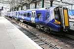
The city has two main line railway stations. Queen Street Station, located on the northern periphery of the city centre connects Glasgow to the North of Scotland, and Edinburgh. Glasgow Central station, located on Argyle Street is the northern terminus of the West Coast Main Line, and connects Glasgow with the South, and is the rail gateway to England and the rest of the UK. Regular express train services run from Central to London; terminating at either Euston or King's Cross.
There were two additional mainline stations serving the city at one stage. One, St Enoch Station, was sited at St Enoch Square not far from Central Station and parallel to the existing underground station of the same name, whilst the second, Buchanan Street Station was located at the northern end of Buchanan Street, approximately just north of where the Royal Concert Hall currently stands near to Queen Street Station. These two stations were removed in the 1960s as a result of the Beeching Axe. The St Enoch Shopping Centre was built on the site of St Enoch Station in the 1980s and Buchanan House (formerly ScotRail House) and part of the Glasgow Caledonian University campus now stand on the site of Buchanan Street Station.
Plans were devised in the post-war period to redevelop Glasgow as a whole. As part of the resulting "Bruce Report", it was proposed that Queen Street Station be demolished and replaced as a bus station and garage. Under this scheme only the low level Queen Street Station would be kept, as part of the suburban rail system, and a new purpose built Glasgow North Station would be constructed on the site of Buchanan Street Station. This plan was never followed through, and Queen Street operates to this day, although Buchanan Street Station closed in the 1960s. The chosen site for the Glasgow North Station is now occupied by the Buchanan Bus Station, the Buchanan Galleries shopping centre, the Royal Concert Hall and the Glasgow Passport Office. Glasgow and District Transport Plans from 1951 show the layout of the proposed station, available on: Hipkiss' Scanned Old Maps.
The Bruce Report also recommended the demolition of both Glasgow Central and St Enoch Stations and replacing them with a Glasgow South Station, but again this was never followed up.
Suburban rail
There is also a suburban above-ground rail system run by ScotRail to the specification and requirements of SPT, who provide rolling stock in the SPT livery of Carmine and Cream (as of 2012 being displaced by the standard ScotRail blue livery). It is centred on Central Station for the City south of the Clyde, the Ayrshire coast, and ferry ports on the Clyde. Queen Street Station is for links with Edinburgh and the east coast of Scotland and west to and north to the Highlands on the famous West Highland Line. The North Clyde Line runs from Helensburgh and Balloch in the west to Edinburgh, passing through Queen Street Station. The rail based urban and suburban systems are run by Strathclyde Partnership for Transport (SPT). SPT is formed and financed out of the twelve unitary authorities in the Greater Glasgow area including Glasgow City Council. It has responsibility for local train services, the Subway, certain ferries and buses. SPT runs the largest suburban rail network outside London, and incorporates 186 railway stations, 59 of them within Glasgow. There are links to East Kilbride, Airdrie, Coatbridge, Motherwell, Bathgate, Livingston, Hamilton, Newton Mearns, Paisley, Greenock, Milngavie, Neilston, Largs, Ardrossan, Cumbernauld, Helensburgh, Dumbarton, Balloch and Clydebank.
Future Plans
Locals have long pressed for a link which will join the two halves of the urban railway network together, making possible through journeys via the central area without having to disembark at either Central or Queen Street and traverse the city centre by foot or road. The Glasgow Crossrail initiative has been on the drawing board for many years, but still awaits funding from central government, despite the favourable outcomes of a feasibility study carried out in 2003.
Plans to connect Glasgow to London by a 270 mph Transrapid (German Maglev train) have emerged in June 2005. However, this proposal has now been shelved in favour of the proposed High Speed Two scheme from London to Birmingham, which may be extended to Glasgow.
There are also plans to connect Glasgow city with Glasgow International Airport, via a new rail link which it has been estimated will bring around 700 new jobs to the Paisley area. The Act of Parliament authorising construction of the link was passed by the Scottish Parliament on 29 November 2006 and received Royal Assent on 15 January 2007. It was expected that the link would be in operation by 2013 but it has recently been cancelled by the Scottish Parliament as a cost-cutting measure.
Major roads
The city is the focal point of Scotland's trunk road network and has many road connections to other cities. Glasgow has a less congested road network than Edinburgh, and the argument for congestion charging has not been as great. The city is linked to the rest of the country by the following main roads.
- A8/M8: Main east-west corridor which links Glasgow to Edinburgh, and Greenock to the west.
- A82: Dumbarton, Loch Lomond and the North West Highlands
- A80/M80: Stirling and the North East
- A77/M77: Kilmarnock, Ayr and the South West
- A74/M74: Main link to the South and England
City layout
The city centre is laid out on a grid plan, a result of the westward expansion from the old medieval core during the Georgian era, initially into the area now called the Merchant City. Much of the initial grid can be credited to a surveyor named James Barry. The desire to create a regular layout of streets fits in well with the Enlightenment ideas about rationality: at the same time, similar developments were taking place in Edinburgh, with the creation of the New Town. Despite this, the layout is not very regular, due to the awkward topography, with numerous drumlins, as well as the generation of point de vues out of the existing Palladian mansions in the Merchant City, all but one now demolished.
Inner Ring Road
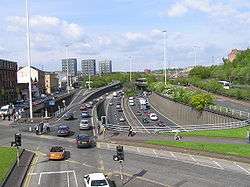
The aforementioned Bruce Report not only recommended the construction of two major new railway stations, but also the construction of an inner ring road of motorway that circled the city centre. Despite being proposed in the aftermath of the Second World War it was not until the 1960s that this project was begun. This involved the construction of the M8 motorway through the east end of the city along the route of the old Monkland Canal. This part of the project was fairly non controversial as the canal was in a poor state and not really in use by this time. This portion of the ring road would form the northern flank.
What was more controversial of the M8 was where it would form the western flank of the ring road, which involved the destruction of many properties in the Woodlands, Garnethill and Anderston areas, which have been left unrecognisable from the period the motorway was constructed. The ring road then continued across the Kingston Bridge over the River Clyde to the southside of the city.
This is where the ring road project was left incomplete. The M8 continues towards Greenock through the Southwest of Glasgow, but the ring road project was not finished as the M8 forms only the northern and western flanks of it. The plan called for an eastern and southern flank as well which were never put in place, even though turn offs on certain sections of the motorway were built to connect with these.
However, it seems that a southern portion will now be built as the Scottish Executive has determined that the M74 motorway will be extended through the Southeast of Glasgow to connect with the Kingston Bridge (although not along the original route identified in the Bruce Report). This is a controversial plan as it involves plowing the motorway through the city, something that many residents do not want, and a public enquiry recommended that construction not proceed. However the Executive contends that the economic benefits as well as congestion on the current motorway dictate that it will go ahead. Despite this, the opposers to the scheme mounted a legal challenge in June 2005, which will probably mean that opening of the extension will be delayed until 2009 at the earliest. The City Council have indicated that should this extension be complete they will reconsider building the eastern flank of the ring road which will necessitate either a second motorway bridge over the river, or a tunnel.
The ring road plan also called for a motorway out from the centre of the city to the north-west (as the ring road plan would have involved four motorways running off of the central ring - a northeast one, which is the M8 from Glasgow city centre to Edinburgh; a southwest one, which is the M8 from Glasgow city centre to Greenock; a southeast one, the projected M74 extension; and a northwest one, which would have left the Inner Ring Road at Woodside (slip road stubs are visible) and followed the path of the Forth & Clyde Canal up through the Maryhill area of Glasgow to Milngavie and beyond).
While there are no plans to build motorway-standard flank of the ring road at national government level, Glasgow City Council have recently published new plans for what it calls the Glasgow East End Regeneration Route (EERR). This would appear not to be a motorway, but instead an urban corridor which will connect the M74 extension at Polmadie with the M8/M80 at Provan. While the Council has openly voiced its commitment to the plan, it will likely face considerable controversy since its path will dissect the suburbs of Bridgeton, Carntyne and Parkhead making use of derelict land and an abandoned railway embankment. As of summer 2013, phases 1 and 2 of the project from the M74 to Parkhead have been completed. Phase 3 from Parkhead Forge to the M80 at Provan is scheduled for completion in 2014.
Glasgow Subway
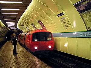
Glasgow is one of only three British metropolitan areas that has an underground metro system; the others being London and Tyne and Wear. The Glasgow Subway (previously Glasgow Underground), was built in 1896 and substantially modernised in 1977. It has a single circular route. This, taken together with the orange-coloured paintwork of the carriages, has led to it being known, by guidebooks more than the locals who still refer to it as the "Subway", as "The Clockwork Orange".
Despite being the third oldest subway system in the world (after London's and Budapest's), it has never been expanded beyond its original route. Reasons given for this have invariably related to Glasgow's geology: the tunnels are excavated from rock, and for this reason they are also smaller than London's. An SPT study into a possible expansion of the subway has been mooted. It would extend further into the West End, East End and Southside of the city which may cost up to £800million to build. Much of this expansion might utilise disused railway tunnels that have been abandoned since the Beeching cuts of the 1960s.
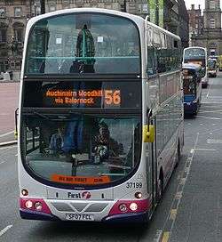
Bus
Deregulation of bus services began in October 1986, since that time bus operators have been able to start new services, change services, or cancel existing services by giving 42 days' notice to the relevant authorities; in Scotland this has since changed to 56 days notice with an additional 14-day consultation period over and above this. Operation of non commercial services that SPT deem to be socially necessary may be awarded by competitive tender.
A number of 'bus corridors' have been invested in by Glasgow City Council focusing on main bus routes with real time information, and bus priority measures. The Greater Glasgow Passenger Transport Executive (GGPTE), formerly the municipal transport operator, is now privately owned by First Glasgow.
The largest bus operators in the City are:
- First Glasgow - who are the successors to the former Glasgow Corporation Transport Department, and the former Central and Kelvin subsidiaries of the Scottish Bus Group.
- McGill's Buses - The successors to the former Arriva Scotland West. McGill's took over on the 26th of March 2012.
- Stagecoach Glasgow - The successors to the former Western subsidiary of the Scottish Bus Group, with their Stagecoach Glasgow company competing on several city routes.
- Glasgow Citybus - Independent company providing services in the North West Glasgow area.
Buchanan Bus Station is owned and run by SPT, and is a terminus for both local and long-distance services
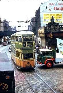
Trams
Glasgow had for many years an extensive system of trams that ran on the city's streets alongside other traffic. However, by the 1950s much of the vehicle stock was over 30 years old and in need of replacement. The trams were becoming less used as car use increased and gradually the tram network was phased out across the city, including many routes that were still fairly well used and reckoned to be economically viable. The last tram in the city ran on September 4, 1962 with as many as 250,000 people reckoned to have lined the streets to watch this spectacle.
In the mid 1990s there emerged a plan to create a Strathclyde Tram Project, which would have seen the reintroduction of trams to Glasgow. Strathclyde Passenger Transport published a set of plans for this system, going so far as to distribute pamphlets across the city outlining these plans and the proposed routes they were suggesting. The initial line proposed was a 20-kilometre route that would run from Maryhill in the Northwest of the city to Easterhouse on Glasgow's Eastern fringe. It was envisaged that the line would utilise disused railway lines and tunnels as well as running in part on some roads in the city alongside other traffic. The plan then outlined future expansion of the tram network so that it might one day stretch across the Greater Glasgow area.
However, there were a number of objections to these proposals, contentiously amongst them was an objection from Strathclyde Bus Holdings, who it could be argued did so out of fear of their profit margins being affected by such an initiative. This necessitated a public inquiry which lasted around 10 weeks. The Parliamentary Commissioners appointed to deliberate on the matter met and discussed the conclusions of this inquiry in a matter of hours before finding in favour of the objections raised thus killing off the Strathclyde Tram Project. The reasoning of the Commissioners is unknown as there existed no obligation from them to reveal it.[1]
There is a proposal to reintroduce trams (again, as in 1996, this would actually be a light rail system) to Glasgow. This came in light of similar proposals, completed in 2014, to reintroduce trams to Edinburgh. The City of Glasgow Council and SPT have commissioned a £500,000 study to see the viability of such a system which it is reckoned would initially operate from the city centre out to the new Glasgow Harbour site then across the River Clyde to the Southern General Hospital and through Govan and along the south bank of the Clyde before crossing the river again back into the city centre. There are proposals to run trams further than this route out to the Braehead shopping centre and possibly Glasgow Airport; to Clydebank; and across the rest of the city.
Presently SPT has decided that this route will not see trams running along it, but rather an "ultra-modern" bus service termed "Clyde Fastlink" will operate part of the route, running from the city centre to the Glasgow Harbour area.[2] SPT have stated however that they are leaving open the option of laying tram lines on this route and replacing the buses with a light rail system.
Trolleybuses
Glasgow Corporation Transport Department also operated a small trolleybus system between 1949 and 1967, using electricity generated from the same power station as the trams.
See also
Full bus, train and ferry information is available from Traveline Scotland
- Glasgow Transport employee uniform badges & history
- Bus, train, subway and walk map across the city and region
- Glasgow Corporation History Pages
References

| History |  | |
|---|---|---|
| Politics | ||
| Geography | ||
| Culture |
| |
| Transport | ||
| Education | ||
| Religion | ||
| Sport | ||
| Attractions |
| |
| Health | ||
Category | ||