Transportation in Philadelphia
Transportation in Philadelphia involves the various modes of transport within the city and its required infrastructure. In addition to facilitating intracity travel, Philadelphia's transportation system connects Philadelphia to towns of its metropolitan area and cities of the Boston-Washington megalopolis.
The city is crossed by the Delaware Expressway (I-95) and the Schuylkill Expressway (I-76), which are the principal thoroughfares for intercity traffic. The Vine Street Expressway (I-676) travels between I-76 and I-95 in Center City Philadelphia, and the Roosevelt Boulevard (US 1) carries crosstown traffic in northern Philadelphia.
Philadelphia's public transit system is mainly operated by the Southeast Pennsylvania Transportation Authority (SEPTA), which maintains an extensive system utilizing buses, rapid transit, commuter rail, trolleys, and the Philadelphia trackless trolley (trolleybus) system. The main rail station of Philadelphia is 30th Street Station, which has access to 13 SEPTA Regional Rail routes and 11 Amtrak intercity rail routes. Philadelphia International Airport, the primary airport of Philadelphia, is a hub for domestic and international aviation
Roads
Streets
Grid plan
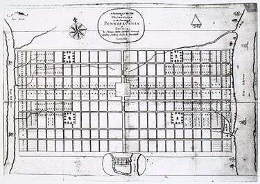
The streets of Philadelphia mainly follow a grid plan, one of the first such lay-outs used in a North American city. The grid plan originated in 1682, when William Penn founded Philadelphia and appointed Thomas Holme as his surveyor. Using 1,200 acres (4.9 km2),[1] Penn planned a system of organized streets to facilitate future growth. Since Penn survived the Great Fire of London and wanted to avoid similar catastrophes, he laid out streets wider than usual.[1] Penn planned the city to stretch between the Delaware and Schuylkill Rivers, and his grid plan of present-day Center City followed a 22-by-8-block pattern.[1] The plan included a large square in the center of the town (present day location of Philadelphia City Hall), and four public squares near each corner of the city.[1]
Since the initial grid covered only the area of present-day Center City, other settlements such as Kensington developed using different grids. The grid system was gradually extended to other regions of present-day Philadelphia, although several roads predating a grid system still exist. Certain neighborhoods of Philadelphia, such as those in the Far Northeast, do not use grid systems.
Names
When the street grid was designed by Penn, he named the east-west streets after trees (although four have since been renamed), and assigned the north-south streets numbers, starting with Front Street by the Delaware River. Market Street, running east-west, and Broad Street, running north-south, are the arteries of Center City, and originate from a loop around Philadelphia City Hall.
The naming system of the streets differs by neighborhood, although the main north-south streets are numbered in South Philadelphia, West Philadelphia, and Lower North Philadelphia similar to how they are numbered in Center City. One example of a naming system is in South Philadelphia, where east-west streets use the surnames of former governors of Pennsylvania, starting with Reed Street and ending with Pattison Avenue. Many other streets are named after locally or nationally significant people. During the 1900s, several streets were renamed to honor individuals, such as John F. Kennedy Boulevard.
Addresses
The system for assigning street addresses was enacted in 1858.[2] In areas with a consistent grid, the street address numbers increase by intervals of 100s for each block,[2] starting with Front Street for east-west streets and Market Street for north-south streets. For example, 1200 South Street would refer to the intersection of 12th & South Street, and 500 North 17th Street is 5 blocks north of Market Street.
Expressways

Philadelphia has a limited system of expressways, partly due to the "freeway revolts" of the 1960s and 1970s. Several planned crosstown freeways were cancelled due to local opposition, particularly from neighborhoods which would have been displaced by the freeways. One of the proposed freeways was Interstate 695, which would have run along South Street from the Delaware waterfront to the Schuylkill River as the "Crosstown Expressway",[3] and continue through Southwest Philadelphia to Interstate 95 as the "Cobbs Creek Expressway".[4] Although the Roosevelt Boulevard was proposed to be fully converted to an expressway, only the portion between Broad Street and the Schuylkill Expressway is built to freeway standards.
The main expressways of Philadelphia are the Delaware Expressway (I-95), which travels along the Delaware River, and the Schuylkill Expressway (I-76), paralleling the Schuylkill River for most of its route. Other expressways are the Vine Street Expressway (I-676), running between the Schuylkill Expressway and Delaware Expressway through downtown Philadelphia, and the Roosevelt Expressway (US 1), a freeway portion of the Roosevelt Boulevard.
Bridges
Delaware River
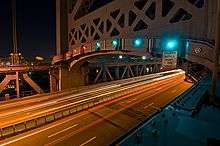
Philadelphia is connected to New Jersey across the Delaware River by four bridges, three of which are maintained by the Delaware River Port Authority. The oldest is the Benjamin Franklin Bridge, which opened in 1926, and was the world's longest suspension bridge span until the opening of the Ambassador Bridge in 1929.[5] The Ben Franklin Bridge connects Camden, New Jersey with Center City, thus making it a main crossing between Philadelphia and New Jersey. The Benjamin Franklin Bridge carries seven lanes of roadway, two rail lines of the PATCO Speedline, and two pedestrian walkways.
The longest bridge between Philadelphia and New Jersey is the Walt Whitman Bridge, which connects South Philadelphia to Gloucester City, New Jersey. The Walt Whitman Bridge opened in 1957, with a total length of 11,981 feet (3,652 m) and main span length of 2,000 feet (610 m).[6] The bridge carries seven lanes of I-76, and carries approximately 120,000 vehicles per day.[6]
Connecting to Northeast Philadelphia are the Betsy Ross Bridge, a six-lane bridge linking the Bridesburg neighborhood of Philadelphia with Pennsauken, New Jersey, and the Tacony–Palmyra Bridge, a three-lane drawbridge spanning the Delaware River between the Tacony neighborhood of Philadelphia and Palmyra, New Jersey.
Schuylkill River
The Schuylkill River, a main tributary of the Delaware River, is crossed by 20 roads in Philadelphia. The oldest bridges were built and operated by private companies, and were initially wooden until the advent of iron and steel bridges. The Market Street Bridge, opened in 1805,[7] was the first permanent bridge across the Schuylkill River. West Philadelphia has many bridges spanning across the Schuylkill River, including three expressways. University City is connected to Center City by five surface roads.
Pedestrians and bicycling

37% of Philadelphia workers commute without a car, compare to 33% for Chicago and 45% for San Francisco. According to a UC Berkeley study, 13 percent of Philadelphia households do not own a car.[8] Philadelphia also has recently expanded their network of bike lanes and has implemented a bike sharing network, Indego which debuted on April 23, 2015 with 60 stations and 600 bikes.
Underground transit concourse
Philadelphia has a 3.5-mile (5.6 km)[9] underground transit concourse in Center City, which connects the SEPTA Regional Rail lines with local rail and trolley lines. Throughout the entire concourse are underground entrances to adjacent buildings, as well as the "MetroMarket," a group of small shops and eateries near Suburban Station. Within the underground concourse, it is possible to walk between 8th Street & Market and 18th Street & JFK Boulevard, or from City Hall to Locust Street.
Trails
Philadelphia has several multi-use river trails. A segment of the Schuylkill River Trail passes along the Schuylkill River from Locust Street northward to Valley Forge, near King of Prussia Mall. In Philadelphia, most of the trail runs through Fairmount Park. The trail to Valley Forge totals 10.5 miles (16.9 km),[10] and when completed, will total 140 miles (230 km) to Hamburg, Pennsylvania.
The Wissahickon Trail branches off from the Schuylkill River Trail and runs along the Wissahickon Creek, terminating near Germantown Avenue. The Pennypack Trail runs along the Pennypack Creek, from the Delaware River to Fox Chase Farm. Sections of the Cobbs Creek and Tacony Creek also have trails.
Buses
SEPTA

SEPTA lists 117 bus routes[11] throughout Southeastern Pennsylvania, with most routes being within Philadelphia. Some of SEPTA's bus routes run 24 hours a day ("Night Owl" service), although most routes end by late night. SEPTA's bus service consists of its City Division for routes within Philadelphia, Victory ("Red Arrow") Division for routes in Chester, Delaware, and Montgomery Counties, and its Frontier Division for buses to Montgomery and Bucks Counties. Other bus routes are its Regional Rail connector routes, the "Night Owl" bus service replacing the Market-Frankford and Broad Street subway lines during their closure, and other specialized services. SEPTA leases buses for third-party charter routes, and runs the charter buses for the School District of Philadelphia.
The City Transit Division runs 76 bus routes (including three trackless trolley routes), and the Suburban Division runs 44 bus routes. In 2009, SEPTA had a fleet of 1153 revenue buses for its City Transit Division, and 262 revenue buses for its Suburban Division.[12]
Trackless trolley (trolleybus)
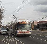
SEPTA currently operates trackless trolleys on Routes 59, 66, and 75. Routes 59 and 75 are connected to the Market-Frankford Line at Arrott Transportation Center Station, near the terminus of the Market-Frankford Line. Route 59 travels primarily along Castor Avenue through Northeast Philadelphia, and terminates at the end of Castor Avenue, near Pennypack Park. Route 75 travels along Wyoming Avenue, and connects to Wyoming Station of the Broad Street Line, ending at Wayne Junction in Nicetown. Route 66 connects to the Market-Frankford Line at the Frankford Transportation Center, and extends along Frankford Avenue to the extremity of Northeast Philadelphia.

SEPTA formerly ran trackless trolleys along Routes 29 and 79 in South Philadelphia, but replaced those services with diesel buses in 2003. In October 2006, the SEPTA board voted not to order additional vehicles for Routes 29 and 79, making them permanent diesel bus routes.[13]
Intercity bus stations
The primary intercity bus station in Philadelphia is the Philadelphia Greyhound Terminal, located in close proximity to The Gallery at Market East. Greyhound Lines operates its intercity buses from the Philadelphia Greyhound Terminal, which was the second busiest Greyhound bus station in the United States in 2008.[14] Greyhound Lines operates one-seat bus rides to a variety of destinations, including Washington, New York, Atlantic City, St. Louis, and Atlanta, and provides connecting service to other destinations via transfers.
Other private companies which operate from the Greyhound Bus Terminal are Bieber Tourways, Capitol Trailways, Martz Trailways, Peter Pan Bus Lines, and Susquehanna Trailways. MegaBus and BoltBus, both discount bus lines, operate out of 30th Street Station.
Chinatown buses, which travel between the Philadelphia Chinatown and Chinatowns in New York City and Washington, provide low-cost intercity bus service. In addition, China Airlines provides a private bus service to JFK International Airport in New York City to feed its flight to Taipei.[15]
New Jersey Transit
New Jersey Transit operates the 313, 315, 317 and 551 buses from the Greyhound Bus Terminal,[16] which service the New Jersey resort towns of Asbury Park, Atlantic City, and Cape May with intermediate stops throughout New Jersey. New Jersey Transit also operates two seasonal buses: the 316 express to Cape May and the 318 express to Six Flags Great Adventure.[16] Stopping on Market Street one block away from the terminal, New Jersey Transit operates 12 shorter, suburban routes to Burlington, Camden, and Gloucester Counties.[17]
Railroads


SEPTA Subway/Elevated
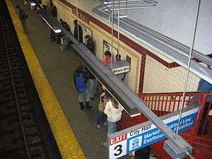
Philadelphia has the third oldest subway system in the United States, dating back to its opening in 1907.[18] Operated by the Philadelphia Rapid Transit Company until 1939[19] and the Philadelphia Transportation Company until 1968,[20] the SEPTA subway system consists of two rapid transit systems converging in Center City, and five surface level trolley lines operated in a shared subway through downtown Philadelphia.
Combined, the Market-Frankford Line and Broad Street Line have the sixth highest ridership of rapid transit systems in the United States, with a daily ridership of 316,253.[21] The rapid transit system has a total length of 25 miles (40 km) and 50 stations.[21] Feeder trolley and bus systems connect to the terminals of the Market-Frankford Line. At 69th Street Transportation Center, the Norristown High Speed Line, SEPTA Route 101, and SEPTA Route 102 connect to nearby suburbs, and a large bus depot handles SEPTA suburban bus routes. Near the eastern terminus of the Market-Frankford Line, three trackless trolley lines and multiple diesel bus lines converge. In addition, several regional rail lines stop at the Fern Rock Transportation Center of the Broad Street Line.
The Subway–Surface Trolley Lines are the remnants of an extensive pre-World War II streetcar system, similar to the Boston Green Line and San Francisco Muni Metro. The trolley lines were originally run by different companies, until their consolidation by the Philadelphia Rapid Transit Company in 1906.[22] The trolleys run in a tunnel from the Drexel University and University of Pennsylvania campuses to a loop around City Hall. Unlike light rail systems with articulated vehicles, the trolley lines use vehicles closer in size to classic PCC streetcars.
PATCO Speedline
The PATCO Speedline is a grade-separated system linking Philadelphia to the cities of Camden, Haddonfield, and Lindenwold in New Jersey. The Speedline has a daily ridership of 38,000,[23] and is the primary transit link between South Jersey and Philadelphia. It is operated by the Port Authority Transit Corporation, a subsidiary of the Delaware River Port Authority (DRPA), and is the only rail line in Philadelphia to operate 24 hours a day during the week. According to a study conducted by the Delaware Valley Regional Planning Commission, 95% of riders are New Jersey residents, and the Speedline carries 47% of New Jersey business commuters with jobs in Center City.[24]

SEPTA Route 15
Route 15, commonly known as the Girard Avenue Trolley, was restored in 2005 after having been operated with buses for 13 years. The 15 line runs along Girard Avenue through Greater Kensington, North Philadelphia, and West Philadelphia. The trolley utilizes restored PCC streetcars, a type of heritage trolley built in the 1930s. The trolleys were rebuilt with added air conditioning and regenerative braking.[25] Route 15 is the only active trolley line in Philadelphia that is not part of the Subway-Surface Trolley Line system.
SEPTA Regional Rail
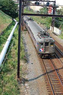
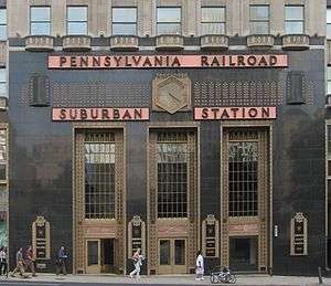
SEPTA's Regional Rail division consists of 13 lines with 153 active stations, totaling 280 miles (450 km) of trackage.[11] Each line is named by their station terminals, with the exception of the Manayunk/Norristown Line. The core of the Regional Rail system is the Center City Commuter Connection, a four-track tunnel under Center City linking three downtown stations: 30th Street Station, Suburban Station, and Jefferson Station. The Center City Commuter Connection was opened in 1984, built to connect the stub ends of the Pennsylvania Railroad and the Reading Railroad commuter rail systems. All SEPTA trains stop at the three downtown stations, with the exception of the Cynwyd Line (which terminates at Suburban Station).[26] Most trains stop at Temple University station, located on the eastern edge of the Temple University campus. Because the tunnel makes the through-routing of trains possible, most inbound trains from one line continue as outbound trains on another line.
Pennsylvania Railroad lines
| Line | Total Stations (After 30th Street) |
Terminal |
|---|---|---|
| Airport Line | 6 | Philadelphia International Airport |
| Wilmington/Newark Line | 18 | Marcus Hook, Claymont, Delaware, Wilmington, Delaware, or Newark, Delaware |
| Media/Elwyn Line | 15 | Media or Elwyn |
| Paoli/Thorndale Line | 22 | Bryn Mawr, Paoli, Malvern, or Thorndale |
| Cynwyd Line | 3 | Bala Cynwyd |
| Trenton Line | 11 | Trenton, New Jersey |
| Chestnut Hill West Line | 10 | Chestnut Hill (Philadelphia) |
Reading Company lines
| Line | Total Stations (After Temple University) |
Terminal |
|---|---|---|
| Warminster Line | 12 | Warminster |
| West Trenton Line | 18 | Ewing, New Jersey |
| Lansdale/Doylestown Line | 23 | Lansdale, Chalfont, or Doylestown |
| Manayunk/Norristown Line | 12 | Norristown |
| Chestnut Hill East Line | 10 | Chestnut Hill (Philadelphia) |
| Fox Chase Line | 6 | Fox Chase (Philadelphia) |
Atlantic City Line
New Jersey Transit operates the Atlantic City Line from 30th Street Station to Atlantic City, New Jersey. Historically run by the Pennsylvania-Reading Seashore Lines, the current line opened in 1989 by Amtrak as the "Gambler's Express" and has been operated solely by New Jersey Transit since 1996.[27] The line has six intermediate stops in New Jersey, with 13-16 departures in each direction per day.[28]
Intercity Rail

Intercity train service is operated out of 30th Street Station by Amtrak. Amtrak runs most services along the electrified Northeast Corridor, serving a densely urbanized string of cities in the northeastern United States. Amtrak runs at least 53 trains each weekday on its busiest route: Philadelphia to New York City.[29][30] Regular train service along the Northeast Corridor consists of the Acela Express, a high-speed train between Boston and Washington, and the Northeast Regional, a local service with northern terminals of either Boston, or Springfield, Massachusetts (using a diesel locomotive), and southern terminals of Washington, D.C., Newport News or Lynchburg, Virginia.[31] Amtrak runs several long-distance rail routes along the Northeast Corridor, including night trains. Long-distance trains run primarily on tracks owned and maintained by private freight railroads, and serve 39 states including the District of Columbia.[32]
Amtrak operates two routes along the Keystone Corridor, connecting Philadelphia to Harrisburg and Pittsburgh. The Keystone Corridor consists of two different segments: the section between Harrisburg and Philadelphia, and the segment west of Harrisburg to Pittsburgh. The eastern segment of the line, owned by Amtrak, is fully electrified and almost completely grade separated. The Philadelphia to Harrisburg section was upgraded to allow for top speeds of 110 miles per hour (180 km/h).[33] The section west of Harrisburg is a heavy-duty freight railroad owned by Norfork Southern. Regular service on the Keystone Corridor consists of the Keystone Service, which travels between Harrisburg and Philadelphia. After stopping in Philadelphia, certain trains continue along the Northeast Corridor to New York. The western section traverses mountainous terrain, and has obstacles limiting track speeds such as the Horseshoe Curve. The Pennsylvanian, consisting of one train in each direction per day, is the only route between Philadelphia and Pittsburgh.
Frequent service routes
| Train | Terminals | Frequency[29] | Stations | Route length | |
|---|---|---|---|---|---|
| Acela Express | Boston | Washington | 16 trains per weekday | 16 | 456 miles (734 km) |
| Keystone Service | New York | Harrisburg | 8-10 trains per weekday | 21 | 195 miles (314 km) |
| Philadelphia | Harrisburg | 3-5 trains per weekday | 12 | 104 miles (167 km) | |
| Northeast Regional | Boston | Washington | 17-21 trains per day | 30 | 456 miles (734 km) |
| Springfield | Washington | 1-2 trains per day | 28 | 364 miles (586 km) | |
Daily and nightly routes
| Train | Terminals | Frequency[30] | Stations | Route length | |
|---|---|---|---|---|---|
| Cardinal | New York | Chicago | 3 trains per week | 32 | 1,147 miles (1,846 km) |
| Carolinian | New York | Charlotte | Daily | 24 | 704 miles (1,133 km) |
| Crescent | New York | New Orleans | Daily | 33 | 1,377 miles (2,216 km) |
| Palmetto | New York | Savannah | Daily | 20 | 829 miles (1,334 km) |
| Pennsylvanian | New York | Pittsburgh | Daily | 19 | 444 miles (715 km) |
| Silver Meteor | New York | Miami | Daily | 32 | 1,389 miles (2,235 km) |
| Silver Star | New York | Miami | Daily | 36 | 1,522 miles (2,449 km) |
| Vermonter | St. Albans | Washington | Daily | 30 | 611 miles (983 km) |
Water transportation
Philadelphia Naval Shipyard
The former Philadelphia Naval Shipyard is located at the confluence of the Delaware and Schuylkill Rivers. The facility was used as a shipyard for the U.S. Navy until the cessation of military activities on September 27, 1996. The Naval Yard saw extensive use during World War II, when the yard employed a peak of 58,434 civilians and built 53 ships,[34][35] including the USS New Jersey and USS Wisconsin.
Aker Philadelphia Shipyard
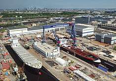
After the conversion of the Naval Yard for civilian uses, the Norwegian company Kværner rebuilt the western facility for commercial shipbuilding operations in partnership with the City of Philadelphia. Now called the Aker Philadelphia Shipyard, the yard opened in 2000 and delivered its first vessel in 2003.[36] The Aker Shipyard has built twelve ships, and has four vessels under construction.[37]
Port of Philadelphia
Since 1990, The Port of Philadelphia has been operated by the Philadelphia Regional Port Authority, a state agency created to fund the port infrastructure. The busiest facility of the Port of Philadelphia is the Packer Avenue Marine Terminal, located north of the Walt Whitman Bridge. The facility is serviced by three class-one railroads: CP Rail, CSX, and Norfolk Southern,[38] and is located in close proximity to I-95 and I-76. The Tioga Marine Terminal, located south of the Betsy Ross Bridge, has specialized equipment for handling Chilean fruit and Argentine juice.[39] The Port of Philadelphia is one of the Strategic Military Ports of the U.S. Department of Defense, making it one of only 14 ports in the United States permitted to handle the nation’s military cargo.[40]
Cruise Ship Terminal
The Delaware River Port Authority operates a cruise ship terminal at Pier One of the Philadelphia Naval Business Center.[41] No cruise lines are based at the terminal as of 2010, although two cruise lines have scheduled stops in Philadelphia.[42] The terminal handled a peak of 35 sailings in 2006,[43] when the Norwegian Majesty was based at the terminal before it was sold.[44]
RiverLink Ferry
The RiverLink Ferry is a passenger ferry that connects Penn's Landing with the Camden, NJ waterfront across the Delaware River. The ferry provides a way for tourists to reach waterfront attractions on both sides of the river, and it is managed by Hornblower Marine Services for the Delaware River Port Authority.[45]
Ride Sharing
Ride sharing mobile app Uber entered the Philadelphia market in June 2012 as a chauffeured limousine service.[46] UberX, which connects riders to drivers, began operating in Philadelphia in October 2014.[47]
Aviation
Philadelphia International Airport

Philadelphia International Airport (PHL) is the largest airport in the Philadelphia region and the 11th busiest airport in the world in 2008 in terms of traffic movements.[48] Most of PHL is located in Philadelphia proper, while the international terminal and the western end of the airfield are located in Tinicum Township.[49] Philadelphia International Airport is a domestic hub and the primary international hub of American Airlines. American Airlines uses Terminal A West, the international terminal, for flights to Europe and the Caribbean.[50] Terminals B and C are used exclusively for domestic American Airlines flights,[50] and American Eagle regional flights use Terminal F.[50] Southwest Airlines, a major domestic low-cost airline, began flights to PHL in 2004 despite its business model of utilizing secondary airports. Southwest Airlines operates its flights from Terminal E along with several other airlines.[50] UPS Airlines operates a regional freight hub at the airport.
PHL is connected to Center City by the SEPTA Airport Line, which has four stations throughout the airport and travels to 30th Street Station, Suburban Station, and Jefferson Station in downtown Philadelphia. The Airport Line costs $5.50 one way[51] for trips to downtown Philadelphia. Taxis charge a flat rate of $25 from the airport to downtown Philadelphia.[51]
Northeast Philadelphia Airport
Northeast Philadelphia Airport, located in the Ashton-Woodenbridge neighborhood of Northeast Philadelphia, is used for general aviation flights. It is the sixth busiest airport in Pennsylvania,[52] and has two runways. In 2006, the airport had an average of 289 aircraft operations per day, and 203 aircraft based at the airport.[53]
See also
References
- 1 2 3 4 Mihaly, Mark. Insiders' Guide to Philadelphia, 2007, p. 17.
- 1 2 Do other cities have logical street numbering systems like Chicago's?, Straight Dope Chicago, August 20, 2009.
- ↑ Crosstown Expressway, phillyroads.com.
- ↑ Cobbs Creek Expressway, phillyroads.com.
- ↑ Celebrating 80 Years, Delaware River Port Authority.
- 1 2 Walt Whitman Bridge, phillyroads.com.
- ↑ pprint of Aitken, Jane. A Statistical Account of the Schuylkill Permanent Bridge, Commenced September 5th 1801, Opened January 1st, 1805, 1807. (p.67)
- ↑ Study explores metro car ownership patterns, race, segregation and disaster planning, Regents of the University of California.
- ↑ Pressroom, Center City District / Central Philadelphia Development Corporation.
- ↑ First Map Paths, Schuylkill River Trail.
- 1 2 SEPTA Media Guide
- ↑ SEPTA Operating Facts, SEPTA. Accurate as of fiscal year 2009 (year ended 6/30/09). Archived November 18, 2008, at the Wayback Machine.
- ↑ Trolleybus Magazine No. 280 (July-Aug. 2008), p. 95.
- ↑ "Top Ten Busiest Terminals Based on Passenger Volume in 2008". Greyhound Lines, Inc.
- ↑ "Complimentary Bus Service Provided To/From JFK International Airport Terminal One." China Airlines. Retrieved on December 25, 2008.
- 1 2 Bus Routes in Other Counties, NJ TRANSIT. Accessed November 19, 2009.
- ↑ NJ Transit bus routes outside of New Jersey, NJ Transit.
- ↑ Jackson, Joseph. Market street, Philadelphia: the most historic highway in America, its merchants and its story, 1918, p. 201.
- ↑ Springirth, Kenneth C. Suburban Philadelphia Trolleys, 2007, p. 9.
- ↑ Springirth, Kenneth C. Suburban Philadelphia Trolleys, 2007, p. 73.
- 1 2 American Public Transportation Association, Public Transit Ridership Report, Third Quarter 2009.
- ↑ Springirth, Kenneth C. Southeastern Pennsylvania Trolleys, 2008, p. 91.
- ↑ "Card makes change for PATCO riders" by Eileen Stilwell, Courier-Post, July 11, 2006, retrieved July 11, 2006
- ↑ PATCO History, Delaware River Port Authority.
- ↑ "Philadelphia's PCCs Return to Service." Railway Age. Vol. 205, No. 10, p. 30. October 1, 2005.
- ↑ SEPTA Regional Rail, world.nycsubway.org.
- ↑ Atlantic City Line, world.nycsubway.org.
- ↑ Atlantic City Line Master File, NJ Transit. Updated November 8, 2009.
- 1 2 Northeast Corridor Timetable, Amtrak, effective January 18, 2010.
- 1 2 Amtrak System Timetable, Amtrak, Fall 2009/Winter 2010.
- ↑ Amtrak - Northeast Regional
- ↑ Amtrak: Long Distance Trains: FY 2008
- ↑ Q&A with Amtrak President Alex Kummant, Reuters.
- ↑ The Society. History of civil engineering and construction in the Delaware Valley, 1976, p. 157.
- ↑ Dorwart, Jeffery M. and Wolf, Jean K. The Philadelphia Navy Yard: from the birth of the U.S. Navy to the nuclear age, 2001, p. 179-180.
- ↑ History, Aker Philadelphia Shipyard Inc.
- ↑ Aker Philadelphia Shipyard Delivers Eighth Product Tanker, Aker Philadelphia Shipyard Inc, December 12, 2009.
- ↑ Packer Avenue Marine Terminal, Philadelphia Regional Port Authority.
- ↑ Tioga Marine Terminal, Delaware River Stevedores, Inc.
- ↑ PRPA: History, Philadelphia Regional Port Authority.
- ↑ Philadelphia Cruise Port and Terminal, Philadelphia Cruise Guide.
- ↑ Loyd, Linda. Philly has hopes to regain lost cruise business, The Philadelphia Inquirer, Dec. 23, 2009. "The Delaware River Port Authority's 2010 budget shows no cruises are booked at the Philadelphia Cruise Terminal at the Navy Yard, although two cruise lineswill have port calls here next year."
- ↑ Loyd, Linda. Philly has hopes to regain lost cruise business, The Philadelphia Inquirer, Dec. 23, 2009. "The cruise business has tailed off from a peak of 35 sailings in 2006 and 32 in 2005 to only eight this year."
- ↑ Loyd, Linda. Philly has hopes to regain lost cruise business, The Philadelphia Inquirer, Dec. 23, 2009. "In 2008, Norwegian Cruise Line's Majesty made Philadelphia its home, offering 10 sailings that year and eight in 2009. But the Majesty was recently sold."
- ↑ "New Delaware River ferry tours set to begin", Philadelphia Business Journal, May 31, 2005
- ↑ "Uber Launches in Philly TODAY, Though We Have No Idea Why". Curbed Philly. Retrieved 2016-01-13.
- ↑ "UberX marks a year operating illegally in Philadelphia". philly-archives. Retrieved 2016-01-13.
- ↑ Traffic Movements 2008 Final from Airports Council International
- ↑ Airport authority bill draws support, ire, Delaware County Daily Times, January 14, 2010.
- 1 2 3 4 PHL Map, Philadelphia International Airport.
- 1 2 Taxis & Trains, PHL.org.
- ↑ Philadelphia Airport System. "Philadelphia Northeast Airport". City of Philadelphia.
- ↑ FAA Airport Master Record for PNE (Form 5010 PDF), effective 2008-06-05
External links
| Wikimedia Commons has media related to Transport in Philadelphia. |