Oklahoma State Highway 99
| |||||||
|---|---|---|---|---|---|---|---|
 | |||||||
| Route information | |||||||
| Maintained by ODOT | |||||||
| Length: | 241.5 mi[1] (388.7 km) | ||||||
| Existed: |
(as SH-48) January 19, 1927–May 16, 1938[2] (as SH-99) May 17, 1938[3] – present | ||||||
| Major junctions | |||||||
| South end: |
| ||||||
| North end: |
| ||||||
| Highway system | |||||||
| |||||||

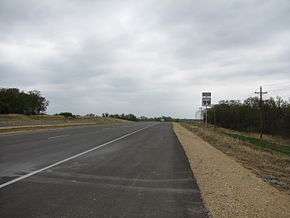
State Highway 99, abbreviated SH-99, is a north–south state highway through central Oklahoma. It runs from the Texas border at Lake Texoma to the Kansas border near Lake Hulah. It is 241.5 miles (388.7 km) long. The highway overlaps US-377 for over half its length.
SH-99 links up with K-99 after crossing the border into Kansas. This road continues for 233 miles (375 km) to the Nebraska border, where it becomes Nebraska Highway 99, which lasts an additional 14 miles (23 km). Thus, SH-99 is part of a triple-state highway numbered "99", which lasts a total of 488 miles (785 km).
State Highway 99 began as State Highway 48, a short highway connecting Ada to Holdenville. This highway was gradually expanded until it became a border-to-border route. In 1938, it was renumbered to match K-99, which was renumbered from K-11 the same day.
Route description
US-377/SH-99
US-377 crosses Lake Texoma on a bridge from Grayson County, Texas into Marshall County, Oklahoma. This is the southern terminus of SH-99, which will concur with US-377 all the way to the U.S. highway's northern terminus in Stroud, a distance of 139.91 miles (225.16 km).[4] The highways' first junction in Oklahoma is with State Highway 32 7 miles (11 km) south of Madill. Five miles north of this intersection, US-377/SH-99 serve as the northern terminus for SH-99C, a child route of SH-99. The routes then head into Madill, where they form a brief concurrency with US-70 and SH-199. US-377/SH-99 head northeast out of town and enter Johnston County.[5]
West of Tishomingo, US-377/SH-99 pick up SH-22, which follows them east to the county seat. The same junction in Tishomingo where SH-22 splits away is also the northern terminus of SH-78. Eight miles (12.9 km) north of Tishomingo, the routes share a short concurrency with SH-7. US-377/SH-99 go 18 miles (29 km) without another highway junction, which is with SH-99A, a spur to unincorporated Harden City.[5]
The two highways interchange with SH-3, a freeway at this point, near Ahloso. US-377/SH-99 merge onto the freeway, which becomes the Richardson Loop around the west side of Ada. At the southwest corner of the loop, SH-1 joins. Two miles (3.2 km) further north, an interchange serves as the western terminus of SH-19; also at this interchange, SH-3 splits into SH-3E and SH-3W, the latter of which exits the highway to concur with SH-19. At the next interchange, SH-1 splits off, and the freeway downgrades to expressway.[5]
The highway crosses the Canadian River into Seminole County north of Byng. Just after the bridge, US-377/SH-3E/99 intersect SH-39 and SH-56; this is their eastern and western termini respectively. Near Bowlegs, SH-59 joins the concurrency, splitting off again after 3 miles (4.8 km). As the road enters Seminole, it has an interchange with US-270, where SH-3E splits off. SH-9 also is accessible by interchange in Seminole. US-377/SH-99 encounter another spur of the latter, SH-99A, in unincorporated Little. The routes then have an interchange at I-40, Exit 200.[5]
US-377/SH-99 cross over the North Canadian River and cross a panhandle of Pottawatomie County before entering Lincoln County. Just north of the county line, the routes pass through Prague. The two routes do not encounter another highway for 19 miles (31 km), after which lies the town of Stroud, the northern terminus of US-377.
Stroud and the end of US-377
In Stroud, SH-99 has two highway junctions, one of which is the northern terminus of US-377. In central Stroud, the highway meets SH-66, formerly the celebrated Route 66. An interchange with Interstate 44, the Turner Turnpike, is 0.4 miles (0.64 km) north of the SH-66 junction.[1]
Signage in Stroud is unclear on where the northern terminus of US-377 is, implying that it continues north of SH-66 to at least I-44. ODOT sources differ on where the northern terminus of the highway is. According to the Control Section Map Book, the north end of US-377 is at SH-66.[6] Another map published by ODOT of Stroud implies that the route extends north of the ramps to and from I-44 to at least the bridge over the turnpike.[7] The US-377 highway log shows US-377 ending at I-44.[4] The inset strip map of the Turner Turnpike on the ODOT state map omits US-377 entirely.[5]
North of Stroud
Seventeen miles north of Stroud, the now-independent SH-99 meets State Highway 33, which it overlaps for two miles (3 km) to the town of Drumright. SH-99 bypasses Drumright to the northwest, after which it meets up with an old alignment leading back to Drumright and SH-33, now numbered SH-99B but unsigned.[8] After turning back north, it crosses the Cimarron River at Oilton, and has an interchange with the Cimarron Turnpike between Jennings and Hallett.
It is then concurrent with US-64 for six miles (10 km) before passing through Cleveland, where it crosses the Arkansas River. Throughout its final 55 miles (89 km), in Osage County, the highway passes through a relatively sparse region, though it meets State Highway 20 in Hominy and overlaps SH-11 south of Pawhuska (the county seat) and US-60 north of the city. Its final junction is with SH-10 ten miles (16 km) south of the Oklahoma–Kansas border.
History
The original SH-48

State Highway 99 traces its roots back to the first State Highway 48, which was first established on January 19, 1927.[2] This highway connected Ada to Holdenville; it roughly followed present-day SH-99 until about 2 miles north of the Canadian River, it then turned east and passed 1 mile south of the unincorporated town of Vamoosa, after which it followed the route of today's SH-56. After 10 miles, it passed through Sasakwa, in which it turned north and ended at the original SH-3, at the intersection called "Five-Mile Corner", west of Holdenville.[9] The 1928 state highway map shows the highway extended to SH-9 (now US-62) near Prague along the present-day SH-99 alignment, with the Canadian River crossing as a toll bridge.[10] By January 1, 1929, the route had been realigned to pass through Konawa.[11] The old designation between the Canadian River and SH-3 was replaced shortly after by SH-56.
In 1931, SH-48 was greatly expanded. The route was extended northward to US-66 in Stroud.[12] At its southern end, it was extended along a new alignment, which began at SH-19, present day SH-3, southeast of Ada and ran through Tishomingo and Madill to end at the Red River northwest of Denison, Texas, where it met Texas State Highway 91. Also that year, a second section of SH-48 was established, taking over a large portion of what was then SH-25; the remainder of the route was integrated into US-60.[12]
On March 1, 1932, a new section of road was designated as State Highway 48, connecting Stroud to SH-33 west of Drumright.[2] As a result, the SH-48 designation was able to follow existing roads to link up with its previously-disconnected northern section. Thus, SH-48 became a border-to-border highway, linking Texas and its SH-91 to K-11 at the Kansas state line.[13]
Renumbering and realignments
On May 17, 1938, both Kansas and Oklahoma renumbered K-11 and OK-48 respectively to bear the number "99", providing continuity between the states.[3] At this time, SH-99 followed the same basic corridor of the present-day route from Madill north to Kansas. However, SH-48's designation was still in use from May 1938 to February 1941. The SH-48 designation was then made into the route passing through Konawa, which the SH-99 designation bypassed. After SH-48 was discontinued, however, it would only remain discussed for just under three years, SH-48 resurfacing for a route only 13 miles (21 km) east of SH-99.[2] The portion of SH-48 from SH-99 to Konawa would later become part of SH-39.
In January 1944, Denison Dam was placed into operation, creating Lake Texoma. As a result, a portion of SH-99 between Madill and Texas was inundated.[14] On May 5, 1958, the route was realigned to once again reach Texas;[3] it now crossed a bridge further upstream, connecting to Texas State Highway 10,[15] which was subsequently renumbered to TX-99.[16]
The existing route of SH-99 (concurrent with SH-3) veered west by about 4 miles (6.4 km) to once again serve the town of Konawa before cutting back northeast to continue the highway's previous heading.[5][17] This was remedied on December 9, 1968, when the highway was changed to a straighter alignment bypassing Konawa. The old road heading west into Konawa became part of SH-39.[3]
Another bypass occurred in 1977, this time in Drumright. SH-99 was changed to bypass the town on February 7, 1977, and the old alignment that was not part of SH-33 became SH-99B.[3]
Designation as US-377
The Oklahoma Department of Highways had proposed portions of State Highway 99 for inclusion in the United States Numbered Highways system several times. One such application made in 1953 suggested that the entirety of SH-99 become a U.S. Route, while another suggested a northern terminus at US-64 near Cleveland. On June 18, 1964, AASHTO accepted an extension of US-377 from Texas to US-70 in Madill. The Department of Highways, and later the Department of Transportation, submitted an application to extend US-377 from Madill to US-64 in Cleveland eight times between December 1964 and 1980.[18]
In 1991, ODOT signed the route to Stroud along SH-99 without AASHTO approval.[19]
Spurs
SH-99 has two lettered spurs:
- SH-99A is a designation for two distinct highways:
- A connector highway from US-377/SH-99 to the unincorporated town of Harden City. It was originally known as SH-61A .
- A highway that runs from west of Little to SH-3E, east to SH-48 near Bearden.
- SH-99B has one previous and one present highway
- A 1.09 miles (1.75 km)-long highway in Drumright, connecting SH-33 north to SH-99, forming the east edge of a loop around town.[8] It is a former alignment of SH-99.
- Former route commissioned in 1948 connecting Bowlegs to Wewoka. It was renumbered to SH-59 in 1965 to extend SH-59 from its former terminus 3 miles north of Bowlegs
- SH-99C connects US-377/SH-99 in Madill to SH-32 near Lake Texoma.
- SH-99D was a loop north of Hominy, Oklahoma serving the nearby state prison, Connors Correctional Center. The loop was decommissioned in the 1990s, and the bridge over Bird Creek is no longer passable .
Junction list
| County | Location | mi[1] | km | Destinations | Notes | |||
|---|---|---|---|---|---|---|---|---|
| Lake Texoma (Red River) | 0.0 | 0.0 | ||||||
| Marshall | | 9.2 | 14.8 | |||||
| | 14.2 | 22.9 | Northern terminus of SH-99C | |||||
| Madill | 16.0 | 25.7 | Southern terminus of US-70 concurrency | |||||
| 16.5 | 26.6 | Northern terminus of US-70 concurrency, southern terminus of SH-199 concurrency | ||||||
| Northern terminus of SH-199 concurrency | ||||||||
| Johnston | Tishomingo | 29.1 | 46.8 | Southern terminus of SH-22 concurrency | ||||
| 30.2 | 48.6 | Northern terminus of SH-22 concurrency | ||||||
| | 38.8 | 62.4 | Southern terminus of SH-7 concurrency | |||||
| | 39.7 | 63.9 | Northern terminus of SH-7 concurrency | |||||
| Pontotoc | | 57.4 | 92.4 | Western terminus of SH-99A | ||||
| Ahloso | 65.6 | 105.6 | Interchange, south end of SH-3 overlap | |||||
| Ada | Stonecipher Boulevard | Interchange | ||||||
| 67.6 | 108.8 | Interchange, northbound exit and southbound entrance, northern terminus of SH-3 concurrency | ||||||
| 70.2 | 113.0 | Southern terminus of SH-1 concurrency | ||||||
| 72.2 | 116.2 | interchange, northern terminus of SH-1 concurrency, southern terminus of SH-3E concurrency | ||||||
| Seminole | | 82.8 | 133.3 | Western terminus of SH-56, eastern terminus of SH-39 | ||||
| Bowlegs | 97.2 | 156.4 | Southern terminus of SH-59 concurrency | |||||
| | 99.9 | 160.8 | Northern terminus of SH-59 concurrency | |||||
| Seminole | 102.3 | 164.6 | Northern terminus of SH-3E concurrency | |||||
| 103.9 | 167.2 | |||||||
| Little | 110.9 | 178.5 | ||||||
| | 113.4 | 182.5 | Interchange, I-40 exit 200 | |||||
| Pottawatomie |
No major junctions | |||||||
| Lincoln | Prague | 120.9 | 194.6 | |||||
| Stroud | 139.5 | 224.5 | Possible northern terminus of US-377 | |||||
| 139.9 | 225.1 | Possible northern terminus of US-377 | ||||||
| Payne | | 156.0 | 251.1 | Southern terminus of SH-33 concurrency | ||||
| Creek | Drumright | 158.1 | 254.4 | Northern terminus of SH-33 concurrency, southern terminus of SH-33 Truck concurrency | ||||
| 160.4 | 258.1 | Northern terminus of SH-33 Truck concurrency | ||||||
| | 168.6 | 271.3 | ||||||
| Pawnee | | 175.7 | 282.8 | Cimarron Turnpike exit 48 | ||||
| | 180.3 | 290.2 | Southern terminus of US-64 concurrency | |||||
| Cleveland | 186.5 | 300.1 | Northern terminus of US-64 concurrency | |||||
| Osage | Hominy | 196.3 | 315.9 | |||||
| | 210.0 | 338.0 | Southern terminus of SH-11 concurrency | |||||
| Pawhuska | 215.3 | 346.5 | Northern terminus of SH-11 concurrency, southern terminus of US-60 concurrency | |||||
| | 220.8 | 355.3 | Northern terminus of US-60 concurrency | |||||
| | 231.2 | 372.1 | Western terminus of SH-10 | |||||
| Oklahoma–Kansas state line | 240.9 | 387.7 | ||||||
1.000 mi = 1.609 km; 1.000 km = 0.621 mi
| ||||||||
References
- 1 2 3 Google (January 7, 2013). "Oklahoma State Highway 99" (Map). Google Maps. Google. Retrieved January 7, 2013.
Google (January 8, 2013). "Oklahoma State Highway 99" (Map). Google Maps. Google. Retrieved January 8, 2013. - 1 2 3 4 Oklahoma Department of Transportation. "Memorial Dedication and Revision History, SH 48". Retrieved 2009-12-22.
- 1 2 3 4 5 Oklahoma Department of Transportation. "Memorial Dedication and Revision History, SH 99". Retrieved 2009-12-22.
- 1 2 Oklahoma Department of Transportation. "State Highway System: Log of U.S. Highway 377" (PDF). Retrieved January 7, 2013.
- 1 2 3 4 5 6 Official State Map (PDF) (Map) (2008 ed.). Oklahoma Department of Transportation. Retrieved 2009-12-23.
- ↑ 2008 Control Section Maps (PDF) (Map). Oklahoma Department of Transportation. p. Lincoln 41. Retrieved 2009-12-23.
- ↑ City of Stroud (PDF) (Map). Oklahoma Department of Transportation. Retrieved 2009-12-24.
- 1 2 2008 Control Section Maps (PDF) (Map). Oklahoma Department of Transportation. p. Creek 19. Retrieved 2009-12-23.
- ↑ Oklahoma State Highway System (PDF) (Map) (1927 ed.). Oklahoma State Highway Department. Retrieved 2009-12-23.
- ↑ Oklahoma State Highway System (PDF) (Map) (1928 ed.). Oklahoma State Highway Department. Retrieved 2009-12-23.
- ↑ Map Showing Condition of Improvement of the State Highway System (PDF) (Map) (January 1, 1929 ed.). Oklahoma State Highway Department. Retrieved 2009-12-23.
- 1 2 Map Showing Condition of Improvement of the State Highway System (PDF) (Map) (December 31, 1931 ed.). Oklahoma State Highway Department. Retrieved 2009-12-23.
- ↑ Map Showing Condition of Improvement of the State Highway System (PDF) (Map) (June 1932 ed.). Oklahoma Department of Highways. Retrieved 2009-12-23.
- ↑ Map Showing Condition of Improvement of the State Highway System (PDF) (Map) (June 1944 ed.). Oklahoma Department of Highways. Retrieved 2009-12-23.
- ↑ Oklahoma 1961 Road Map (PDF) (Map). Oklahoma Department of Highways. Retrieved 2009-12-23.
- ↑ Oklahoma-1964 (PDF) (Map). Oklahoma Department of Highways. Retrieved 2009-12-23.
- ↑ Map Showing Condition of the State Highway System (PDF) (Map) (April 1939 ed.). Oklahoma Department of Highways.
- ↑ Oklahoma Department of Transportation. "Memorial Dedication and Revision History, US 377". Retrieved 2009-12-23.
- ↑ Sanderson, Dale. "End of US-377". USEnds. Retrieved 2009-12-23.