Umpqua River Bridge
| Umpqua River Bridge | |
|---|---|
 | |
| Carries |
|
| Crosses | Umpqua River |
| Locale | Reedsport, Oregon |
| Characteristics | |
| Design | Swing bridge |
| Material | Steel |
| History | |
| Designer | Conde B. McCullough |
| Construction begin | 1934 |
| Opened |
1936 |
|
Umpqua River Bridge No. 01822 | |
|
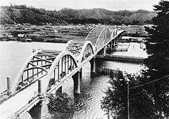
The bridge in 1939 | |
| Location | Reedsport, Oregon |
| Built | 1934–1936 |
| MPS | McCullough, C.B., Major Oregon Coast Highway Bridges, 1927–1936 |
| NRHP Reference # | 05000815[1] |
| Added to NRHP | August 5, 2005[1] |
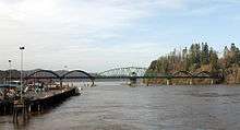
The Umpqua River Bridge is a swing-span bridge that spans the Umpqua River in Reedsport, Oregon. It consists of a central swing span flanked by two reinforced concrete arches on each end. The swing span was necessary to accommodate tall sailing vessels which were common on the Umpqua River. The final cost of the bridge was $510,500.
Located at milepoint 211.11 on U.S. Route 101, this bridge is the only remaining swing-span bridge on the Oregon state highway system.[2] This bridge was one of the many bridge projects of Conde McCullough, Oregon's Master Bridge Designer and Builder.[2] It opened to traffic on July 3, 1936.[3]
The north end of the bridge is within Bolon Island Tideways State Scenic Corridor; the south is within Reedsport city limits. The bridge was added to the National Register of Historic Places on August 5, 2005.[1]
No dedication ceremony occurred at the time due to the unavailability of President Franklin Roosevelt. The ceremony was postponed indefinitely. At 3pm on September 8, 2011, the bridge was opened and closed, followed by a ribbon cutting, and cars from the 1910s, 1920s and 1930s crossed the bridge. It was finally officially dedicated to celebrate its 75th anniversary.
Gallery
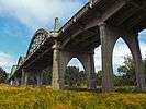
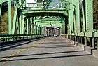 Umpqua River Bridge seen towards north
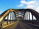
See also
-
 Bridges portal
 -
 Oregon portal
 - List of bridges on U.S. Route 101 in Oregon
- List of bridges on the National Register of Historic Places in Oregon
References
- 1 2 3 "Oregon National Register List" (PDF). Oregon Parks and Recreation Department. June 6, 2011. p. 10. Retrieved June 7, 2013.
- 1 2 Spanning Oregon's Coast: Oregon has more than 200 historic bridges Brochure. Oregon Department of Transportation. Retrieved May 24, 2013.
- ↑ "Span at Newport Open For Traffic [Yaquina Bay Bridge]" (September 6, 1936). The Sunday Oregonian (Portland), pp. 1–2.
- Hadlow, Robert W. (2001). Elegant Arches, Soaring Spans: C.B. McCullough, Oregon's Master Bridge Builder. Corvallis, OR: Oregon State University Press. ISBN 0-87071-534-8.
- Oberrecht, Kenneth. (2001). Oregon Coastal Access Guide: A Mile-by-Mile Guide to Scenic and Recreational Attractions. Corvallis, OR: Oregon State University Press. ISBN 0-87071-491-0.
External links
| Wikimedia Commons has media related to Umpqua River Bridge. |
- Umpqua River Bridge, Spanning Umpqua River at Oregon Coast Highway, Reedsport, Klamath, OR at the Historic American Engineering Record (HAER)
- Video of bridge's swing span opening on YouTube
Coordinates: 43°42′36″N 124°06′03″W / 43.709883°N 124.100728°W
| Lists by county |  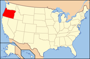 | |
|---|---|---|
| Portland lists | ||
| Other lists |
| |