National Register of Historic Places listings in Columbia County, Oregon
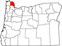
Location of Columbia County in Oregon
This list presents the full set of buildings, structures, objects, sites, or districts designated on the National Register of Historic Places in Columbia County, Oregon, and offers brief descriptive information about each of them. The National Register recognizes places of national, state, or local historic significance across the United States.[1] Out of over 90,000 National Register sites nationwide,[2] Oregon is home to over 2,000,[3] and 12 of those are found partially or wholly in Columbia County.
- This National Park Service list is complete through NPS recent listings posted December 2, 2016.[4]
Current listings
| [5] | Name on the Register | Image | Date listed[6] | Location | City or town | Description |
|---|---|---|---|---|---|---|
| 1 | Dr. Charles G. and Lucinda McBride Caples Farmstead | 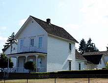 |
(#05001060) |
1925 1st Street 45°53′25″N 122°48′28″W / 45.89032°N 122.8077°W |
Columbia City | |
| 2 | Clatskanie IOOF Hall | 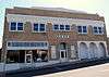 |
(#12000078) |
75 S. Nehalem Street 46°06′13″N 123°12′14″W / 46.10363333°N 123.2039611°W |
Clatskanie | |
| 3 | Cox–Williams House | 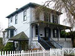 |
(#82001501) |
280 S 1st Street 45°51′45″N 122°47′51″W / 45.862593°N 122.797522°W |
St. Helens | |
| 4 | Thomas J. Flippin House |  |
(#79002048) |
620 Tichenor Street 46°06′03″N 123°12′28″W / 46.10074°N 123.2077°W |
Clatskanie | |
| 5 | John and Carolena Heimuller Farmstead |  |
(#11000049) |
32600 SW J. P. West Road 45°45′18″N 122°53′48″W / 45.754937°N 122.896690°W |
Scappoose vicinity | |
| 6 | Longview Bridge | |
(#82004208) |
On Washington Highway 433 spanning the Columbia River 46°05′58″N 122°58′00″W / 46.09934°N 122.9667°W |
Rainier | |
| 7 | George F. Moeck House |  |
(#78002283) |
713 B Street, W. 46°05′28″N 122°56′42″W / 46.09115°N 122.9451°W |
Rainier | |
| 8 | Oregon–American Lumber Company Mill Office | 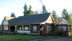 |
(#02001485) |
511 E Bridge Street 45°51′27″N 123°10′52″W / 45.85759°N 123.1811°W |
Vernonia | |
| 9 | Portland and Southwestern Railroad Tunnel |  |
(#81000481) |
Along the Scappoose–Vernonia Highway; details of the specific location are restricted.[7] |
Scappoose vicinity | The Portland and Southwestern Railroad's 1910–1920 construction of this timber-lined tunnel across the Nehalem Divide was an unusual step for a logging railroad, which would typically rely on less permanent infrastructure. The tunnel and rail line were abandoned in 1945 as the timber industry transitioned to log transport by truck.[7] |
| 10 | St. Helens Downtown Historic District | 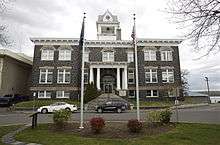 |
(#84000137) |
Roughly Strand, 1st, 2nd, 3rd, Cowlitz, and St. Helens Streets, and Columbia Boulevard 45°51′50″N 122°47′56″W / 45.86388°N 122.799°W |
St. Helens | |
| 11 | James Grant Watts House |  |
(#80003308) |
206 SE 1st Street 45°45′22″N 122°52′36″W / 45.75618°N 122.8767°W |
Scappoose | |
| 12 | Woodbine Cemetery – Green Mountain Cemetery |  |
(#01000829) |
75900 Larson Road 46°05′56″N 122°59′52″W / 46.09894°N 122.9977°W |
Rainier vicinity |
See also
- National Register of Historic Places listings in Oregon
- Listings in neighboring counties: Clark, Clatsop, Cowlitz, Multnomah, Tillamook, Wahkiakum, Washington
- Historic preservation
- History of Oregon
- Lists of Oregon-related topics
References
- ↑ Andrus, Patrick W.; Shrimpton, Rebecca H.; et al. (2002), How to Apply the National Register Criteria for Evaluation, National Register Bulletin (15), National Park Service, U.S. Department of the Interior, OCLC 39493977, archived from the original on April 6, 2014, retrieved June 20, 2014.
- ↑ National Park Service, National Register of Historic Places Program: Research, archived from the original on February 1, 2015, retrieved January 28, 2015.
- ↑ Oregon Parks and Recreation Department, Oregon Historic Sites Database, retrieved August 6, 2015. Note that a simple count of National Register records in this database returns a slightly higher total than actual listings, due to duplicate records. A close reading of detailed query results is necessary to arrive at the precise count.
- ↑ "National Register of Historic Places: Weekly List Actions". National Park Service, United States Department of the Interior. Retrieved on December 2, 2016.
- ↑ Numbers represent an ordering by significant words. Various colorings, defined here, differentiate National Historic Landmarks and historic districts from other NRHP buildings, structures, sites or objects.
- ↑ The eight-digit number below each date is the number assigned to each location in the National Register Information System database, which can be viewed by clicking the number.
- 1 2 McCamish, Brian (June 30, 2006). "Portland & Southwestern Railroad and the Nehalem Divide Tunnel". In Search of History Expeditions. Gresham, Oregon. Retrieved April 3, 2009.
External links
- Oregon Parks and Recreation Department, National Register Program
- National Park Service, National Register of Historic Places site
 Media related to National Register of Historic Places in Columbia County, Oregon at Wikimedia Commons
| Lists by county |  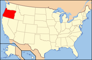 | |
|---|---|---|
| Portland lists | ||
| Other lists |
| |
| Topics | |
|---|---|
| Lists by states |
|
| Lists by insular areas | |
| Lists by associated states | |
| Other areas | |
| |
Municipalities and communities of Columbia County, Oregon, United States | ||
|---|---|---|
| Cities | | |
| CDPs | ||
| Other unincorporated communities | ||
This article is issued from Wikipedia - version of the 8/30/2016. The text is available under the Creative Commons Attribution/Share Alike but additional terms may apply for the media files.