Union Downtown Historic District
|
Union Downtown Historic District | |
|
Union Depot, Union Downtown Historic District, March 2012 | |
  | |
| Location | Roughly bounded by E. Academy, N. Church, Main, and N. Herndon Sts., Sharpe Ave., and N. Gadberry St., Union, South Carolina |
|---|---|
| Coordinates | 34°42′55″N 81°37′23″W / 34.71528°N 81.62306°WCoordinates: 34°42′55″N 81°37′23″W / 34.71528°N 81.62306°W |
| Area | 110.1 acres (44.6 ha) |
| Architectural style | Late 19th And Early 20th Century American Movements |
| MPS | Union MPS |
| NRHP Reference # | 89000795, 03000206 (Boundary Increase)[1] |
| Added to NRHP | July 17, 1989, April 11, 2003 (Boundary Increase) |
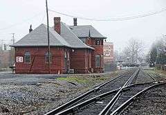
Union Downtown Historic District is a national historic district located at Union, Union County, South Carolina. The district encompasses 48 contributing buildings in the central business district of Union. The commercial, public, residential, industrial, and transportation-related buildings were built between about 1878 to about 1940, with the majority dating from about 1880 to about 1930. The district includes buildings representative of the Neo-Classical and Victorian styles. Notable buildings include the Union County Courthouse, Union Post Office/Federal Building, Flynn Building, Krass Building, People's State Bank/Arthur State Bank, Union Depot, Union Cotton Oil Mill, and Union Hardware Co. Located in the district is the separately listed Fair Forest Hotel.[2][3][4]
It was added to the National Register of Historic Places in 1989, with a boundary increase in 2003.[1]
References
- 1 2 National Park Service (2010-07-09). "National Register Information System". National Register of Historic Places. National Park Service.
- ↑ J. Tracy Power and John W. Shaw (July 1988). "Union Downtown Historic District" (pdf). National Register of Historic Places - Nomination and Inventory. Retrieved 2014-07-01.
- ↑ "Union Downtown Historic District, Union County (Union)". National Register Properties in South Carolina. South Carolina Department of Archives and History. Retrieved 2014-07-01. and accompanying map
- ↑ Paul Gettys (July 2002). "Union Downtown Historic District (Boundary Increase)" (pdf). National Register of Historic Places - Nomination and Inventory. Retrieved 2014-07-01.
| Topics |   | |
|---|---|---|
| Lists by county |
| |
| Lists by city | ||
| Other lists | ||