Union Hill, Minnesota
| Union Hill, Minnesota | |
|---|---|
| Unincorporated community | |
 Union Hill, Minnesota  Union Hill, Minnesota Location of the community of Union Hill | |
| Coordinates: 44°32′37″N 93°40′02″W / 44.54361°N 93.66722°WCoordinates: 44°32′37″N 93°40′02″W / 44.54361°N 93.66722°W | |
| Country | United States |
| State | Minnesota |
| County | Le Sueur and Scott |
| Township | Derrynane Township and Belle Plaine Township |
| Elevation | 994 ft (303 m) |
| Time zone | Central (CST) (UTC-6) |
| • Summer (DST) | CDT (UTC-5) |
| ZIP code | 56071 |
| Area code(s) | 952 |
| GNIS feature ID | 653506[1] |
Union Hill is an unincorporated community in Le Sueur and Scott counties in the U.S. state of Minnesota.
The community is located four miles west of New Prague at the junction of State Highway 19 (MN 19), County Road 31 (201st Avenue), and Church Avenue. Nearby places also include Heidelberg, Henderson, and Belle Plaine. The West Branch of Raven Stream flows through the community.
Union Hill is located within Derrynane Township in Le Sueur County; and also located within Belle Plaine Township in Scott County. A post office previously operated in the community from 1876 to 1903. Union Hill is located within ZIP code 56071 based in New Prague.
The community is present primarily due to the 1867 founding of St. John the Evangelist (Roman Catholic) Church.
References
- Source: Rand McNally Road Atlas – 2007 edition – Minnesota entry
- Source: Official State of Minnesota Highway Map – 2013/2014 edition
- The Early Settlers of St. John's Parish at Union Hill in 1867
Municipalities and communities of Le Sueur County, Minnesota, United States | ||
|---|---|---|
| Cities | 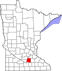 | |
| Townships | ||
| Unincorporated communities | ||
| Footnotes | ‡This populated place also has portions in an adjacent county or counties | |
Municipalities and communities of Scott County, Minnesota, United States | ||
|---|---|---|
| Cities | 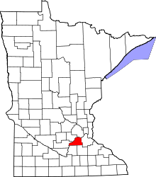 | |
| Townships | ||
| Unincorporated communities | ||
| Ghost towns | ||
| Indian reservation | ||
| Footnotes | ‡This populated place also has portions in an adjacent county or counties | |