Cleveland, Minnesota
| Cleveland, Minnesota | |
|---|---|
| City | |
| Motto: "Friendly People, Our Greatest Asset"[1] | |
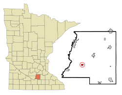 Location of Cleveland, Minnesota | |
| Coordinates: 44°19′22″N 93°50′18″W / 44.32278°N 93.83833°W | |
| Country | United States |
| State | Minnesota |
| County | Le Sueur |
| Government | |
| • Type | Mayor - Council |
| • Mayor | Richard Walter |
| Area[2] | |
| • Total | 0.60 sq mi (1.55 km2) |
| • Land | 0.60 sq mi (1.55 km2) |
| • Water | 0 sq mi (0 km2) |
| Elevation | 1,033 ft (315 m) |
| Population (2010)[3] | |
| • Total | 719 |
| • Estimate (2012[4]) | 713 |
| • Density | 1,198.3/sq mi (462.7/km2) |
| Time zone | Central (CST) (UTC-6) |
| • Summer (DST) | CDT (UTC-5) |
| ZIP code | 56017 |
| Area code(s) | 507 |
| FIPS code | 27-11872[5] |
| GNIS feature ID | 0641329[6] |
| Website | http://www.clevelandmn.govoffice2.com/ |
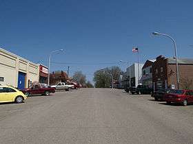
Cleveland is a city in Le Sueur County, Minnesota, United States. The population was 719 at the 2010 census.[7]
History
Cleveland was established as a village in 1854, and incorporated as a city in 1904.[1] The community was named after Cleveland, Ohio.[8]
Under its original founders, Cleveland was a temperance town and thus voted no licensing of saloons in the town. [9]
Following the year 1858, Cleveland and, nearby settlement, Le Sueur began a heated rivalry over the role of the Le Sueur county seat. The rivalry continued with only minor bloodshed until 1875, when a group of Cleveland citizens organized a militia to take the county seat by force. The militia successfully retrieved the county seat from Le Sueur. After more than year of holding the county seat, Le Center was agreed to take the seat where it is still held to this date. [10]
Geography
According to the United States Census Bureau, the city has a total area of 0.60 square miles (1.55 km2), all of it land.[2]
Demographics
| Historical population | |||
|---|---|---|---|
| Census | Pop. | %± | |
| 1880 | 156 | — | |
| 1890 | 132 | −15.4% | |
| 1910 | 212 | — | |
| 1920 | 269 | 26.9% | |
| 1930 | 290 | 7.8% | |
| 1940 | 313 | 7.9% | |
| 1950 | 325 | 3.8% | |
| 1960 | 389 | 19.7% | |
| 1970 | 492 | 26.5% | |
| 1980 | 699 | 42.1% | |
| 1990 | 699 | 0.0% | |
| 2000 | 673 | −3.7% | |
| 2010 | 719 | 6.8% | |
| Est. 2015 | 700 | [11] | −2.6% |
2010 census
As of the census[3] of 2010, there were 719 people, 278 households, and 205 families residing in the city. The population density was 1,198.3 inhabitants per square mile (462.7/km2). There were 298 housing units at an average density of 496.7 per square mile (191.8/km2). The racial makeup of the city was 98.7% White, 0.1% Asian, 1.0% from other races, and 0.1% from two or more races. Hispanic or Latino of any race were 1.5% of the population.
There were 278 households of which 37.4% had children under the age of 18 living with them, 56.1% were married couples living together, 11.9% had a female householder with no husband present, 5.8% had a male householder with no wife present, and 26.3% were non-families. 20.9% of all households were made up of individuals and 8.3% had someone living alone who was 65 years of age or older. The average household size was 2.59 and the average family size was 2.95.
The median age in the city was 39.7 years. 27.5% of residents were under the age of 18; 6.3% were between the ages of 18 and 24; 24.9% were from 25 to 44; 29.7% were from 45 to 64; and 11.4% were 65 years of age or older. The gender makeup of the city was 49.9% male and 50.1% female.
2000 census
As of the census[5] of 2000, there were 673 people, 252 households, and 177 families residing in the city. The population density was 1,125.6 people per square mile (433.1/km²). There were 259 housing units at an average density of 433.2 per square mile (166.7/km²). The racial makeup of the city was 98.96% White, 0.15% African American, 0.30% Native American, 0.15% Asian, 0.30% from other races, and 0.15% from two or more races. Hispanic or Latino of any race were 1.63% of the population.
There were 252 households out of which 39.7% had children under the age of 18 living with them, 59.9% were married couples living together, 9.1% had a female householder with no husband present, and 29.4% were non-families. 25.0% of all households were made up of individuals and 11.1% had someone living alone who was 65 years of age or older. The average household size was 2.67 and the average family size was 3.25.
In the city the population was spread out with 29.9% under the age of 18, 7.3% from 18 to 24, 27.2% from 25 to 44, 23.9% from 45 to 64, and 11.7% who were 65 years of age or older. The median age was 36 years. For every 100 females there were 97.9 males. For every 100 females age 18 and over, there were 95.9 males.
The median income for a household in the city was $46,458, and the median income for a family was $52,763. Males had a median income of $30,885 versus $24,167 for females. The per capita income for the city was $17,424. About 5.2% of families and 7.4% of the population were below the poverty line, including 11.3% of those under age 18 and 4.8% of those age 65 or over.
Education
Cleveland Public Schools are part of the Cleveland Public School District (Minnesota). Cleveland Elementary School and Cleveland Secondary School are located in the district, and serve grades prekindergarten to twelfth grade.[13] Brian J. Phillips is the Superintendent.[14]
Infrastructure
Transportation
Minnesota State Highway 99 serves as a main route in the community.
References
- 1 2 "Official Website for the City of Cleveland Minnesota". Official Website for the City of Cleveland Minnesota. Retrieved October 4, 2012.
- 1 2 "US Gazetteer files 2010". United States Census Bureau. Archived from the original on 2012-06-26. Retrieved 2012-11-13.
- 1 2 "American FactFinder". United States Census Bureau. Retrieved 2012-11-13.
- ↑ "Population Estimates". United States Census Bureau. Archived from the original on 2013-06-17. Retrieved 2013-05-28.
- 1 2 "American FactFinder". United States Census Bureau. Archived from the original on 2013-09-11. Retrieved 2008-01-31.
- ↑ "US Board on Geographic Names". United States Geological Survey. 2007-10-25. Retrieved 2008-01-31.
- ↑ "2010 Census Redistricting Data (Public Law 94-171) Summary File". American FactFinder. United States Census Bureau. Archived from the original on 21 July 2011. Retrieved 27 April 2011.
- ↑ "Profile for Cleveland, Minnesota, MN". ePodunk. Retrieved October 4, 2012.
- ↑ https://books.google.com/books?id=INwpAAAAYAAJ&pg=PT36&lpg=PT36&dq=vote+no+license+temperance&source=bl&ots=R5u6WIUkbg&sig=vOUslHrZBoKhmqHv2KRKD9iXIBc&hl=en&sa=X&ved=0ahUKEwidofKzk7rNAhUIIFIKHU07DA0Q6AEIQzAG#v=onepage&q&f=false
- ↑ https://books.google.com/books?id=GGdAAAAAYAAJ&pg=PA480&lpg=PA480&dq=%22Le+Sueur%22,+%22Middle+Le+Sueur%22+and+%22Le+Sueur+City%22&source=bl&ots=9M5ZkrV5kw&sig=MdAZ9RS1L88u7HtCcobinCeJ82Q&hl=en&sa=X&ved=0ahUKEwjah8-sqN_JAhUUTWMKHYOTDFIQ6AEILjAD#v=onepage&q=cleveland&f=false
- ↑ "Annual Estimates of the Resident Population for Incorporated Places: April 1, 2010 to July 1, 2015". Retrieved July 2, 2016.
- ↑ "Census of Population and Housing". Census.gov. Archived from the original on May 11, 2015. Retrieved June 4, 2015.
- ↑ "Cleveland Public School District". Great Schools, Inc. Retrieved October 4, 2012.
- ↑ "Cleveland Public School District". Cleveland Public School District. Retrieved October 4, 2012.
External links
| Wikimedia Commons has media related to Cleveland, Minnesota. |
- Official Website for the City of Cleveland Minnesota
- Cleveland Public School District
- City-Data.com
- ePodunk: Profile for Cleveland, Minnesota, MN
Municipalities and communities of Le Sueur County, Minnesota, United States | ||
|---|---|---|
| Cities | 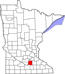 | |
| Townships | ||
| Unincorporated communities | ||
| Footnotes | ‡This populated place also has portions in an adjacent county or counties | |
Coordinates: 44°19′32″N 93°50′16″W / 44.32556°N 93.83778°W