Marysburg, Minnesota
| Marysburg, Minnesota | |
|---|---|
| Unincorporated community | |
 Marysburg, Minnesota  Marysburg, Minnesota Location of the community of Marysburg | |
| Coordinates: 44°14′25″N 93°49′01″W / 44.24028°N 93.81694°WCoordinates: 44°14′25″N 93°49′01″W / 44.24028°N 93.81694°W | |
| Country | United States |
| State | Minnesota |
| County | Blue Earth and Le Sueur |
| Township | Jamestown Township and Washington Township |
| Elevation | 1,050 ft (320 m) |
| Time zone | Central (CST) (UTC-6) |
| • Summer (DST) | CDT (UTC-5) |
| ZIP code | 56063 |
| Area code(s) | 507 |
| GNIS feature ID | 654821[1] |
Marysburg is an unincorporated community in Blue Earth and Le Sueur counties in the U.S. state of Minnesota.
The center of Marysburg is generally considered near the intersection of 243rd Street (County 16) and John Street. The junction of Le Sueur County Road 15 and Blue Earth County Road 26 is nearby.
Marysburg is located within Jamestown Township in Blue Earth County; and also located within Washington Township in Le Sueur County. From 1858 to 1903, the community had a post office. Marysburg is located within ZIP code 56063 based in Madison Lake.
Nearby places include Madison Lake, Elysian, Cleveland, Mankato, and Kasota.
Marysburg, a community at the south edge of Washington Township, in section 15, platted January 24, 1859,[2] was named by its first settler, John L. Meagher, an immigrant from Ireland, who was its postmaster during many years, and was also the probate judge for Le Sueur County. The community is also at the north edge of Jamestown Township. Marysburg was originally settled by immigrants from both Ireland and Germany.
References
- ↑ "Marysburg, Minnesota". Geographic Names Information System. United States Geological Survey.
- ↑ Upham, Warren (1920). Minnesota Geographic Names: Their Origin and Historic Significance. Minnesota Historical Society. p. 302.
Municipalities and communities of Blue Earth County, Minnesota, United States | ||
|---|---|---|
| Cities | 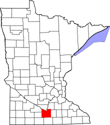 | |
| Townships | ||
| CDP | ||
| Unincorporated communities | ||
| Footnotes | ‡This populated place also has portions in an adjacent county or counties | |
Municipalities and communities of Le Sueur County, Minnesota, United States | ||
|---|---|---|
| Cities | 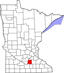 | |
| Townships | ||
| Unincorporated communities | ||
| Footnotes | ‡This populated place also has portions in an adjacent county or counties | |