United States Peace Index
The United States Peace Index (USPI) is a measurement of American States and cities by their peacefulness. Created by the Institute for Economics and Peace, the creators of the Global Peace Index, it is said to be the first in a series of National sub-divisions by their peacefulness. The USPI was created first due to plentiful data and a large amount of diversity between states for level of peace. The United States ranked 88/158 on the Global Peace index for 2012. The U.S. index was released on 6 April 2011, at 00:01 Eastern Time and the second edition released on 24 April 2012.
Indicators
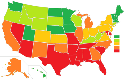
There are five peace indicators that make up the USPI. The scores for number of homicides per 100,000 people, number of violent crimes per 100,000 people, jailed population per 100,000 people, police officers per 100,000 people, and ease of access to small arms are weighted and combined to form a state's score. Maine scored as the most peaceful state both years.
Changes in peacefulness
The index also includes a map and list for changes in peacefulness from 1991-2009. States are scored in this section by percent, either positive or negative. As a nation, it says that the United States has improved in peacefulness since 1991.
Metro areas
The index also provides statistical analysis and crime, and the cost of crime, in the 61 most populous metropolitan areas. The Cambridge metro area in Massachusetts ranked as the most peaceful and the Detroit metro area as the least.
Lists
| 2012 Rank | 2011 Rank | State | 2012 Score | 2011 Score |
|---|---|---|---|---|
| 1 | 1 | | 1.31 | 1.34 |
| 2 | 2 | | 1.55 | 1.50 |
| 2 | 3 | | 1.55 | 1.54 |
| 4 | 4 | | 1.61 | 1.62 |
| 5 | 8 | | 1.72 | 1.83 |
| 6 | 5 | | 1.74 | 1.71 |
| 7 | 6 | | 1.78 | 1.75 |
| 7 | 12 | | 1.78 | 1.91 |
| 9 | 10 | | 1.79 | 1.87 |
| 10 | 11 | | 1.87 | 1.88 |
| 11 | 13 | | 1.93 | 2.08 |
| 12 | 7 | | 2.00 | 1.80 |
| 13 | 9 | | 2.07 | 1.85 |
| 14 | 15 | | 2.19 | 2.21 |
| 15 | 17 | | 2.20 | 2.28 |
| 16 | 16 | | 2.23 | 2.24 |
| 18 | 17 | | 2.27 | 2.28 |
| 17 | 23 | | 2.26 | 2.49 |
| 19 | 19 | | 2.30 | 2.30 |
| 20 | 14 | | 2.32 | 2.17 |
| 20 | 20 | | 2.32 | 2.39 |
| 22 | 22 | | 2.33 | 2.43 |
| 23 | 25 | | 2.35 | 2.52 |
| 24 | 21 | | 2.37 | 2.42 |
| 25 | 26 | | 2.48 | 2.61 |
| 26 | 24 | | 2.53 | 2.50 |
| 27 | 27 | | 2.57 | 2.63 |
| 28 | 28 | | 2.63 | 2.66 |
| 29 | 44 | | 2.69 | 3.30 |
| 30 | 31 | | 2.71 | 2.79 |
| 31 | 29 | | 2.72 | 2.69 |
| 32 | 31 | | 2.74 | 2.79 |
| 33 | 30 | | 2.75 | 2.70 |
| 34 | 38 | | 2.85 | 3.16 |
| 35 | 44 | | 2.89 | 3.30 |
| 36 | 34 | | 3.04 | 2.97 |
| 37 | 39 | | 3.11 | 3.18 |
| 38 | 36 | | 3.14 | 3.14 |
| 39 | 36 | | 3.15 | 3.14 |
| 40 | 47 | | 3.17 | 3.50 |
| 40 | 35 | | 3.17 | 2.98 |
| 42 | 46 | | 3.18 | 3.42 |
| 43 | 43 | | 3.20 | 3.27 |
| 43 | 47 | | 3.20 | 3.50 |
| 45 | 40 | | 3.21 | 3.21 |
| 46 | 33 | | 3.22 | 2.89 |
| 47 | 41 | | 3.36 | 3.24 |
| 48 | 49 | | 3.37 | 3.61 |
| 49 | 42 | | 3.41 | 3.26 |
| 50 | 50 | | 4.05 | 3.97 |
See also
- Murders in the United States by state
- Global Peace Index
- Global Terrorism Index
- United Kingdom Peace Index
External links
- Interactive US Peace Index Map
- Vision of Humanity - Global Peace Index Site
- Interactive world map of the Global Peace Index
- Institute for Economics and Peace
- Uppsala Conflict Data Program, an organized violence database
References
^ All information in table from "United States Peace Index". Vision of Humanity. Retrieved 2011-04-06 and updated 2012-10-17.
^ Map of state and city peacefulness across indicators
^ Institute for Economics and Peace
- Ian M. Harris, Mary Lee Morrison (2012) Peace Education ISBN 1476601771 pg 19
- David P. Barash, Charles P. Webel (2013) Peace and Conflict Studies ISBN 1452202958 pg 556
| Demographics | |
|---|---|
| Economy | |
| Environment | |
| Geography | |
| Government | |
| Health | |
| History | |
| Law | |
| Miscellaneous | |
| |