Upper Roxborough Historic District
|
Upper Roxborough Historic District | |
|
Shawmont Railroad Station (1834), Nixon Lane, Upper Roxborough Historic District, October 2010 | |
  | |
| Location | Roughly bounded by Shawmont Ave., Hagy's Mill Rd., and Schuylkill R., Philadelphia and Whitemarsh Township, Pennsylvania |
|---|---|
| Coordinates | 40°03′29″N 75°15′06″W / 40.05806°N 75.25167°WCoordinates: 40°03′29″N 75°15′06″W / 40.05806°N 75.25167°W |
| Area | 711 acres (288 ha) |
| Architect |
Frank Furness Robert Rodes McGoodwin, et al. |
| Architectural style | Colonial, Greek Revival, et al. |
| NRHP Reference # | 01000463, 04001226 (Boundary Increase) [1] |
| Added to NRHP | May 2, 2001, November 12, 2004 (Boundary Increase) |
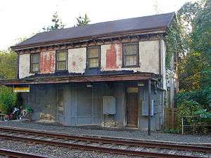
Upper Roxborough Historic District is a national historic district located in Philadelphia and Whitemarsh Township, Montgomery County, Pennsylvania. It encompasses 108 contributing buildings, 23 contributing sites, and 18 contributing structures in Upper Roxborough. The district includes a number of small scale farm and industrial workers' housing, estate houses, mill-owners' dwellings, and farm buildings. Notable buildings include the Shawmont Railroad Station (1834), Miquon Station (formerly Lafayette) designed by Frank Furness (1910), Riverside Paper Mills (c. 1720-1730), Hagy's Mill ruin, St. Mary's Church, and "Fairview" (c. 1856) and other buildings on the grounds of the Schuylkill Center for Environmental Education.[2] The Roxborough Pumping Station (c. 1860) was also part of the district, but it was demolished in 2011 after sitting abandoned for over fifty years.[3]
It was added to the National Register of Historic Places in 2001.[1]
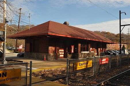 Miquon Station
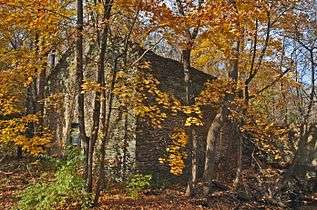 Hagy's Mill
References
| Wikimedia Commons has media related to Upper Roxborough Historic District. |
- 1 2 National Park Service (2010-07-09). "National Register Information System". National Register of Historic Places. National Park Service.
- ↑ "National Historic Landmarks & National Register of Historic Places in Pennsylvania" (Searchable database). CRGIS: Cultural Resources Geographic Information System. Includes: Emily T. Cooperman (n.d.). "National Register of Historic Places Inventory Nomination Form: Upper Roxborough Historic District" (PDF). Retrieved 2012-05-24. Note: While the first page of this document describes the Montgomery County part of the district as being in Springfield Township, the district's boundary indicated on the map at the end of the document shows it to be entirely in Whitemarsh Township, and merely bordering Springfield's "panhandle" which adjoins Philadelphia's border but does not extend all the way to the Schuylkill River.
- ↑ Szilagyi, Mike. "Shawmont Pumping Station Razed". Hidden City Philadelphia. Retrieved 6 December 2014.
| Topics |   | |
|---|---|---|
| Lists by county |
| |
| Lists by city | ||
| Other lists | ||
| ||