Washington Township, Buchanan County, Missouri
| Washington Township | |
|---|---|
| Township | |
 | |
| Coordinates: 39°45′44″N 094°49′48″W / 39.76222°N 94.83000°WCoordinates: 39°45′44″N 094°49′48″W / 39.76222°N 94.83000°W | |
| Country | United States |
| State | Missouri |
| County | Buchanan |
| Area | |
| • Total | 82.24 sq mi (213 km2) |
| • Land | 80.1 sq mi (207.46 km2) |
| • Water | 2.14 sq mi (5.55 km2) 2.61% |
| Elevation[1] | 879 ft (268 m) |
| Population (2000) | |
| • Total | 75,694 |
| • Density | 945/sq mi (364.9/km2) |
| FIPS code | 29-77236[2] |
| GNIS feature ID | 0766346 |
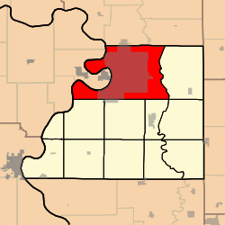
Washington Township is one of twelve townships in Buchanan County, Missouri, USA. As of the 2000 census, its population was 75,694.
Washington Township was established in 1842, and named after President George Washington.[3]
Geography
Washington Township covers an area of 82.24 square miles (213.0 km2) and contains one incorporated settlement, St. Joseph (the county seat). It contains nine cemeteries: Ashland, B'nai Sholem, Memorial Park, Mount Auburn, Mount Mora, Mount Olivet, Nelson, Ozenberger and Walnut Grove.
Browning Lake and Lake Contrary are within this township. The streams of Candy Creek, Roys Branch and Whitehead Creek run through this township.
Transportation
Washington Township contains three airports or landing strips: Butchs Strip, Heartland Hospital West Heliport and Rosecrans Memorial Airport.
References
- ↑ "US Board on Geographic Names". United States Geological Survey. 2007-10-25. Retrieved 2008-01-31.
- ↑ "American FactFinder". United States Census Bureau. Retrieved 2008-01-31.
- ↑ "Buchanan County Place Names, 1928–1945 (archived)". The State Historical Society of Missouri. Retrieved 4 September 2016.
External links
Municipalities and communities of Buchanan County, Missouri, United States | ||
|---|---|---|
| Cities | 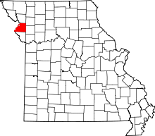 | |
| Villages | ||
| Townships | ||
| Unincorporated communities | ||
| Footnotes | ‡This populated place also has portions in an adjacent county or counties | |